mine shafts
over the canal opposite st pats rugby field there was three mine shafts but never new the name of the mine there was two on what was known as crap valley and one nearer to railway there is trees there now i think they have been capped the one near railway was not far from old turntable but it was even before my time they was on kimmik
Started: 1st Jul 2009 at 19:59
Ince Hall Colliery was there.
Replied: 1st Jul 2009 at 20:20
What years was Ince Hall Colliery operational.
Replied: 1st Jul 2009 at 20:22
Before my time, I'm sure! ![]()
Replied: 1st Jul 2009 at 20:22
I have a book Lancashire Mining Disasters 1835 - 1910 and the pit was called Arley Mine owned by the Ince Hall and Cannel Company.
There was a disaster there in 1853 89 men & boys were killed by an explosion caused by firedamp.
In Feb 1896 the shaft at Arley Mine collapsed So it must have been working over 50 years
Replied: 1st Jul 2009 at 21:06
Thanks for that Johnny Seven, very much appreciated. ![]()
Replied: 1st Jul 2009 at 21:09
It wasn't you know. It was called the 'Ince Hall Colliery'.
The 'Arley' is a Lancashire coal seam that could have been worked at that colliery. It wasn't 'owned' by the Ince Hall company, but they could have been allowed to mine it.
* No Copyright held - please feel free to repeat this information as you please.
Replied: 1st Jul 2009 at 21:36
Last edited by tonker: 1st Jul 2009 at 22:02:55
The Arley mine was a seam of coal worked at many collieries in the Wigan & surrounding areas.
Replied: 1st Jul 2009 at 21:40
Do I hear an Echo? ![]()
Replied: 1st Jul 2009 at 21:45
1907 map
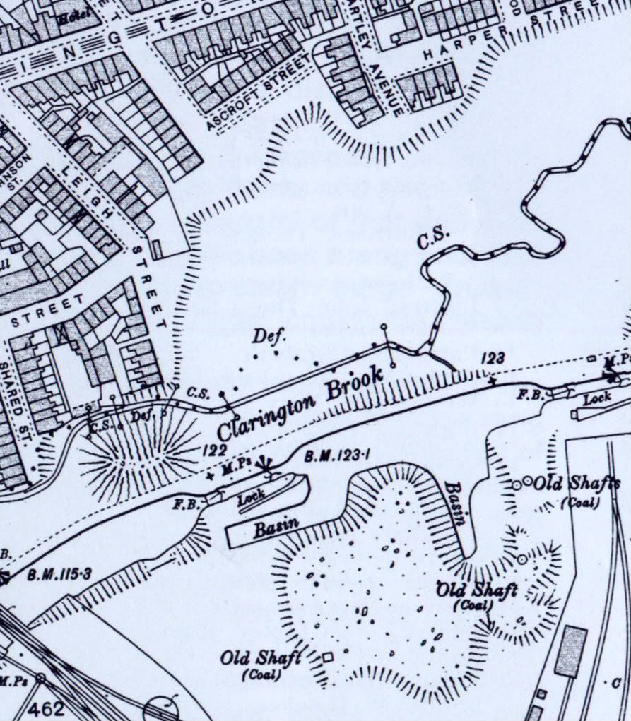
Mine list of the era.
63 Ince, Ince, Ince Hall Coal and Cannel Co.(Limited).
64 Ince Hall, Ince, Pearson and Knowles Coal and Iron Co. (Limited).
Replied: 1st Jul 2009 at 23:22
I remember reading the brass plaque on the left-hand front corner of what used to be the School of Mines. It says that within a 5-mile radius of the centre of Wigan there are 1000 pit shafts.
That data prompted me to realise why Wigan footpaths (pavements) are so uneven. Th'owd place is undermined to hell, and could sink out of sight any tick of the clock.
Replied: 2nd Jul 2009 at 07:32
according to tonker, there are no pits in Wigan! ![]()
Replied: 2nd Jul 2009 at 07:36
no pits in Wigan? Yes there is - the Town Hall - biggest cesspit in the country!
Replied: 2nd Jul 2009 at 08:17
danni, Ince isn't Wigan. They were all in Ince, Pemberton, Billinge, Haydock, Ashton, Abram etc. NOT in Wigan.
PS, maybe if I said there were, or there are, no 'mines' in Wigan, you might get the idea?
Replied: 2nd Jul 2009 at 10:50
Last edited by tonker: 2nd Jul 2009 at 10:56:35
Which part of Ince Pem,etc is Millgate,Central Park, Douglas Bank etc?
Tonker gets his facts from "Famous Five" & "Janet & John" books..![]()
Replied: 2nd Jul 2009 at 10:55
Does the Victoria Pit constitute Standish? Not bein awkward, just want to know!
Replied: 2nd Jul 2009 at 10:59
Art, as I've told you before, there is NO coal 'seams', or 'mines' as you like to call them, under Wigan. Any mining on the two faults would work away from Wigan, not towards.
Nicola, if it was IN Standish, then Yes, it does. (does Blackpool Tower constitute Blackpool?)
Replied: 2nd Jul 2009 at 11:01
Last edited by tonker: 2nd Jul 2009 at 11:06:16
Allright allright, calm down, just never knew where it was tis all[:o]
You weren't a school teacher in a former life were you Tonks?
Replied: 2nd Jul 2009 at 11:19
Confusion often arises in talking about pits, mines, etc.
Collieries, like Ince Hall, might be working more than one coal seam at a time, so they sunk shafts to different depths to reach the different seams. It was quite common that they would then refer to a particular shaft by the name of the seam it was used for. Hence, at Ince Hall, they might well have called one of their 'mines' the Arley Mine or Arley Pit.
So, both johnnyseven and tonker are no doubt correct.
Replied: 2nd Jul 2009 at 11:20
Am I supposed to believe you? I prefer to believe what I know, which incidentally co-incides with Wigan No2 Area NCB facts.
by the way the Arley seam was always known as the Arley mine, but to me, it was a seam.....Wrong again![]()
A few very old Wigan collieries:
Birkett Bank Wigan James Lancaster
Bottling Wood Wigan John Part
Clap Gate Wigan Henry Harrison
Douglas Bank Wigan John Ashton Chase
Four Lane Ends Shevington/Wigan William Barton... (Wigan Rural)
Swinley Wigan Exors of the Late Joseph Rylands
Holme House Wigan Henry Woods
Ince Hall Coal and Cannel Wks Ince and Wigan
Meadow's House Wigan Anthony Eccles
Mesnes Wigan Jonathan Blundell and Son
New Town Wigan Jonathan Lamb
Platt Lane Wigan Wright and Taylor
Shevington Wigan John Tayleur and Co...(wigan Rural)
Sovereign Mill Wigan Woods and Co.
Whelley Wigan Jonathan Lamb.....
Yes Nicola, The Vic was Standish
Replied: 2nd Jul 2009 at 11:36
Thanks Art ![]()
Replied: 2nd Jul 2009 at 11:40
Birkett Bank, Douglas Bank, Sovereign Mills, Swinley and Mesnes all in WIGAN centre tonks ![]()
Replied: 2nd Jul 2009 at 12:45
also.
4 Alliance, Wigan, Hilton and Clarke.
10 Barley Brook, Wigan, J. W. Darbyshire.
16 Birchen Heads, Wigan, Thomas Melling.
20 Blaguegate, Wigan, Winstanley and Co.
33 Dean House, Wigan, Lathom and Quirk.
37 Dove Lane, Wigan, Wigan Coal Co.
40 Elms, Wigan, Hoyle, Smethurst and Grime.
41 Engine, Wigan, John Scowcroft and Co. (Limited).
48 Gidlow, Wigan, Wigan Coal and Iron Co. (Limited).
49 Gidlow, Wigan, Thos. Gidlow
50 Gidlow and Swinley, Wigan, Rylands, Son and Co (Limited).
54 Grammar, Wigan, John Scowcroft and Co. (Limited)
55 Grange Hall, Wigan, William Walmesley.
99 Pilltoft, Wigan, Coop, Lea and Marsden.
109 Springfield (not working), Orrell, Hitchin and Co.
110 Springs, Wigan, J. Scowcroft and Co. (Limited).
111 Stonehouse, Wigan, J. Scowcroft and Co. (Limited).
124 Venture, Wigan, Jonathan Blundell and Sons.
Replied: 2nd Jul 2009 at 12:48
None of the aforementioned coal mines took coal from Wigan. Most (if any) weren't even IN Wigan. The ones that were would take 'coal' from the faults at each side of Wigan.
Replied: 2nd Jul 2009 at 13:28
I may be wrong, but when working on a site opposite Mabs Cross (before the flats went up) I heard tell of locals in the houses digging their own pits for cannel....or has time fogged my memory ![]() now surely Wigan Lane is Wigan?
now surely Wigan Lane is Wigan?
Now Tonks, don't lynch me, i remain to be enlightened in a nice way ![]()
Replied: 2nd Jul 2009 at 13:54
Mine's a pint. ![]()
Replied: 2nd Jul 2009 at 13:59
I'll have a can, if you're offering!
Nichola, there could well have been small amounts of cannel or lignite to be found near the surface on the Wigan side of the Haigh fault, but the coal measures are very deep in Wigan and certainly couldn't be accessed using mining methods of the time. To mine coal in Wigan, in any quantity, a shaft would have to have been sunk close to the fault-line either side of Wigan and the workings driven 'outwards', into the fault.
To get to the coal measures on the Wigan side of the faults, a shaft of about 2000 feet deep would have to be sunk and that would only reach the top seams.
All this crap about '1000 shafts within 5 miles of Wigan' is very misleading.
I'm not saying it's true, or false. What I'm saying is this :- any coal mine which is five miles from Wigan isn't a coal mine 'in Wigan'!
Coal mines in Pemberton were called Pemberton Collieries. In Ince they were Ince Collieries. The same goes for Standish, Leigh, Ashton etc..
The offices / commercial sections of the authorities and the coal companies could well have been in Wigan, but the coal mines weren't!
Replied: 2nd Jul 2009 at 15:50
Last edited by tonker: 2nd Jul 2009 at 16:15:06
Righty...
Replied: 2nd Jul 2009 at 16:26
Wrongy!!![]()
Replied: 2nd Jul 2009 at 17:16
Why are there signs all over Garswood saying "No To Opencast" ![]()
Replied: 2nd Jul 2009 at 17:21
Someone local has a mining company and they want to do some more opencasting in Garswood. However, the locals don't want it, so they're saying NO!
Replied: 2nd Jul 2009 at 17:33
I see ![]()
Replied: 2nd Jul 2009 at 17:36
Eeee by the crin! I only wanted to know how long it was operational.
Replied: 2nd Jul 2009 at 18:24
to gaffer where is 1907 map available our house is on it demolished now
Replied: 2nd Jul 2009 at 19:14
Last edited by watchalot: 2nd Jul 2009 at 19:56:51
watchalot
Where was your house?
Replied: 2nd Jul 2009 at 19:39
to gaffer/no eleven harper st opposite st pats there was bottling works then entry then no 9 my auntie lived there we lived next door all gone now
Replied: 2nd Jul 2009 at 19:43
to gaffer we lived second house on left coming from hartley ave
Replied: 2nd Jul 2009 at 19:45
to watchalot Harper street is shown on the 1909 map on the OLD MAPS site. It doesn't show Hartley Ave though, only Clarington Grove.
Did it only have houses on one side? over and out ....
Replied: 2nd Jul 2009 at 20:11
Last edited by tonker: 2nd Jul 2009 at 20:11:50
it had houses on one right side from clarrington grove to inglewood ave on right then houses on left to hartley ave no 2 to no 10 they are shown on gaffer 1907 map there was a school canteen there it is now part of st pats nellie underwood teacher at st pats lived at no 2
Replied: 2nd Jul 2009 at 20:21
Last edited by watchalot: 2nd Jul 2009 at 20:32:19
no 2 to no 10 houses still there /facing where i lived there is gardens there now and garages
Replied: 2nd Jul 2009 at 20:29
watchalot
Map as requested.
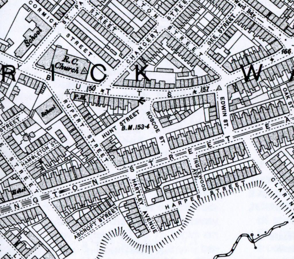
Replied: 2nd Jul 2009 at 20:57
tonker.
how would you classify the deep shafts north of Mesnes park within the new college grounds? these were capped in the mid 80's as part of a programmed I supervised.
I ask out of interest and not mischief
Replied: 2nd Jul 2009 at 20:58
you r a pal gaffer my house clearly showm 2nd on left fron hartley ave
Replied: 2nd Jul 2009 at 21:03
Last edited by watchalot: 2nd Jul 2009 at 21:06:29
When in a big hole stop digging
Replied: 2nd Jul 2009 at 21:35
orrellite, I would classify them as being sunk by the owners of the Pagefield Mill in an attempt to mine their own coal for mill use. I would say that they found the going tough, producing a certain amount of usable cannel, before giving up as a bad job when finding out that transporting the coal underground was more difficult than mining it elsewhere and transporting it to the mill on the surface.
Now then, I might be wrong in what I say, but if I'm wrong, the Coal Authority are wrong too, because it's their strata drawings that I studied, in mining engineering, for five years.
* also note, that when I say 'coal seams' I refer to the 'coal measures' which are thrown down by 1700 feet at the Pemberton fault, along with the graben that Wigan sits on, and only rising again to the Haigh fault. The river Douglas runs along both fault lines, each side of Wigan.
Replied: 2nd Jul 2009 at 21:38
Last edited by tonker: 2nd Jul 2009 at 21:41:26
eee bah gum tonks they should rename you terrier ![]()
Replied: 2nd Jul 2009 at 21:44
No, they should re-name you lot 'stubborn'.
Geologists and engineers know better than folk who've never had any dealings with coal mining at all. It's all very well saying, 'my grandad worked down pit' and 'so did my dad and his brother'.
That doesn't mean that YOU know all about it!
You're all just like that bloke from the Wigan Evening Post who insisted that Parkside Colliery was a Wigan pit, because it took coal from under Wigan borough!
Although, after I gave him an explanation as to where the workings actually were, he changed his argument to the fact that the colliery employed a few hundred men from Wigan. Sad.
Replied: 2nd Jul 2009 at 21:56
Tonker,
Suggest you read the actual report into the mining disaster at Ince Hall and Cannel Co Arley Mine Pit
Mining Report
Replied: 2nd Jul 2009 at 22:09
tonks with all respect just cos you studied it, dont mean you know it all ![]()
Replied: 2nd Jul 2009 at 22:34
Like I said earlier, danni, I only know what the Coal Board taught me. If I'm wrong, so are they.
Jonnyseven, to what extent do you suggest I read the report?
Replied: 2nd Jul 2009 at 22:46
nowt
Replied: 3rd Jul 2009 at 09:20
Last edited by nicola: 3rd Jul 2009 at 09:32:28
Well, folks, what I suggest is this: all of you stumble along, heading for the old School Of Mines building, bent on reading the brass plaque I mentioned. You might well trip over on the way, at which point you ask yourself, 'Why is it that Wigan pavements are so uneven?'
Regarding interpretation of the plaque wording, which surely to God must be factual, if you draw a circle of ten miles diameter with its centre in the centre of Wigan, there are 1000 pit shafts within that circle. From each and every one of those pit shafts there must be many balconies, along which our forebears crawled day-after-day which, bearing in mind that a shift meant 7 hours at the coal face, resulted in 11 and 12 hours underground. Underground and crouched down most of the time.
Replied: 3rd Jul 2009 at 09:57
Wonder why Wigan was referred to as:
"COALOPOLIS"?..![]()
Replied: 3rd Jul 2009 at 11:16
I suppose, this is a part of Yorkshire?![]()
The 1848 OS shows the Mesnes land as an open
area crossed diagonally by footpaths but that two
collieries and their tramroads were present as well
as marl pits and sand quarries. Mesnes Colliery No
1 was located just north of the Rectory (Hall)
grounds. No 2 described as a cannel pit, was situated
more or less near the present park main gate;
Mesnes Colliery. No 3 was located in the northern
area of the present park.
By the mid 19th Century, commerce in the form
of collieries and sand pits, had clearly established a
foothold in the Mesnes although the land was evidently
still being used for recreational purposes in
December 1863 when work was progressing with
the Rector's agreement on the construction of a
new walk on the north west side of the Mesnes,
"for the convenience and recreation of persons
visiting the Mesnes".
(Wigan Observer and Advertiser
18 December 1863).
Replied: 3rd Jul 2009 at 12:07
Jerry,
In support of your 1000 pit shafts, early mines were called "bell pits" whereby a shaft was sunk to the level of the coal seam, them mined outwards until the work became too dangerous, hence the name . Once this happened another shaft was sunk alongside down to the same depth whereby the coal could be mined.
Types of Mine
Replied: 3rd Jul 2009 at 15:59
Replied: 3rd Jul 2009 at 16:30
Bell pits were just a dot on the map in the mid 1800's.
Usually a few local lads dug near where there was an outcrop, not many feet under my back garden would be a good example![]()
Bell pit:
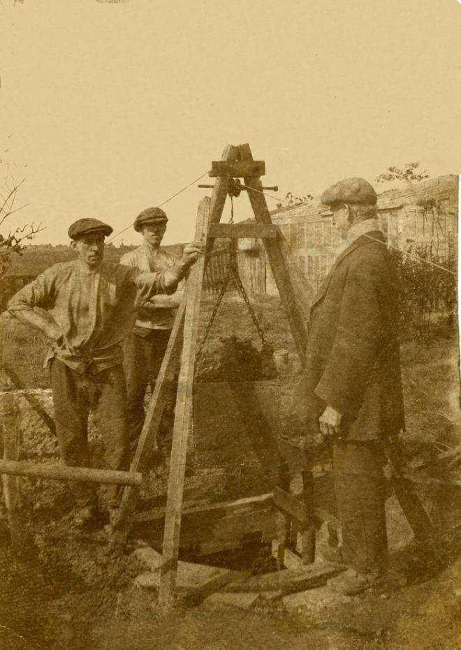
We're talking about mines such as this for example.
In March 1857, Messers CASE and MORRIS leased the seams of coal below the Pemberton Four-feet, known by the name of the
Wigan 4,feet, 5,feet and 6,feet and Cannel and King coal mines
Replied: 3rd Jul 2009 at 19:49
Last edited by ©art©: 3rd Jul 2009 at 19:52:56
Thank you, johny seven.
Apart from squinting at the 'School Of Mines plaque', my only source of related info is 'The Road To Wigan Pier', a chronicle of the latter coal mining days that should be compulsory reading in British schools.
Replied: 4th Jul 2009 at 10:56
I've taken this off another site I am known to frequent and was put together through a collective research/
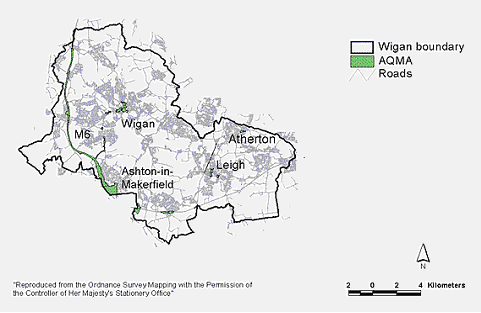
I've put together a bit of a summary for those who think Wigan does not have any mines under the town along with various pictures. What I have really struggled with are what are the boundaries of Wigan as Wigan Borough as it is now known includes the surrounding conurbations of places such as Ashton-in-Makerfield, Leigh, Golborne, Lowton etc
I thought that it might be a good idea to draw the information about mining under Wigan together into a bit more of a definitive guide. This is not all my work it is using information from earlier in the threads and is more of a work of the forum. Special thanks have to go to coalboard as a lot of information originates from that direction.
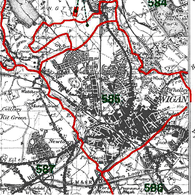
I found the claims that coal mining and coal measures cannot be found under Wigan rather confusing and startling as the recorded evidence is there to see. This then made me wonder what the area of Wigan should include. Wigan has had many changes of boundaries over the years whether it is through council boundaries, regional boundaries or others. I finally settled on the Parish of Wigan as a good place to start as this includes the town centre which stands central to the debate.
Map showing the boundaries of Wigan Borough today
From Wigan Council
[IMG]http://i112.photobucket.com/albums/n199/detritus21/wiganbore.gif[/IMG]
[IMG]http://i112.photobucket.com/albums/n199/detritus21/parish.gif[/IMG]
Wigan Parish Boundaries
from genuk
It is well recorded that there has been evidence of mining in the Wigan Borough for many centuries. The earliest recorded mining dates from the Roman era. Archaeological digs were undertaken in the 1980’s by Wigan Archaeological Society who found evidence of coal use in the town centre behind the Wiend. Also on a 1930’s map of Arley is marked supposed Roman Workings.
[IMG]http://i112.photobucket.com/albums/n199/detritus21/romanmap.gif[/IMG]
Map showing Arley and possible early workings. from Wigan Arch Society Website
Through the 17th 18th and 19th centuries Wigan helped fuel the industrial revolution with coal and mills being at the fore. Only after the depression following the 1st world war and the miners strikes of the 1920’s did coal mining start to decline in the Wigan area. The real nail in the coffin for mining was with the formation of the NCB who gradually decimated not only Wigan mining traditions but those of the country at large.
So what about the Parish of Wigan?
With Wigan town centre now being fairly built up it is quite hard to believe that mining ever really existed in this area. Claims have been made that no reserves exist but this is a bit of a fallacy.
Coals seams existing under the Parish of Wigan
Wigan 6 foot mine
Wigan 5 foot mine
Wigan 4 foot mine
Ince Furnace mine
Ince 7 foot mine
Ince 4 foot mine
Deep Yard Mine
Cannel Mine
King Mine
Arley Mine
Plodder
Within a four mile radius of Wigan town Centre there are approximately 1100 recorded mine shafts and with unrecorded mine shafts this number could be hundreds more.
[IMG]http://i112.photobucket.com/albums/n199/detritus21/wiganshafts.gif[/IMG]
1950’s NCB Area Shaft Team map. The dots represent mine shafts.
Pits of the Parish of Wigan
A number of recorded shafts and workings exist within the Parish boundaries along with many unrecorded shafts such as the one that recently opened up on Wallgate in November 2008.
[IMG]http://i112.photobucket.com/albums/n199/detritus21/wallgate.gif[/IMG]
Picture from Wigantoday
Recorded workings.
Peter Plats Mines
Perhaps some of the earliest recorded workings are those of Peter Plat. These are recorded in the Wigan Court Leet from the 17th century. Excavations in 1963 during the construction of Wigan Baths uncovered extensive workings thought to those of Peter Plat.
[IMG]http://i112.photobucket.com/albums/n199/detritus21/Archesinplace.jpg[/IMG]
[IMG]http://i112.photobucket.com/albums/n199/detritus21/Bricksforsealingoff.jpg[/IMG]
[IMG]http://i112.photobucket.com/albums/n199/detritus21/Oldworkingsandtimbering.jpg[/IMG]
[IMG]http://i112.photobucket.com/albums/n199/detritus21/Pillarsandvoids1.jpg[/IMG]
Alliance Colliery
Alliance colliery could be found in the centre of Wigan between Woodcock Street and Standishgate.
[IMG]http://i112.photobucket.com/albums/n199/detritus21/alliance.gif[/IMG]
Alliance Colliery Workings
Other known shafts within the town centre
Excavations behind Wigan children’s library by Wigan Archaeological Society unearthed a mine shaft. The shaft was of brick construction approximately 6 feet in diameter and filled with pit waste, bricks and stone.
[IMG]http://i112.photobucket.com/albums/n199/detritus21/shaft2.jpg[/IMG]
[IMG]http://i112.photobucket.com/albums/n199/detritus21/shaft3.jpg[/IMG]
[IMG]http://i112.photobucket.com/albums/n199/detritus21/map-1.jpg[/IMG]
Chapel Colliery Mine Shaft could be found on the west side of the mainline between the railway and Great George Street.
Two shafts could be found on Crompton Street under what is now the Bingo building.
Expanding to take in the remainder of the Parish of Wigan helps to demonstrate the true extent of workings and how much coal there really was and so some extent still is.
Just a stones throw from Britannia Bridge was Britannia Pit with one shaft and another unnamed Colliery with 2 shafts.
At frog lane municipal tip there are 3 known shafts
Meadows House Farm Colliery just off woodhouse lane opposite Ingram street 1 shaft
Meadow Pit and Douglas Bank 6 shafts
6 shafts off Barnsley Street for Barley Brook and Gidlow Lane Collieries
Rylands or Swinley Colliery 3 shafts off Walkden Avenue
Swinley Colliery 3 shafts between Swinley Road and Kenyon Road
Ince Hall Colliery behind the Cricket Ground 2 shafts
Mesnes Colliery 3 shafts
Then there are the collieries near Bottling Wood including 2 shafts in bottling wood, a drift mine, Platt Lane or Round house colliery.
Shaft at Water Hey
A Shaft near Wigan Little Theatre
Water Hey Colliery Scholes 3 shafts
Hardy Buts Pit at the end of Hardy Butts Lane 1 shaft.
I’m sure that some shafts will have been missed.
This map shows some of the known shafts on a modern map overlay
[IMG]http://i112.photobucket.com/albums/n199/detritus21/townmap.gif[/IMG]
If anyone wishes to have more added in particular any old photos post away.
Replied: 5th Jul 2009 at 22:16
Appears I've boobed I'm so used to photobucket links. I'll upload all the pics to the album tommorow and you can see the lot. The or just copy and paste into your browser page.
Replied: 5th Jul 2009 at 22:17
just change your links like this
[img=http etc and then close with ]
finally end with [/img] ![]() no spaces
no spaces
Replied: 5th Jul 2009 at 22:26
Last edited by danni: 5th Jul 2009 at 22:27:27
'What I have really struggled with are what are the boundaries of Wigan ' .... That says it all!
As for the 1000 shafts in a five mile radius of Wigan well, and I said this before, five miles from Wigan isn't Wigan!
It's pointless naming all the coal seams, because the same ones are under every town in Lancashire and beyond.
There's sixteen, classed as 'workable' in this area. From 1947, their agreed titles are as follows, top to bottom :-
London Delph - Crombouke - Ince 6feet - Pigeon House - Higher Florida - Lower Florida - Wigan 2feet - Wigan 4feet - Trencherbone - Peacock - Upper Plodder - Lower Plodder - Haigh Yard - Arley - Upper Mountain - Lower Mountain.
(Wigan 2feet and Wigan 4feet are separated by a 5 inch band of dirt and were mined together, sometimes called Wigan 6feet)
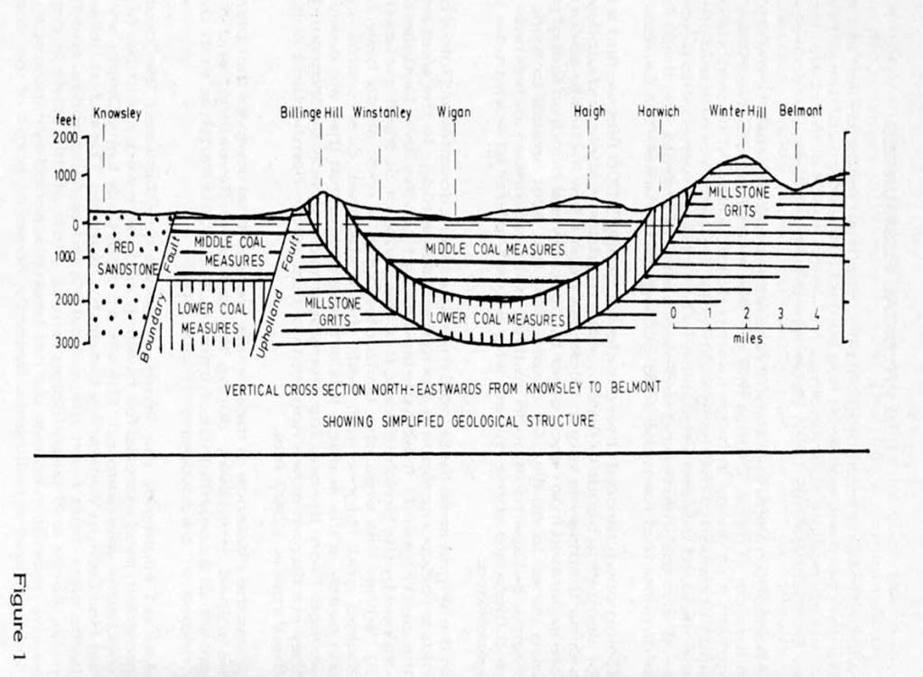
If you look at the drawing shown by gaffer although, as it says, it is very simplified, you will get a rough idea of how the coal measures are thrown down under Wigan.
The fault at Pemberton throws the strata down approx 1730 feet, returning at the Haigh fault. The river douglas takes the course of these two faults.
detrious21, don't waste your time and effort on displaying pits all over the Metropolitan Borough of Wigan. The Metropolitan Borough is not in question. There has been dozens and dozens of coal mines in the mining towns AROUND the 'mill-town' called Wigan.
Geologists have charted the strata from fault to fault, under Wigan, and shown the coal seams to start at around 2300 feet at Pemberton rising again at Haigh. Wigan is in between both faults (except the small part between the Douglas and Ince).
You see, anyone who doesn't even know where Wigan is, isn't going to understand why there wasn't much, if any, coal mining activity in the town.
Replied: 5th Jul 2009 at 23:02
Tonks......Change yer name to Cobblers..![]()
![]()
Replied: 5th Jul 2009 at 23:35
I love it when you respond, art. You're like a wasp round an owd jam jar! ![]()
PS: that's an 'owd' wasp round an owd jam jar!
Replied: 5th Jul 2009 at 23:40
Last edited by tonker: 5th Jul 2009 at 23:44:21
I don't know what boob you've made, detritus. Strikes me you've done a brilliant job.
Replied: 6th Jul 2009 at 10:41
detritus21, these are your first two photos
Replied: 6th Jul 2009 at 11:04
Owder 'n wiser,Gav..![]()
![]()
Replied: 6th Jul 2009 at 11:51
They stab it with their steely knives but they still can't kill the beast! ![]()
Replied: 6th Jul 2009 at 17:23
Tonker the pits I have displayed aren't all over the Wigan Borough. Peter Plats Mine was under the baths in Wigan. Last time I checked Library Street and Millgate are in the town of Wigan also the Parish of Wigan. The Wigan 6 ft mine outcrops just West of King Street and Wigan Four foot outcrops just to the east of Station Road. If you don't believe me check the Geological Maps for Wigan. The sheet you will need is 93NE. You will also find that Wigan 5 feet out crops along dicconson terrace. Where Gala Bingo is or is it Mecca on Crompton Street you would have found two shafts. Behind the Childrens library there was a pit. Chapel Colliery of Great Crompton Street in Wigan. I think you may have found a match on the knowledge of Wigan and the coal under Wigan town centre. I will post the pics but I am in a meeting in a second. I would love to talk about the mines under Wigan town centre or in the Parish of Wigan for hours. Is it a case of bury your head in the sand. It doesn't matter how many sites you say the same old clap trap on it doesn't change the fact that there was mining in the Parish of Wigan and henceforth the town of Wigan as the parish boundaries are pretty much the town boundaries unless you wish to show me the exact boundaries of the town of Wigan and I will again prove to you that coal is under Wigan. I await a wonderful conceited reply.
Replied: 7th Jul 2009 at 08:55
lol....Detritus, does your name hail from the mind of Terence Pratchett perchance?
Replied: 7th Jul 2009 at 09:03
I jsut like the thought of being named after a pile of rubbish/creepy crawly stuff. It came from an 80's christian heavy metal band of all things I just thought it was befitting at the time when I started forumming many moons ago
Replied: 7th Jul 2009 at 10:28
detritus21
some years ago I supervised driving a new drainage tunnel from adjacent to the new court building along the side of the old gasworks site and under the railway to what is now Range. the drive was approx 7m deep and on the leg parallel to darlington street we hit into old pillar and stall workings. I have not got a clue as to the name of the workings but they had definitely taken out the coal many years earlier. The workings were contaminated with lots of nasties from the gas manufacturing process such that our miners had to wear protective suits and air supplies.
Replied: 7th Jul 2009 at 11:06
HI i am joeb regarding mineshafts/mineworkings in the town centre area, i supervised the drilling grouting outside the baths for the new road. there are two shaft under the international pool the wigan 6/4 foot is worked and outcrops at the lights on chapel lane.
3 shafts were treated where the gala bingo is now, we angled some boreholes under the old central park from a drilling rig in the river douglas, workings were also found,we also drilled round the flats.
there are eleven shafts on the william foster playing fields area, we found grouted/capped nine, the missing two we believe were staple pits.over the last twenty years i have treated many mine shafts and mineworkings in and around the wigan area.
MINESHAFTS
PLATT LANE(scoles)3NO
WORSLEY MAINS 1NO
WALKDEN AVENUE2NO
MOSS PIT LANE 4NO
BICKERSHAW(the one with the the train lost down it)2NO
PLATT BRIDGE 3NO
LEIGH 2NO ATHERTON2N0 WE HAVE TRETED MANY MORE IN THE WIGAN AREA
Replied: 7th Jul 2009 at 12:47
With regards to Darlington Street close to the Gas Works there were 3 offical recorded shafts in the area. These being one shaft for Britania Pit on the North Side of the railway at the end of Orrell Street. There were also Kays Colliery Shafts which there were 2. These were located on either side of the railway just to the east of the range.
The likely seam to be worked would be Wigan 6 feet mine. At 7m the depth would be about right for the 6 feet mine looking at position of the crop and the position rough position of the range nad ht eold gasworks
Replied: 7th Jul 2009 at 13:14
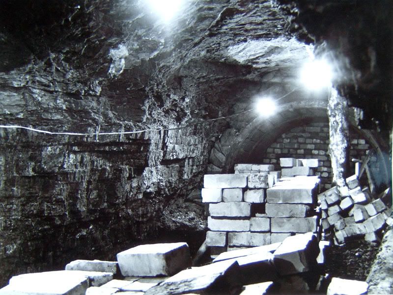
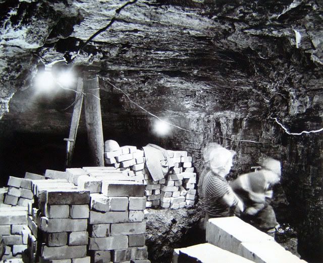
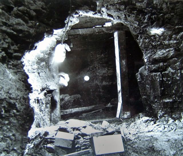
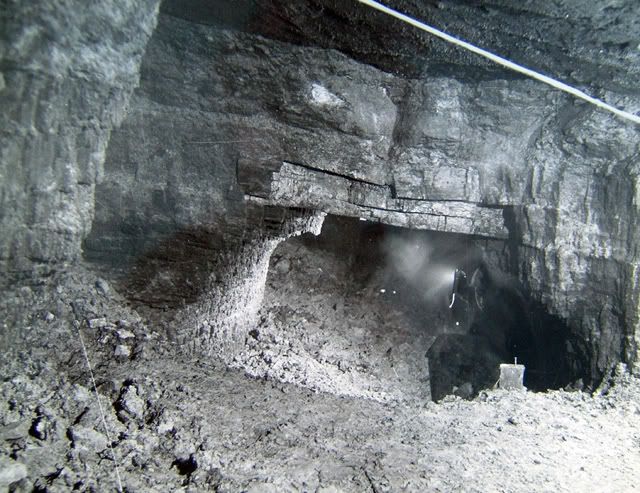
These should show pictures taken at the time of the building of the Baths. They show various parts of Peter Platts mine. These were taken i believe by Tony France author and also area geologist for the NCB at the time.
Replied: 7th Jul 2009 at 13:27