Photo-a-Day (Saturday, 19th June, 2021)
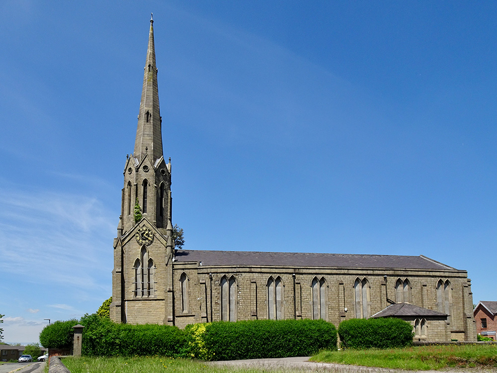
St Catharine’s Church

Photo: Dennis Seddon (Sony DSC-WX500)
Ive said it before that spending all that money trying to straighten it was a waste of time.
They should have knocked it down to the clock level and sold off all that stone to a builder who builds posh houses.
I'm no engineer by a long chalk, but the steeple doesn't contain enough stone surely to build a house. A wall maybe. Would it be dangerous to just leave it? It's stood nearly 200 years. The fault must be underground then? Perhaps that can be solved. There maybe an old mine under it.
I remember people relying on the church clock for the exact time. They didn't need a clock if living just across the road ...
Apparently built on a geological fault line, made worse by deep mining. It has been argued that the tower was too high in proportion to the nave, but I recall the twisted spire was restored a few years ago.
Whether future generations will pay for its upkeep is debatable but it was a definite enhancement of the Wigan skyline.
If I remember correctly the church was built over a geological downthrow which is known as the Great Saint Catherine Fault. Chris Southworth will know if he reads this.
True about the fault line Gary, and according to Wiki there's five in and around the Wigan area, for some reason St Catharine's (spelt with an e) is put at being in Ince, also which Standish church does the Giant's Hall Fault run under as there are three to choose from.
'Five substantial faults affect the Wigan Coalfield; they run nearly parallel to and equidistant from each other. The Great Haigh Fault begins near Bickershaw Colliery and passes northward through Hindley, Kirkless Hall, Haigh, and Arley to the west of Adlington Park. The Great Standish or St Catherine's Fault has a downthrow to the east and passes under St Catherine's Church at Ince. The Giant's Hall Fault passes by Abram, west of Ince Hall Colliery, west of Gidlow and under Giant's Hall Farm to Standish Church. The Great Shevington Fault passes by Hawkley Hall and east of Kirkless Hall. The Great Pemberton Fault is a downthrow and passes Pemberton, Orrell and to the west of Shevington.'
https://en.wikipedia.org/wiki/Lancashire_Coalfield
Are these fault lines still moving? There as been NO mining around these areas for at least 80-90 years so the ground should have settled by now
Thanks for the information Cyril. I had a vague recollection of a discussion with my Grandad about the Haigh fault lying toward Adlington. I had no idea there were five.
Peter - here in the North East, areas where mining ceased in the 19th century are causing problems for new build houses constructed in the last ten years. One Bellway cul de sac had to be demolished a couple of years ago with semis, less than 5 years old, forming a "v" shape as they sank into the ground.
Alexandra Colliery was working till the 1950s. Diary Pit, and Ince Moss were working till the 60s. They're all within a couple of miles of St Catherine's Church. I think damage to properties is more likely to be caused by subsidence rather than fault movement.
I think veronica means archet.
Here's a very interesting read about the geology or ground conditions to be found under Wigan and surrounding areas and how the geology became to be formed over the many years of prehistory. http://nora.nerc.ac.uk/id/eprint/510074/2/WN95003b.
The link isn't complete as I've missed 'pdf' off the end, so it won't connect. Here's the complete link: http://nora.nerc.ac.uk/id/eprint/510074/2/WN95003b.pdf
Do you mean architect Arthur? I think you're right.