Photo-a-Day (Monday, 12th May, 2025)
New Springs
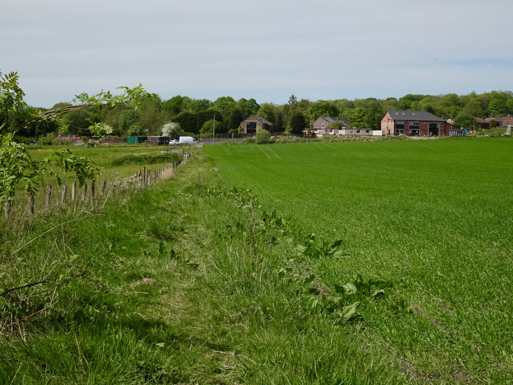
Photo: Dennis Seddon (Sony DSC-HX99)
Not being funny Dennis but I thought Springs Branch was at Spring View not New Springs which is at the top of Scholes on the way to Aspull?
Must confess I am always getting the two mixed up and might still be.
PS, could you be meaning the Whelley Loop Line??
Fascinating bit of history Dennis. We have a few disused railway lines here, aka Dr Beeching. Some hidden away like this one or made into walking paths.
My brother worked at Springs Branch in Spring View...it was railway sheds where engines were cleaned and maintained, but perhaps "Springs Branch Railway Liine" was connected to it.
I was wondering the same, maybe Aspulliters have known it as Springs Branch because that's were it went to.
I have to admit I live in Shevington so I dont know the area that well but I don't think I've ever got the two springs mixed up
I prefer the train any day to the motorway (when they are running on time) It was a bad mistake getting rid of the railways in my opinion. It could have been overhauled instead of adding more and more motorways. It’s far quicker and a nice relaxing journey. For an Island as we are I think it would have been better to invest more in the railway - the way that Europe does.
You were standing probably less than 200 yards from the spot where that Spitfire came down in 1942 when you took this shot Dennis .
Is this path marked on the map as a public right of way ? … as when I attempted to use it many years ago , the occupants of the house in the distance didn’t appear to be best pleased about me crossing their land , so I took the towpath as an alternative .
Lovely pic Dennis, very rural.Could be anywhere in England, you would never imagine the area used to be quite industrialised.
Dennis, I haven't seen that view for over 60 years.
Helen, a few years back I walked one of the Norfolk ex rail footpaths through from Great Witchingham and Lenwade - beautifully done with good pubs en route.
Colin, this line ran from Springs Branch up past Wigan Coal and iron at top place, across the canal via a bridge over what was known as “th’owd Arm” where it turned left and ran parallel with the canal to wards New Springs Bridge where it crossed the road and went on to the Sawmill and beyond.
Dennis is reet, that photo was taken on the former track bed of a railway line which went from the Alexandra and Lindsay Pits, across the canal and past the Haigh Saw Mills, and then across Wigan Road at New Springs, it then went across the fields to where Dennis was standing, and then on past the Albion Iron Works, the Kirkless Coke Works, and then it went over the canal again, going past the Top Place Steel Works, and across the level crossings on Belle Green Lane and Manchester Road in Higher Ince, the line then headed down and under Warrington Road at Lower Ince, it then went past the Springs Branch Rail Depot, before it joined the West Coast Main Line.
https://i.ibb.co/d04f7X7x/dp.jpg
Thanks Dennis for the information and clarification.
Some parts of Lower Ince are actually higher than some parts of Higher Ince. How daft is that?
And non if it is in Makerfield anymore.
Not heard of that walk Gary...but know Lenwade. Also know of Marriotts Way which runs from near the Cottessy (?) area of Norwich to beyond Reepham, once a railway line.
Map showing the line:
https://upload.wikimedia.org/wikipedia/commons/thumb/f/fd/Boar%27s_Head%2C_Haigh%2C_Hindley%2C_Pemberton%2C_Plank_Lane%2C_Strangeways_%26_Wigan_RJD_77.jpg/800px-Boar%27s_Head%2C_Haigh%2C_Hindley%2C_Pemberton%2C_Plank_Lane%2C_Strangeways_%26_Wigan_RJD_77.jpg
Thanks for that Strangeloop, that map couldn’t be clearer.
Helen - my elder son knows Marriotts Way. He lives fairly close to the route. A walk like that is beyond me now. Arthiritic knee!!
I wondered if there ever was an Old Springs?
I think the railways have promoted the confusion.
The location of their motive power depot is 'Springs Branch Junction'. However, in naming the shed, they have left out the word junction, 'Springs Branch' being the name which appears when referring to the shed. It does not take much for people to then start to call the location Springs Branch.