Photo-a-Day (Saturday, 1st February, 2025)
Ol' Man River, Dat Ol' Man River
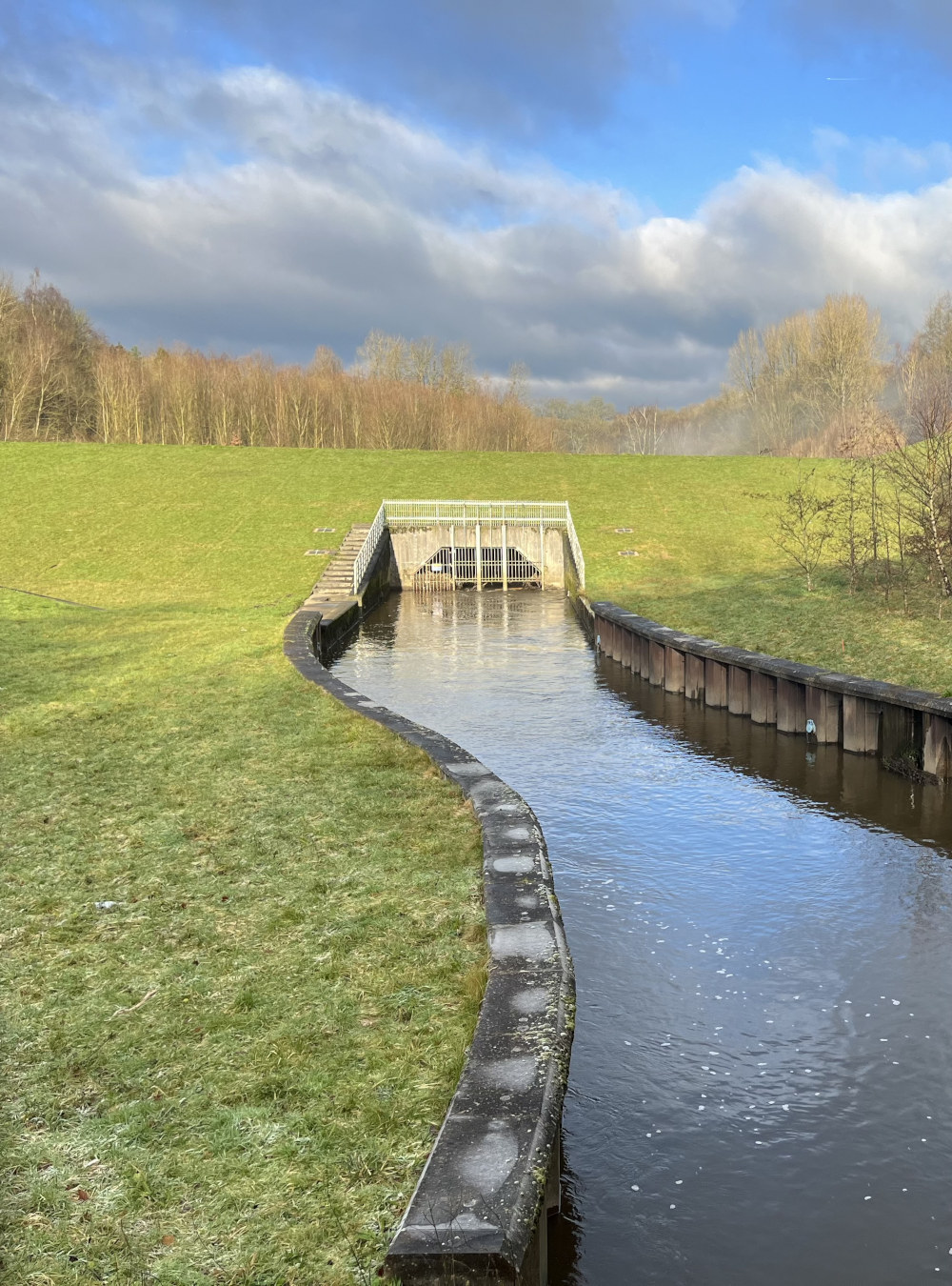
Despite the modern obstacle 'Dat Ol' Man River, he jes keeps rollin' he keeps on rollin' along.
Anyone for a swim up the Duggie?
Photo: Colin Traynor (iPhone)
It's technically known as a geocellular attenuation system or structure. I suspect it's gated for safety's sake.
A pleasant, peaceful scene Colin.
Depending on which day of the week you went into the Duggie years ago you would come out a different colour.
At least there’s no chance of building any houses on ground here….
The gate is actually a filter to stop rubbish travelling through to the other side.
You are probably correct Malc which makes me think of the bridge over the Douglas at the bottom of Scholes, it was much lower in the 1960's and has since been raised. After heavy rain, trees and debris trapped under the bridge blocked the flow and it overflowed flooding much of lower Millgate and Scholes and Derby Terrace..
I wonder what would happen if the same thing happened to this gate, would it back up and flow over the top of the Dam???? That would be worth a picture!
The lost Hamlet of Bottling Wood behind the Dam.
In March 2010, Oxford Archaeology North (OA North) was commissioned by Axis, acting on behalf of The Environment Agency, to carry out a programme of archaeological investigation in Bottling Wood on the banks of the River Douglas which was a former industrial hamlet dating from the 1800's perhaps even a little earlier.
The hamlet formed part of a designated Unhealthy Area that was outlined for clearance in the late 1920s by the Insanitary Houses and Conversions Committee of Wigan Borough Council, and was ultimately demolished in 1927-8.
John Noakes, it's there to stop Colin and his invited guests from swimming up stream.
"Ol' Man River" is a song from the 1927] musical Show Boat with music by Jerome Kern and lyrics by Oscar Hammerstein II, who wrote the song in 1925. this in turn was based on a 1926 novel by Edna Ferber.
The song contrasts the struggles and hardships of African Americans with the endless, uncaring flow of the Mississippi River. It is sung from the point of view of a black stevedore on a showboat.
Many will remember the 1951 film Show Boat with Howard Keel and Ava Gardner and of course the magnificent voice of William Warfield, not to be confused with Paul Robeson,
I seem to remember a lot of artefacts from the Battle of Wigan Lane were found under the soil around this area. Perhaps Cyril will know about that as I think it was his post I recall reading. I may be wrong…
I just read through some of the comments on yesterdays PAD and those made by .Ozy venting his spleen had me howling laughing with tears down my cheeks, my wife thought I was having a fit! Don't think I have laughed as much in years,
Hope he posts something as funny today but think he might still be in Curry's with his Chinese iPad.
After all the dreary dull days we’ve been having lately,this photo is a sight for sore eyes.
Prince Andrew (honorary member of Wigin golf club) has a Chinese friend who may be able to help with dodgy ipads.
Or the roof may have blown off the air raid shelter! Perhaps Big H could find him some scraps of iron coming back from the Big House in the plants.
Veronica, there is a photo on the Album by Ron that shows the buildings at the bottom of Coppull Lane: https://www.wiganworld.co.uk/album/photo.php?opt=5&id=30046&gallery=Coppull+Lane&page=1
I do remember the other page of information, but I can't recall from where I got it - I'm sure there was a map showing an archeological dig on the Bloody Mountains and before Fellside and other houses were built, and if I remember rightly they did find a lot of artefacts.
It could on the Wigan Archeological Society webpages, or maybe it was Manchester University and Wigan Tech, as they did do quite a few digs around Wigan at the time.
I'll pass on the swim Colin, as it won't be swimming with Dolphins it'll be swimming alongside unmentionables, courtesy of United Utilities sluice gates.
I remember the photo Cyril. I always thought Bloody Mountains referred to the the battle on Wigan Lane but it looks like it was a lot earlier according to one poster on the photo. We always played on the Camel’s Hump.
This looks like a pastoral scene from a story book. I grew up in this area in the 1960’s and the River Duggie was severely polluted and its river banks inaccessible. A huge improvement.
Veronica, I've been having a browse through photos on the Album and there was a post I put about the fields down Thornhill off Wigan Lane, it was around there that a civil war encampment was believed to have been, as apparently a lot of musket balls and other objects had been found there, a lot of houses have been built there now. I may well have mistaken this for the post about the Bloody Mountains, there was a dig there by Wigan Archeological Society, but nothing earlier than Victorian was found: https://www.wiganarchsoc.co.uk/content/Projects/Greatacre.htm
See the interesting comments about Brock Mill which is close to Thornhill, by John Barbour in this photo: https://www.wiganworld.co.uk/album/photo.php?id=27277
here are the digs by Manchester University: http://www.gmau.manchester.ac.uk/projects/wigan_archive.htm
Thanks Cyril I read all three. It was very interesting but disappointing when they didn’t find anything only old boots and a Victorian jar. I wonder what happened to the Canon ball the buckle and the silver sixpence of Elizabeth 1st period. I also remember reading about the Roman graves found on the Gas Work’s site. It looks like Wigan was a very important place in those times.
More than likely all probably ended up in a Manchester museum. It does seem that any interesting relics or those of some importance ends up in a Manchester or London museum, whereas we should have them on display in a museum here. A meteorite found in an Appley Bridge field ended up at the British Museum, London, and only then because the farmer sold it to them: https://www.wigantoday.net/news/people/wigan-authors-account-of-famous-meteorite-landing-is-turned-into-bbc-radio-play-4271979
This window on the history of Wigan by BETA is really quite interesting and informative: https://www.betanetcafe.co.uk/Window%20on%20Wigan%20Research%20book.pdf