Photo-a-Day (Thursday, 13th August, 2020)
Jodrell Bank
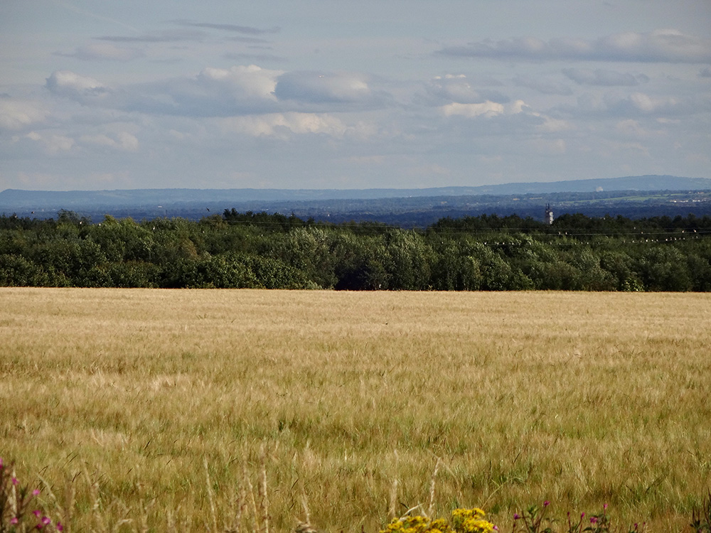
Photo: Dennis Seddon (Sony DSC-WX200)
That must be around 40 miles away, cant help wondering what are the hills behind Jodrell Bank, is it Wales or Derbyshire
Our house will be more over to the right on this one.
By gum Dennis, that's some shot. I recon it must be 30 miles or so to Jodrell Bank from Aspull as the crow flies. Looking over Hindley, Lymm and Knutsford, with the Derbyshire hills in the distance to the left of the picture, well done fella !
Mick, I don't think its Wales they would be more to the right of the pic,. Like you, I recon they are the Derbyshire Dales, Peak District National Park. But, there are a few places in Aspull where you can see the mountains of North Wales from.
Walt, I used to have a better view of the Radio Telescope from my back bedroom window, unfortunately the trees behind my house have grown taller and now obscure the view.
I remember watching the firework displays for the millennium from the same window, it was pretty spectacular.
Doesn't get much better - Jodrell Bank radio telescope is 63 years old and remains highly useful in its field.
I would never have guessed it could be seen from Aspull.
Distant views were a Rivington Pike thing - Irish Sea, mountains in North Wales etc.
Fantastic Dennis.
Mick, if you lived in Shavington near Crewe it would be, but you live in Shevington near Wigan which is behind Dennis and his camera.
Thanks for pointing that out Roy
Ive been to Shavington and remember a fatal car crash on the bends on Shevy lane, the lads in the car came from Shavington and had been in Henry Africas.
Are those birds on the wires Dennis ? They're quite a flock and I bet that swooping swallow could make Mam Tor in 15 minutes. My feeling however is that those distant uplands could be the north Staffordshire hills around Leek .
Yes, they are birds Poet.
The first town beyond Jodrell Bank from this angle would be Congleton in Cheshire.
Dave, on a map of the country i have drawn the proverbial straight line from Aspull through Jodrell Bank and onwards, it passed through the centre of Stoke which makes the hills on the right of the photo as you say, the lower Peak District behind Leek, running north to the left of the pic.
Brilliant photo !
I'd have a guess at the Cheshire end of the Peak district country park near Macclesfield. Information on here. http://www.gps-routes.co.uk/routes/home.nsf/RoutesLinksCycle/teggs-nose-country-park-walking-and-cycle-route
Surprisingly in good clear weather there's a good view of the Peak District hills from St Catharine's school on Scholefield Lane.
Good work Roy. Much obliged.
Your'e correct Dennis, Congleton is half a mile to the right of my 'straight' line. Brilliant photo by the way.
Wash the distance , wide and far ,
Void of barriers, walls or car,
Free to let my dreams explore ,
Let my mind just ease and soar.
Be a bird for just a mo,
Rise up high and look below ,
Look to distance yonder place ,
Leave for others and leave no trace .
Reminds me of the song....
On a clear day, on that clear day, You can see forever and ever, and ever , And ever more.
Lovely photo.
Gary you might be surprised where can see things from in Aspull. I well remember in 1984 we are at my Grandfathers funeral.at St David's in Haigh. After the burial we were walking through the churchyard and I suddenly realised that the mountain I could see in the distance must be Snowdon. It was a very very clear summer day with no heat haze, but it was very distinct.
Macclesfield and Buxton I'dsay.
I love these long distant pictures, and this is a great composition. Google Maps "measure distance" tool is great for plotting sight lines and distances, and seeing what lies in between and beyond, especially good in 3D mode and used with tilt and zoom. The tall structure to the lower right looks like it's part of the Hindley Green Industrial Estate?
Nippon Electric Glass, Bickershaw.
Dennis , do you live on Ivy Brow ? This is the view from my back bedroom window.
I remember when all the houses on Scholefield Lane were demolished. The view was spectacular looking from Belvoir St, made me realise was the street named after the beautiful view.
Dennis, Isn't there a name for the slope of the hill on the extreme-left?
Thomas(Tom), I took this photo with my back resting on the gate into Crawford’s Wood. I had just walked up Ivy Brow (or Bark Hill to give it it’s proper name) and had stopped to get my breath back.
I don’t know Philip, would it perhaps be Kinder Scout?
Brilliant photo.I think,coming from Aspull down into New Springs and Whelley.Must be the highest point of Wigan.
Edna, Broomhey Avenue, off Wigan Lane, is the highest point in Wigan.
James, are we talking Wigan or Wigan and district ? Land registry has Standish Water Tower and the adjacent cricket club 10m higher than Broomhey Ave and without searching any further I would suggest there are higher points than these. Highest point with a Wigan post code is actually Billinge Hill.
Roy, its said he is stuck over in Spain and so not been on here for some time, but since you've mentioned Billinge Hill and Wigan in the same sentence it'll be que El Tonko for sure.
Well Roy, it was Edna's suggestion that Whelley was the highest point in "Wigan" that made me think she meant Wigan, rather than the local government district of the same name.
As it happens, Roy, Billinge Hill is in St.Helens, is it not? and Haigh Hall is higher than the Standish water tower.
Belvoir, could well be right Veronica, never connected that until you wrote about it, as not only did the folks at the top of there get a beautiful view of the Peaks (until the tall Dutch houses were built that is) you also had a beautiful view of Billinge Higher Ends by looking down the street. If you are into nature and birdwatching here's something of interest by Dave Broome. http://www.manchesterbirding.com/uploads/9/7/5/1/97513866/billingehigherendssiteguide.pdf
Hi James, yes I know that Billinge Hill is in a place called 'spit' I never mention the place by name and close my eyes when passing through it on the train, I mentioned it, only because it has a Wigan postcode. Plus I know Haigh Hall is higher than Standish water tower, I named that, as it is slightly higher than Broomhey as a comparison, knowing that there are other much higher points in and around Wigan.
Part of Wigan is only a few feet above sea level. That's why the River Douglas floods near Asda.
At the other end of the scale, the highest point of Wigan is up Wigan Lane like you said.
As it happens, James, Billinge Hill is only half in St.Helens. The other half marks the highest point in Wigan council local authority area.
Thanks Cyril I'll look up the site. Whenever I'm in the vicinity , I still look at the view from Belvoir St and wonder why I never noticed it before the demolition of the old terraced housing. Because you can still see a long way from there over the rooftops further down the street. I used to roller skate down there as a child.