Photo-a-Day (Thursday, 24th October, 2013)
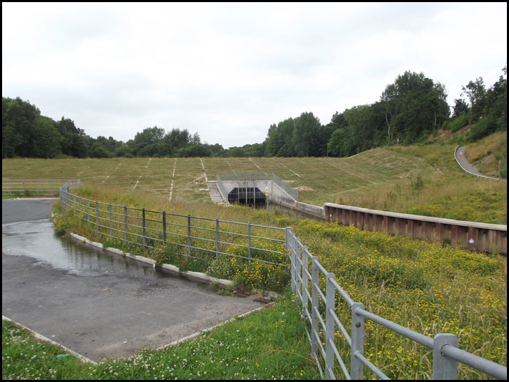
Tamed

Photo: dk (Fuji FinePix S2960)
It might look tamed but has it been tested yet? That must have been a big job.
where is this?
Theres some videos here of the Dam
http://youtu.be/e_aagzAODYk
http://youtu.be/XjQlNkbzUsQ
http://youtu.be/CNTGCfPWnx8
http://youtu.be/868uxCd0iBM
http://youtu.be/2ZqgEMt3nk0
http://youtu.be/K1ln-REZDdk
At the bottom of Coppull Lane Kath. Off Wigan Lane down by the side of the Swinley Club, the old Swinley Labour club.
KATH : It's in the Douglas Valley behind Main Street (Penson Street), down Coppull Lane. In the area we call "The Bloody Hills".
An area that was once teeming with the natural wildlife of fauna and flora, now totally destroyed and devoid of any life or scenery, this one time area of natural beauty has been poisoned and blighted forever with the unnecessary introduction of man made concrete and steel.
Mick, your has silly as Ernest with your useless information on each subject P-a-d offers. Nice photo dk.
The Bloody Mountains Marcus.
I have walked down here many times in the 60s, but don't recognise any of this. What's the path on the top right of the picture?
David (24th October 2013 at 16:55), the path on the top right of the picture is on the Bottling Wood side of the River Douglas. If you walk up the path it takes you into the plantations.
I think this is the downstream side of the dam. If so, the path to the right goes up to Whelley via Bottling Wood, and ends opposite where Whelley Hospital used to be.
Yes Roy...The Bloody Mountains.
David.. the path up on the right has been made since the building of the dam.. it leads up to the bottom of Bottling Wood steps or if you carry on.. to the little wooden bridge over the "Yellow Brook " into the plantations . As for calling it "A TAMED RIVER " take a look next time it rains hard !!!!
Mick...i dont need you to tell me how to Google.
This dam uses a "Hydrobrake" which is basically a conical shaped pipe, but constructed and sited in the middle of the "earth dam" we see in the photo. It controls the flow of water so as not to allow flooding in the Wigan/Newtown area. The whole system will hold about 370,000 cubic metres of water. The Hydabrake releases water at a rate which will prevent flooding.
The dam has been severely tested a couple of times in the last 12 months.
An interesting point is the series of brass studs embedded in the top of the dam. I'm told these are reference points whose exact positions have to be checked during and after a period of heavy rain when the dam has been under pressure.
Several such dams have been built in Europe, notably in Glasgow.
Who said "what a load of HYDRAULICS?"
Cyril, don't forget to mention that for at least 30 years to my knowledge, this area has been infamous as a venue for drug dealing, under age drinking, with the associated litter nuisance, and the " torching " of stolen vehicles. These issues appear to have mostly (although not entirely) disappeared now. Make your choice.
ahh. I know it. I've walked that path many a times going to mum's
at Bottling Wood.