Photo-a-Day (Thursday, 5th April, 2012)
Bridge
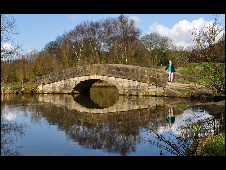
Photo: Phil Whitehead (Camera Nikon D90)
I remember that bridge. It's not until your not in Wigan any more that you realise what you miss. Thanks Phil
That archway is not big enough for a barge to go under.
I like the reflections Phil. Don`t like the colour of the pullover !!
This stretch of water is in front of where the Wigan Rowing Club boat house used to be.
Refer:-http://www.wiganworld.co.uk/album/photo.php?opt=5&id=3634&gallery=Haigh&offset=0
for a photo which shows this bridge relative to the boat house.
Further to my earlier comment: there`s a photo of Wigan Rowing Club boat house on :-
http://www.lqqk.co.uk/album/photo.php?opt=5&id=19834&gallery=Plantations+and+Plantation+Gates&offset=200
Some recent comments are below this photo including Maggie and Mick`s.
Nice photo.I like how the reflection has been caught on photo
Alan - the bridge may not be high enough now for a barge to pass under, but the basin it gives access to would have been built for loading coal from the numerous coal pits around there. If you look on Google earth, you'll see there are flashes in the fields across the canal in that area, indicating subsidence caused by the workings underground. As elsewhere, the bank will have been built up to maintain the levels in the canal - and the bridge will have sunk along with the ground it's sat upon.
Too far for me.
Good picture though.
This is the real one. We have sailed through this part of the canal, in fact, we covered almost all of the canal in our boating days, it was a wonderful experience sailing through the places where I used to play. So we must have been able to sail past the bridge. Lovely photo.
I posted a scan of a 1914 view of the bridge at: http://www.wiganworld.co.uk/album/showalbum.php?opt=5&offset=0&gallery=Wigan+Town+%26+Country+1914
From that you can perhaps see how much subsidence there has been over the past century.
Good shot, as Maggie says its too far for her. Thats why its good to get a good cross section of subjects for Wigan World. For the people unable to see for themselves. Be it animals,birds, buildings or scenes. Keep them coming.
nice shot of the ducks .
I seem to remember that the arch gave access from the canal to the rowing club house.
What a great photo. It is obvious that there is stil such a lot of Wigan that I have yet to explore.
this is a classic.In my Zeiss Ikonta 16 on a 120 days,1945, I would go to the West Riding to find bridge reflections like this. I can't understand not knowing about this bridge and I'm still not sure of it's precise location. Obviously a canal boat would not go under it so I assume it is connected with rowing boats. Ernie, the born again photographer, will like this. Not a sparrow in sight.
Thanks for the info Rev. Very interesting.
David Long, The basin that the bridge gives access to was built in 1900s so that the rowing boats could use the canal from their storage area,this bridge had nothing whatsoever to do with COAL or BARGES, why do people make comments when they just have not got a clue, My father was a rower on the canal,
Have Spoken to Mother, and she confirms that I am indeed, Maggie.
You need to get over the fact that many people share the same name.
Apologies to the less deluded.
Yeh thats just to the rowing clubs pond.
If you walk around it you can see that theres no way it could have gone to anywhere else.
Peter H, I am happy to be corrected on any matter of fact over which I may be mistaken, but I fail to see why you felt it necessary to couch your correction in such offensive terms. May I now refer you to page 3 of the following:
http://www.mikeclarke.myzen.co.uk/C&G/C&G7.pdf
Mike Clarke is the present-day authority on the history of the Leeds and Liverpool Canal, being the author of "the Leeds & Liverpool Canal - A History and Guide" (Carnegie Press, 1990). I think he has had sight of every scrap of evidence on the subject. If he allows Andy Screen to say that the basin was built for the loading of coal barges before the Rowing Club existed (and himself states that the bridge is the height it is because of subsidence), he's probably right.
I'm a mere amateur, but the basin appears on the 1849 OS map on the Old Maps site, and it's that which led me to conclude it was built for coal barges, rather than for rowing boats.
I wonder if there are two bridges. I have just uploaded a photo that I took in 1963'4 which shows the bridge very similar to the Rev's photo but then I just came across this one on WW taken in 1903.
http://www.wiganworld.co.uk/album/photo.php?opt=5&id=1193&gallery=Haigh+Hall&offset=0
Big difference??
Very similar bridge but much lower in the water??
My photo should appear soon on
Places
Haigh
Having read some of the comments on this photo today Simon and Garfunkels hit Bridge over Troubled Water springs to mind
BTW Phil nice shot
Link to my 1963'4 photo
http://www.wiganworld.co.uk/album/photo.php?opt=5&id=20350&gallery=Haigh&offset=0
Fred Mason,it`s the same bridge and but for the trees in Phil`s photo, Haigh Hall would be seen in the same place as that on the postcard in 1903.The canal is practically dry and that explains it.
Sanibelfred-look at the old postcard and you`ll know where this bridge is when you see Haigh Hall.
David comment at 10:54: look at the photo`s mentioned in my earlier comments.
It`s about time that the maggie`s sorted themselves out. I`m sure everyone agrees.
Fred Mason,Just looked at the 1963`4 photo--same bridge -basin is to the left.
I went to the registry office to see if I could have my name changed to Maggie by deed poll. They told me it would cost more than thirty five pence, so I told em to shove it. Does it really matter how many Maggie's are on here? I'm sure the "Normal" user's on here can make up their own minds who to acknowledge and who to ignore.
Regarding the canal basin, whilst serving the needs of local pits, it was used for the dispatch of products from Haigh Foundry. It was also used extensively receiving supplies of goods to Haigh Hall. All this is well documented, eg see 'Life and Times at Haigh Hall' by Donald Anderson. Rev Long is correct regarding the subsidance in the area - on the East side on the canal, the Cannel Mine was at a very shallow depth and was mined extensively. Google Maps also show the remains of numerous 17th Century bell pits (as small circles).These are also well documented (see the book 'Wigan Coal and Iron' by Donald Anderson and Tony France, p17). This seam was later accessed from drifts driven from the West side of the canal, close to the basin.
Thanks, Ernest,
So that means that the bridge has really sunk then. I wonder if any kind person can take a photo of the bridge from the iron bridge where I took my photo from please..! Then we can compare 1963 with now.
Many thanks.
i love this part of the canal bank as I walk my dogs here regularly.
Beautiful picture,Rev,there was an opencast coal mine to the left of the photo long ago,I remember it being rehabilitated when I was cross country running there.
I think the Reverend is correct. the basin was originally a loading point for the pits that lay on either side of Hall Lane/ Basin Lane.the pits can still be seen fenced off just to the side of the roadway
What do you have to say now Peter H?
Perhaps an apology to Rev Long!
Some very interesting poonts of view being expressed. I do believe you are missing a point though, surely if there had been so much subsidence over the last 100 years the bridge would have collapsed. What has changed though is the water level!! Much higher in the current photo.
Steve - you're right in a sense - the water here is deeper than it was originally, but that is because the bottom of the canal has sunk because of the subsidence, and the banks have been built up to retain the water - otherwise it would have flowed over the towpath, and would have been draining the 10-mile pound between Top Lock and the bottom of the Johnson's Hillock flight beyond Chorley. As the subsidence is quite localised, that would have led to the canal being too shallow for navigation in that area.
Such subsidence is well evidenced around Wigan itself - Dover Locks at Abram had to be replaced with the locks at Poolstock, and Crooke Lock simply became redundant as ground levels altered.
As for the bridge collapsing - unless a fault is involved (as happened with St Mary's church here in Ince), ground which is undercut by coal mining usually sinks at a uniform rate over a prolonged period (depending how deep the workings are). Poorly founded buildings will twist and may fail, but generally buildings simply go down safely with the ground they're stood on.
Precisely what I said re water level at 19:50 yesterday steve mercer.
That is the record, for number of coments. phill
A parr Adelaide: number of comments will be increased when Phil adds his comment !!
Where are you Phil--in the Bahamas!!?
In the 1960s the the sunken, and part sunken rowing skiffs could still be seen in the water.
Well i see i have quite a few comments on this one.
Ernest Pyke, i wish i was in the Bahamas but Hindley Green is the next best thing.