Wigan Album
Lymm St./Boundary St. area.
18 Comments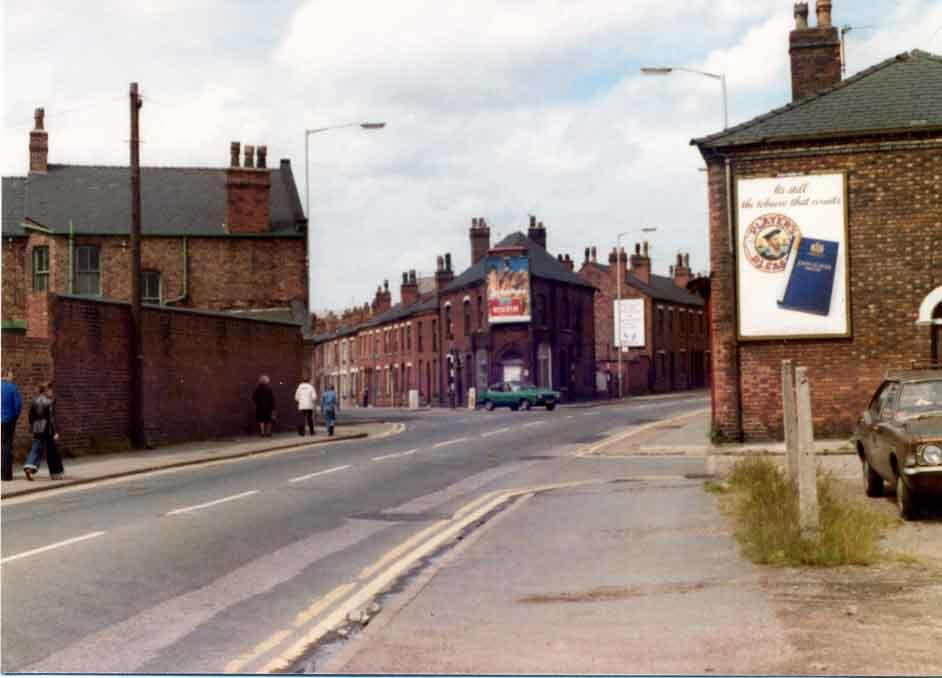
Photo: Allan Greenwood
Item #: 8791
I don't know when this picture was taken, but the houses on Warrington Lane, in between Lymm St. and Boundary St. had already been demolished. Whether or not Lymm St. had also been demolished I don't know
I'm perplexed - from which viewpoint was this taken?
Hi allan, where was the metro yard on here.
is that the hairdressers on the corner?
It looks like it was taken from where the front of where Heatons bakery is,across from Twists cafe.
It was taken on Warrington Lane looking towards Wigan. The wall on the left was the Corporation Streets Dept and the police mortuary.
the house you can se where the green ford capri is was ours number 33 soverign rd our back door was on warrington lane our family name was the joneses dont know if any one remembers us
My nan used to live 2 doors up from the end house on the right, a place where i spent many happy times in the 60s
The shop at the end was a dress shop called Lillian Smiths. Just behind where the picture is taken, was a grocers that we used to use as they had a 'penny tray' and a little further down was cloggers shop on the corner of Lymm st and Warrington lane.
The shop facing on the corners of Sovereign Road and Warrington Lane had a multitude of uses , I remember it being a second hand shop though.
Fantastic pics Allen, keep them coming
Seems like you have all got it taped. You don't need me to answer. The grocers shop was Bert Hills, Lillian Smith's shop can't been seen on this photo, it was up by the traffic lights.
I believe the shop on the corner of Sovereign Road and Warrington Lane, was the 'Tripe Shop' where Eric Blair i.e. George Orwell stayed when he visited the town.
The shop on the corner was a second hand shop for a while. Before that it was a chippy and the same people had the shop on Sovereign Road itself [half way down on the left]on the corner of a small street that led into a side gate of the gasworks. Not at the same time though but I can't remember which came first.
Hi Anthony
I used to work with a girl named Marjoria McGrathe she lived on Sovereign rd,dont know how old you are but i am talking about the 60s early 70s can you remember anyone with that name?
The Council yard is on the left where you see the wall and the properties beyond the car in the middle of the picture are now all demolished and the site is now a car park. There is the sculpture of trees on the Darlington Street
side of this car park near to the traffic lights. The shape these buildings formed was of a triangle - some on Darlington Street some on Warrington Lane and the rest along Sovereign Road with the Gas works on the left.
I think what might be causing the confusion is that the wall of the council depot has now been replaced with palasade steel fencing.
it looks like birkett bank to me turn right to st catherine's church
i jm yes i do remember a family by the name of magrath. i am 51yrs old but i cant remember marg.in my street ther was the yates/crooks/ sorbeys/greenacres/ other surrounding familys i remember where the websters ps they had chip shop/tarbucks/jacksons/nicolsons/ticklers/mcgloughlins/there was plenty with big familys in those days
thanks Anthony
marg and i are 10 years older than you so she may have left home when you were only a babe,her parents were proberbly still there and its them you know the name from.
Thanks anyway Jm {lady}
Hello everyone who knows us. I'm here on my 50th birthday with Martin Mcloughlin, Stey Mayor, our Kevin, my sister Julia, her kids, husband etc. Martin was brought up here and would love to pass his regards on to everyone, as would the rest of the Snee and Mayor Clan, Best Regards
shop on corner was our familys chippy then they moved halfway down the road on the left side as you look at the pic. used to be a shop across from that which was secound hand shop and across from the gas works was the hairdressers owed by maureen