Wigan Album
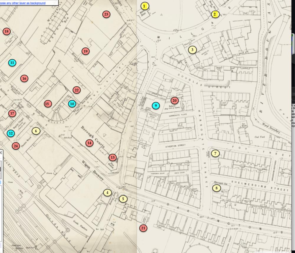
Wigan Map 1888
9 Comments
Photo: Keith
Item #: 35452
Public Houses (1 to 8) yellow circles
1 Mitre Hotel 2 Horse Shoe Inn 3 Wagon and Horses 4 Brewers’ Arms 5 Derby Arms 6 Shakespeare Inn 7 Adelphi 8 Harrogate Inn
Places of worship (9 to 12) turquoise circles
9. Trinity Chapel (Presbyterian) seats for 600 10. Baptist Chapel (Particular) seats for 400 11. Methodist Chapel (United Free) seats for 650 12. Baptist Chapel (General) seats for 430
Public buildings (13 to 24) red circles
13 Fire Station 14 Borough Courts 15 Public Hall 16 Royal Court Theatre 17 Savings Bank 18 School Board Office 19 Mining and Mechanical
School 20 School - Boys Girls and Infants 21 Slaughter House No.1
22 Free Library 23 Public Baths 24 Theatre Royal
Very interesting, Keith, and easy to follow with your system of coloured dots. Thankyou so much.
Thank you Irene. If you have an interest in maps then I can recommend going to the online free resource, https://maps.nls.uk/geo/explore/#zoom=5.0&lat=56.00000&lon=-4.00000&layers=6&b=ESRIWorld&o=100
Once you’ve got, as my father would say, “the hang of it” it’s a fantastic resource.
Thankyou Keith....I do like maps and particularly Wigan maps. I am not the sharpest knife in the box with technology but my son will find the above link for me if I can't.
Pink number 20 was where Wigan Agency was in the fifties. It was where a lot of mothers went to buy clothes with weekly payments. It had originally been a school as the map states. I loved going there there were separate rooms to try clothes on. They must have been the classrooms.
Of personal interest to me is that when you walk down past the Borough Courts towards Darlington Street, the first opening on the left is the continuation of Chapel Lane. The next opening on the left is not named. Walking down this opening however leads, on the right, to Preston’s Court (too small to read on this map). It was a very small street with extremely small, perhaps one up, one down houses. In the early 50’s I would visit my mother’s brother, his wife and their son who lived in one of these cramped residences, but by then it was known as Parr’s Court. I am all for renovation of older properties but in this case I think it would be hard to make a case against demolition, which took place quite a while ago.
I recognise some of the buildings that are still here today, the year 1888 famous for a mystery man known as Jack the Ripper who killed several prostitutes in the Whitechapel area of London. The Horseshoe pub was built in 1891 so it is not on the map.
Keith, first of all many thanks for posting this map, I could study these all day however I do have a few observations and comments.
Although the Map maybe 1888 I think the Cartography might be much earlier but stand to be corrected.
The reason I say this is that although The Central Railway Line from Manchester terminated at Darlington Street Station in 1884 construction of Station Road and Wigan Central Station which opened in 1892 must have been well underway in 1888 and neither Station Road nor the Railway Bridge over lower Millgate just before Scholes Bridge the river Douglas are detailed on the map.
I believe the original Horse Shoe Pub (2) was where it is shown on the map, I also think that it might have still been there for a few years when the Railway Bridge was built and then demolished when the new one on the corner of Millgate and Station Road opened circa 1891.
After the old pub was demolished Palatine Minerals had sites on each side of the Railway Bridge and underneath the arch beneath the stone bridge.
There was also a pub on the corner of Douglas Street and Millgate/ Chapel Lane which is not identified, this was The Douglas Tavern.
Off Harrogate Street, Harrogate Place is shown as a much longer lane, when I was young this was very much shorter and the land at the side of the School (20) had a large but disused playground backing onto the houses on Atherton Street and accessed from the top of Atherton Street.
I sent a photograph to Ron Hunt in July of HRH The Duke Of Gloucester walking up Harrogate Place 20th December 1934 to open The Junior Instruction Centre which is what the school had become.
If Ron reads this perhaps he will post it on The Album along with the comments I made at the time.
Thanks again Keith for taxing my memory, I always look forward to what you have to offer, especially the colorizations.
Keith, check out my comments on the Album, Duke of Gloucesters Visit.
Just seen your posts Colin, thank you for those kind comments. You are quite right re:-dates of maps. I too have found discrepancies so I just the put earliest date given and I also like to browse them especially when I have some familiarity with the area. Pubs are a great landmark to get your bearings as are churches of course. I noticed with Ron’s two churches the Elim one was much earlier then the Christ Church one but I wasn’t able to work out exactly by how many years, perhaps 50 or more. Palatine was a name I was very familiar with as a youngster, my father who ran a pub from 1950, used to order his soft drinks from there. I sometimes wondered where they came from. I’m sure a search of National Library of Scotland https://maps.nls.uk will reveal the Harrogate and Horse Shoe “evidence”, I shall have a look.