Wigan Album
Where is this?
17 Comments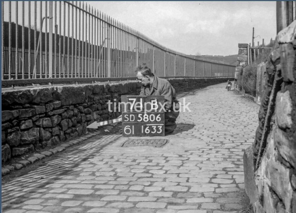
Photo: . Ozy .
Item #: 34924
Yeeees! Well done Ozy although you could say they are the ‘tip of the iceberg’ on the photo they were quite wide. I just wonder after the streets had gone what happened to the steps? The street above where they led to was quite high up. Thanks very much for posting. I’m going to ‘save’ this! ;o))and the map..!
I have to say how clean it looks down there after seeing the one on PaD so overgrown. Nowadays it looks as if you couldn’t walk along there anymore.
The next question is which photo is first this one or the one with the two ladies and the view of the Camel’s Hump? . Or is that a daft question? I would say this one is first
I would agree Veronica , and the clue is in the numbers and letters on the boards .
I don’t pretend to be able to interpret all the information on the boards , but SD5806 pinpoints the 1km square on the O/S map grid .
The numbers along the bottom line refer to some internal O/S filing reference as to the location of the film negative .
The A or B on the top line indicates that the photos were taken either adjacent to or opposite to each other and presumably the numbers on the top line go up as the team move along .
This particular shot 71B just happens to be No 561 of 931 photos taken in the Wigan north sector .
The other shot you mention 72A is numbered 565 of 931 .
72B , or No 566 of 932 , not shown here was taken on the same bridge but 20 feet away on the opposite bank .
And as the team gradually move along the river towards Coppull lane the numbers on the boards rise correspondingly , so it’s possible to a degree to track their route .
Also , some of the boards are marked with a date and If there is no date on the board , this indicates that the photo was taken either in 1949 or 1950 .
All a bit long winded and possibly boring for some but worth knowing nonetheless .
Check out the site yourself why don’t you .
You’d love it I’m sure .
Now I’m just off down to Walter Hayes to search for evidence of your blessèd steps , although I’m not feeling too optimistic if I’m being honest .
Veronica, if you look carefully you can see there are two gateways and, I think, these are to the houses which I spoke about regarding the other photograph.
I mentioned that the steps you asked about might have been next to these houses; possibly, they were initially built for getting to and from those few houses from the upper street area.
To be honest, my memory of the steps is not as clear as my memory of the other places around that stretch of the River Douglas. But! I certainly remember the houses, because my friends and I played in them when we were very young kids as the houses were empty and waiting to be demolished.
Veronica, possibly, that particular stretch of the path was kept clean by the people who lived in those few houses.
Regarding your question, I'm not sure what you mean, sorry. But, if you are talking about that cobbled path from Greenough Street to Maloney's Brew, this area (shown above) was and is before the footbridge area. Not far behind the photographer would have been the other footbridge which was quite close to the road bridge and those toilets.
Thanks for another great photograph, Ozy.
I’m not all that good at maths Ozy but I do get the drift. Don’t forget to take a photo of where the steps were. There must be some indication of where they were exactly. I have faith in you to find the exact spot… Good Luck Lord C.
Ps a before and after would be great. Even if it only myself interested!
Thanks for answering Ian. I had forgotten those little houses there that you mentioned playing in before demolition. All will be revealed.
Veronica , if you take the dog’s backside as your radial point , then plot a trajectory NNW of that point , you’ll see through the railings a light coloured area …
…See it ?
Well that light coloured area I’m convinced is the concrete parapet of bridge No 565 , or photograph 72A if you prefer .
The dog is just approaching the viaduct over the Duggie , and the bloke with the arrow is pointing it at the top end …. ( the pathetic non - functioning customer lift end ) … of Tesco’s car park .
Veronica and Ozy, I typed and posted my words (09:57) before Ozy's had appeared. Please accept my apologies for the information which is not aligned to the one above post. I could only see and read your post, Veronica, when I posted mine.
In answer to your post, Veronica (10:26), I would give a guess at the steps leading up to the first street on the left as you walked up Turner Street, which could have been Portland Street.
I think, there were three streets on the left: Portland St., Burlington St. and River Street.
By the way, wasn't there another street, which was off River Street? I vaguely recall a Weston Street, but I am not totally sure. I do partly recall that there were: Windsor Street, Oxford Street, Castle Street, Regent Street - probably, because of the names. I know that there was a Vaughan Street, but there were many small streets in this area and many on-the-pavement terraced houses which looked the same.
I can clearly remember that the fairground was held on the derelict land, some time around the mid-seventies. I think, in the sixties, it had been held on the cobbled Market Square.
Veronica, I forget to mention, I would say that the steps were removed when most of that area was completely changed. The three streets (Portland, Burlington and River St.) were, as to say, wiped off the map.
I am quite sure that Turner Street and Windsor Street are still there, but aren't the same as they were when all the terraced houses existed there.
For me, the whole area is no longer as pleasant and as interesting as it once was. Wigan had so much character and even those small streets, old terraced houses, small alleyways, stone steps, cobbled paths etc had something positive about them which the buildings and further development that now stand on those areas do not have.
Sorry, I have only just seen Ozy's posted map of the area (Item #: 34923) and looking closely at it, it looks as though these steps lead up to River Street.
Judging from the map, it seems that there was a path or steps at the bottom of River Street which then went to the right (as you walked down to the River Douglas) and came out where the houses were, which I mentioned.
But, I am not totally convinced about this, because on the above photograph the old Central Park stand can be seen and it runs far beyond these steps (on the photo), but on the map, the stand ends before the steps.
I’ve taken some photos of the probable site of your fabled steps Veronica . Problem is I don’t seem to be able to upload them onto this site .
Can't fathom what’s gone wrong , as I encountered the same problem yesterday ... I’ll figure a way round it in due course no doubt .
Good Lord! I see it , I see the light Lord C. North by North west! That’s where the two ladies were in situ.
l agree Ian but as for knowing if Turner St and Windsor St are still there I wouldn’t know. It’s like the “Land of lost content”. Gone forever. Perhaps the steps to Great Acre are still there looking on the bright side.
Ian, you're right about the Fairground being held on the land on Turner Street in the 1970s, and yes both Turner and Windsor Streets are still there along with St George's school which is a care home.
Central Park Way when being built knocked the stuffing out of the area around the riverside alleys and those streets, also Greenough Street was widened considerably.
Why the Fun Fair was held on Turner Street rather than the market square I wouldn't know, because the Pot Fairs were still held on Woodcock Street up to around the mid 1980s. The fair is held down Stadium Way these days.
I’m lost.
I need to make an amendment to a comment I made previously regarding the interpretation of the numbers on the Timepix boards .
The two numbers on the top row denote the 100 metre square within the 1km national grid reference square , whereas I’d assumed they were there merely to serve as a numbering system .