Wigan Album
Where is this?
46 Comments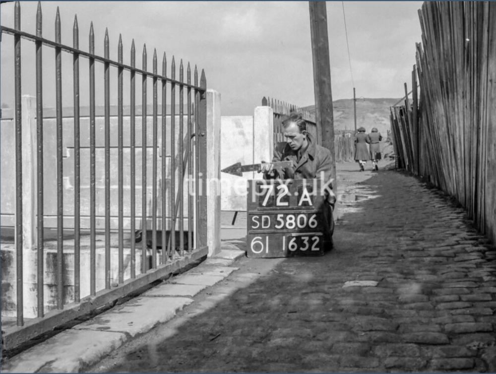
Photo: . Ozy .
Item #: 34918
Down the Duggy and away to the woods passing the famous Camel’s Hump. Still there but covered in houses. No more rolling down them thar hills as in days of yore. Only the cobbles left… it’s all overgrown these days.
I haven’t a clue but I’m sure someone on here will recognise it.
Veronica, I was, at first, not as sure as you are. But, you may possibly be correct as there are many details which say this could be that bridge and area.
One thing which deceived me was: I didn't realise that Camel's Hump was so high. I went up and down it many times and it was not always easy, especially in wet weather with the clay etc. But, it never seemed so high as it looks here in the photograph.
I clearly remember, there was a concrete footbridge at the bottom of Coppull Lane, which is no longer there as it was replaced by a more modern footbridge, and there were two more footbridges before you reached Greenough Street (main bridge for traffic etc).
Walking down the path from the Coppull Lane/Maloney's Brew footbridge there was the next concrete footbridge further down the River Douglas and this was certainly like the one shown. Also, there were railings identical to the ones in the posted photograph and there were cobbles which were very uneven. Furthermore, there was some kind of large wood/builder's yard at the side of St. George's School that had wooden fencing.
Additionally, just beyond the two ladies, it looks like there could be the steps which went up to Great Acre.
All these facts certainly lend themselves well to this being the place: the footbridge over the River Douglas which was between Coppull Lane and Greenough Street.
I feel I could have walked down there blindfolded. We used to come down a cobbled path to some stone steps with railings at the side - from a street off Greenough St. I can’t remember the name though. (It wasn’t Windsor St)
There is a photo of the bridge you mention Ian which was replaced. I am sat atop the bridge. I’ll see if I can find it and the item number. It was taken over the other side of Coppul Lane. It’s is more or less where the ‘monstrosity’ is to prevent flooding.
Item number 29988 Ian I think is the bridge you mention. That’s gone long since.
I too had forgotten as to how high the Bloody Mountains were, or they seem to be on the photo, it was all levelled off wasn't it when houses were planned to be built there, I say built, though as with the modern way of building they look so close together it seems like they were shoehorned into position.
Thanks! Veronica.
I don't recall that path you mentioned. But, weren't there stone steps and cobbled path up to the bowling green from close to St. George's School?
Also, there was a short cobbled street to Calderbank's scrap metal yard and there was a back alley (behind the shops) to the footbridge which took you to Central Park offices etc.
Additionally, there was a path, which was partly cobbled, from Great Acre and ran past the old farmhouse and past St. George's School. This path took you down to the street and then onto Greenough Street.
Sadly, I have yet to come across a photograph with me on. A few months ago, a photograph was posted and my grandfather was on it, which was a very happy occasion for me.
You would remember those steps if you saw a photo of them Ian. They were quite wide with an iron bar railings at one side. I do remember those steps to the bowling green I think the street was called Castle St. The steps I am talking about led on to those cobbles in the photo. They led from a street and on the corner was a house with a garden with large stone slab walls. The only garden with roses growing! The stone walls which surrounded St George’s school is still there I don’t know why or if those stone steps are there. I doubt they are because they led from a street which has gone.
Veronica, I probably would, as you said, recognize them when I see a photograph.
What I do recall is, there was a cobbled street on the left as you walked up a street to St. George's School. For some reason, the name Burlington Street is in my thoughts. At the bottom of this street was a brick wall and this was due to the fact that the street was on a much higher level to the River Douglas. Possibly, there were steps somewhere near.
Also, I remember, there were some houses next to the River Douglas and these could have stood below the wall. These few houses (3 or 4) had front gardens and could only be accessed from the cobbled path at the side of the River Douglas.
By the way, these houses were demolished some time around 1970.
Cyril, I had a wander around Great Acre about one year ago just to see what it was like. The houses (Camel's Hump) are on high ground, but I think that it was lowered and flattened a little to build on.
I remember, Great Acre area kids had their bonfire on Camel's Hump, which was impressive when the bommie was in full blaze.
With respect to all those who know far more than me. I was once more familiar to the Camels Hump/Bloody Mts. but the hills look more like Rivington. What argues against my thinking is that people are familiar with the foreground. I would suggest it might be a trick of the camera.
It’s got me thinking now…the bridge doesn’t look familiar. The bridges in my memory were iron painted green.
I remember the wood yard at the side. The cobbles and the Camel’s Hump look the same. They seemed really high up and open when we played on them. We took jam butties and bottles of water with us in the school holidays. Memory can play tricks ..I have seen this photo before it must be on here somewhere.
If you Google SD 5806 it gives you an archaeological reference that covers News Springs. However the number on the board may be nothing to do with this.
This Timepix photo number 1631 at the front of Central Park is on the Album by Ron,
https://www.wiganworld.co.uk/album/photo.php?opt=7&id=31512&gallery=Central+Park&page=2
and the path behind the shops which Ian mentions and also this bridge would be to the right and out of shot.
I was wondering when Calderbank's opened their yard there, according to the article in the link it was 1938:
https://metal-recycling.co.uk/since-1904/
In Calderbank's yard there was a tall mine ventilation shaft, and I remember them uncovering old shallow mine workings when they were building Riverway and Central Park Way, which they put concrete in, they most likely would have been the workings of the Alliance pit, which was mentioned in another photo
My minds at rest now Cyril and Philip. I thought ‘dementia’ was setting in. It is further back from where I was thinking. This would have been just after the smelly men’s urinals. We mainly came down the steps from a street off Greenough St. I would love to go down this side of the Douggy to see where the steps used to be. I once had a photograph of me on those steps. I don’t know where it got to. If only I still had it ….
The street leading to st.Georges school from Greenough St was Windsor St. Turner St. was on the left from Greenough St and Burlington St. was on the left of Turner St. before Turner St. joined Windsor St. I think this photo is taken in the vicinity of the playground of St. Georges School and just before steps led up to the the 1930s houses on West Mount , the unadopted road which started where Vine St. ended.
What was the street called that led directly to the steps I mean Derek?. I know people who lived in Turner St and Windsor St. There was a cottage with a garden on the corner on the edge of the steps leading down to the cobbled pathway as above in the photo. It’s driving me potty as Irene would say!
I can’t argue with any of the above comments. It’s only the height of the “hills “ that set me thinking.
Never mind Philip. Don’t forget this picture must be 70 odd years old. It really stretches the imagination. I don’t even know if you can still walk down that side of the Douglas these days. It was certainly well trod in my hey day. One of these days when I come into Wigan I am going to put my Miss Marple’s hat on and investigate for myself.
The street name that you’re struggling to recall Veebs … could it possibly have been River street ?
Also the bridge in the photo is still there although the concrete parapets have been replaced by railings .
It’s the bridge immediately adjacent to the viaduct that carries Central Park Way over the Duggie , the metal steps leading up to Tesco’s being 100 metres or so downstream on the northbound side of the viaduct .
River St doesn’t ring a bell Ozy but I am right it’s further back than the steps we used to get on the cobbled path which were a bit further down nearer to the high stone wall that enclosed St George’s school back in those days.
The name of the street is driving me crazy also, Veronica. Burlington St was the second of two streets on the left of Turner St as you went along it from Greenough. St . Both of these streets were dead ends but connected with one another across the bottom of each. The one driving us crazy was the last on the left of Turner St. before it joined Windsor St. and it did have steps down to the river. Just out of interest, on thestreet to the right at the bottom of Windsor St. there was a dairy and the owner's daughter was in my class at St.George's junior. Her name was Shirley but , for the life of me , I can't remember her surname. Any suggestions?
Yes Turner St and Windsor St then the street down to the steps with the cottage gardens at the end. Quite picturesque! Those streets must be on a map somewhere. I don’t remember the Dairy though Derek.
To give credit where it’s due , Ian nailed it in his first comment , ( as did Veronica in hers to be fair ) .
The path to the right near the two females that leads up to the bottom end of Great Acre , I admit I initially missed , although it is there if you look carefully .
Coincidentally, on Feb 8th , Colin uploaded a photo taken from almost the precise spot where the two ladies are , but looking in the opposite direction . Take a look.
So there we have it …
Mystery solved … game over . Thanks to all for participating .
Just a bit more. I can see now it is possible to walk down there where the two ladies are but it would involve walking under the road bridge which would not have been there at all at one time. There must be a ‘footprint’/mark’ of the past where those old stone steps used to be exactly. One fine day I will go and look…even though it does look a bit creepy and I’ll take the old iPad for good measure… Thanks for posting Ozy. I have really enjoyed getting to the bottom of this conundrum…I need to gerra life!
Thanks! Ozy.
Sorry for not typing more details, but I wanted my posts to be relatively short.
I would think that the steps up to Great Acre are still there and the footpaths on each side of the River Douglas are also still there. But, possibly, the allotments are no longer there. These allotments were on the left as you carried on along the path to Maloney's Brew: these would have been ahead of the two ladies. The path became a dirt path which wound around the bottom area of Camel's Hump.
By the way, I crossed the River Douglas many times and by the three footbridges on different occasions.
It was great to see that bridge again and I would like to take this opportunity to say thank you Ozy for posting the photograph.
I can see us all going down there with a magnifying glass in hand and a Sherlock Holmes cap on t’hed. ;o))
There’s a section on the Timepix site showing a bloke going around various parts of Manchester , wielding a cardboard arrow and taking “ then and now “ shots .
Given the amount of Timepix shots taken in our area , I was thinking It might make a nice little project for errrm…
...somebody like errr…
Let me think …
… Dennis let’s say … as he posts “then and now” shots now and then .
Or perhaps Mick could be tempted to come out of retirement .
I’d be willing to provide the pointy arrow ….I reckon I could manage that .
Then maybe DTease could be roped in , to follow the photographer around the district pointing at stuff ... He’s the lad for that job , and
If nowt else , It would give him the opportunity to get a bit of fresh air …Plus I’d be willing to lend him my gabardine mac .
Sounds like a plan to me …. Wot do you lot reckon ?
That would be fun! Especially wearing a gaberdine Mac…perhaps an old Army beret to hide any bald heads….;o)).
Its’ll be like Lord Carnarvon opening the tomb of Tutankhamen looking for the Lost Step's of the Left-Hand side of the Great River Douglas.
I’m off to Spec Savers next week I’ll be down there when I pick my specs up.
I am pretty sure the Shannon family lived along there, Angela and Gary used to go to St Marys.
Yeah ! Good idea that Veebs . If he wore one of his old tank tops , my long mac and his dad’s old army beret , he could pass himself off as Michael Crawford and flog a few autographs for beer tokens along the way.
A girl in my class at school was called Sylvia Shannon and she lived in the street with Stan’s Toy shop on the corner. Went there a few times to play. A lot further up though than Turner St.
So it wasn't the rugby supporters bridge, but a bridge that I hadn't placed, I did take our dogs for walks along there too, though it's over twenty five years since I was down there and I was thinking it would have been Calderbank's over the fence.
I do remember that path that leads to Great Acre and Riverside Avenue, because that path and other paths around there had bits of bread laced with anti-freeze purposely dropped here and there and was intended to poison dogs if they picked it up and ate it, and a few did which resulted in their agonising deaths, the poisoned bread was also found around the plantations and Haigh Hall. It took some time, but the culprit was eventually caught and dealt with by the RSPCA and the Courts. Thankfully the manufacturers began to put Bitrex or something similar in anti-freeze so it now is very bitter and not attractive to animals, before it was sweet and cats also licked spillages and they too had died from it along with wildlife who'd also picked it up.
Cyril, if I remember correctly, Calderbank's had a high brick wall and I think that there was barbed wire along the top.
Also, I am quite sure that the bridge near Greenough Street, which was between the alleyway and the parking area at the front of Central Park, had steps up to it.
So sad to hear about animals suffering painfully from bread laced with anti-freeze. There are some cruel people around. Not too long ago, I had a dog; I had him for fifteen years.
What an horrific story that is Cyril. It doesn’t bear thinking about what those poor dogs went through and their owners witnessing their agony. Very sad. It made me think of my grandchildren’s dog Mabel (Mabs) who is so affectionate, soft and friendly. They become part of your family -and loved just as much as them. Makes me shudder to think of folk like that. Rotten to the core.
Ian, I was thinking that Calderbank's may well have had a wall, as their yard would have been on the land where a factory had once been. I'd imagine there would be barbed wire on top of the wall and most likely a vicious looking dog in the scrap yard too.
It is very sad that folks pets had suffered, and sad that it was actually happening throughout the country too, where a lot of the persons accused of the poisonings were saying they were doing it to kill rats, but why would they be buying foods such as Sausages or Tuna to lace with anti-freeze just to kill rats? Ghouls comes to mind.
Ozy, a good photo that's brought back some great memories for folks and produced a lot of excellent comments. Though if you were to go out and about doing then and now photos, I'd think again about someone wearing a Gaberdine Mac, and especially wearing it around there, as the person may get mistaken for being a 'Flasher.'
Veronica , look at the recently posted Water Hayes feature on this site. It appears that the name of the street which has been evading us was, indeed , River St.
I think I may have told you about finding links of sausages and skinned rabbits behind the bowling club relatively recently Cyril .
No one’s followed it up to my knowledge .
Just thought I’d mention it again in case any dog owners missed it the first time around .
I have just seen the map Derek. River St must be the one. I am still wondering what would have happened to all those steps because they were wide and jutted out well on to the cobbled path at the side of the Duggy. It will be interesting and fascinating to see!
Veronica, looking again at the Water Hayes posting, I don't remember there being a Weston St., shown as a dead end and backing onto St. George's playground, and off River St. But there it is!!
Ozy, they could well be targeting Foxes, though I'm sure dog walkers would also use that footpath, I know I did when we lived down there and took the dog for a walk, we'd go along that path as a change from the bottom path.
I can’t remember Westminster St either Derek. All I know was going through Turner St and bearing left. I had forgotten Windsor St was further up there…. Castle St was another I remembered for the steps leading to the bowling ground.
Veronica, I don't remember steps leading up to the bowling green. I remember a cobbled path - was that an alternative way to the bowling green?
Wasn’t there a low wall going up the path on the right hand side? I may be wrong then about steps Derek…
Veronica, I seem to remember a cobbled path with a low wall topped with railings, but , it is a very long time ago since I was around there and I could very well be wrong.