Wigan Album
Aspull
10 Comments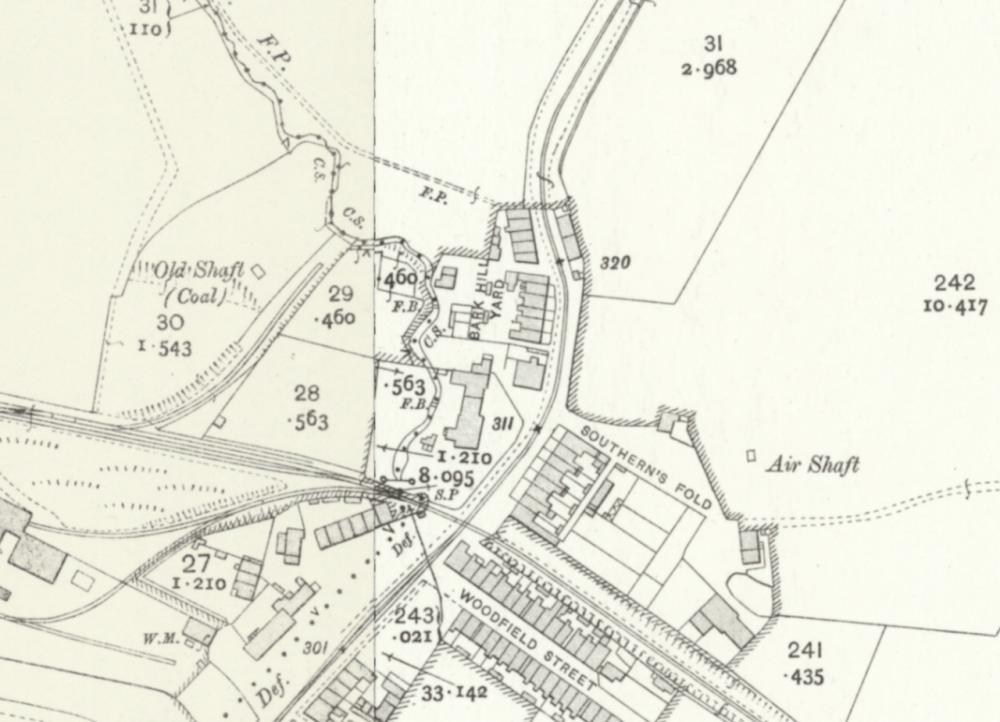
Photo: Rev David Long
Item #: 34851
Many thanks Rev Long my curiosity has been satisfied. A very interesting map of the area, I am sure others will agree.
Wish I new what some of the abbreviations stand for such as Def, F.P, F.B and C.B not to mention the many numbers? F.P might stand for footpath but that's just a guess.
There's a key to the abbreviations here:
https://maps.nls.uk/os/abbrev/a.html
They're not always straightforward - with some initials standing for different things - FB, for instance, can mean Foot Bridge or Filter Bed..., so you have to pick which is the most likely.
Def is not very well defined (ha! ha!), as it means 'Defaced' according to the key - but what it actually means is 'disappeared' - so on this bit of map, where Def is written to the left of the road, it means that the boundary which you can see running down the Centre of the Stream (CS) as far as the railway line (where a Signal Post is marked by SP) has disappeared from view - probably by being culverted - leaving no visible trace on the ground.
Rev, the boundary does not disappear, it's still there as a dotted line. You mean the brook disappears.
"Def", on an HMLR map, would represent 'defined' ie: the dotted line 'defines' the boundary on the map in the absence of any physical feature (brook / hedge / wall etc.).
Although, in Aspull, Def could very well mean "Definately the'er but tha' caun't see it"?
As I said, the brook is the visible boundary until it reaches the railway line, at which point it disappears from view - it does not necessarily disappear. From that point it is represented on the map as 'Def' - Defaced, according to the abbreviations key referenced. As I said, it's not a very well defined abbreviation - but it is the OS definition - and Land Registry maps are copied from OS maps - so I would expect them to use the OS abbreviations.
As for the fate of the brook - it is next seen on the surface in Bottling Wood, where it is known as the Yellow Brook. Looking at what's actually shown passing through on the map, however, I doubt if it is culverted between the two points - it is shown as crossing the canal and passing through reservoirs and tips - during which process I would suppose its waters would get dissipated (some going into the canal) rather than channelled. A similar thing happened to the Clarington Brook - the Wigan/ Ince boundary - when the canal was built. Around Britannia Bridge the 'Def' line showing the boundary veers off to the south and wriggles around along the line the brook originally took until it reaches the flashes. The waters of the brook, meanwhile, have been culverted off to the north, into the Douglas. So the the former visible boundary - the brook - has actually disappeared altogether.
Thanks both, very informative and appreciated.
" I would suppose its waters would get dissipated (some going into the canal) rather than channelled."
What a rather silly supposition.
The brook is actually culverted underneath the canal and reappears at the end of the car park to the side of the Crown Hotel.
In the light of your information, Mr Noakes, it is perhaps a mistaken assumption in this case, but it is far from silly. Most canals supplement their water supply from streams and ditches which cross their line. It can be a nuisance sometimes, as the incoming water often brings silt, which builds up and can obstruct the navigable channel. Excess water from canals is then usually discharged via spillways into convenient waterways to prevent flooding. In my years of travelling on canals I have seen this system operate hundreds of times - the water in canals has to come from somewhere - and the more such incidental sources can be tapped, the less infrastructure, such as reservoirs and feeder channels, has to be built.
When you try your best Rev Long to inform, I wish certain people would appreciate efforts and make any corrections in a polite manner.
The stream begins life as the overflow from the Swan Lodge in the Plantations. From there it goes underground and reappears on the other side of Higher Lane near Mowpin Lodge, From there it runs down hill, past Morris Fold until it goes underground where you see on this map and reappeared where John Noakes says at the end of the Crown Car Park. It then runs above ground behind the former St John’s School until it goes under the Whelley Loop Line near Canon Sharples School and then joins what was the Yellow Brook and runs into the River Douglas.
Thanks DTease, that was a very comprehensive description of the area.