Wigan Album
Newtown
14 Comments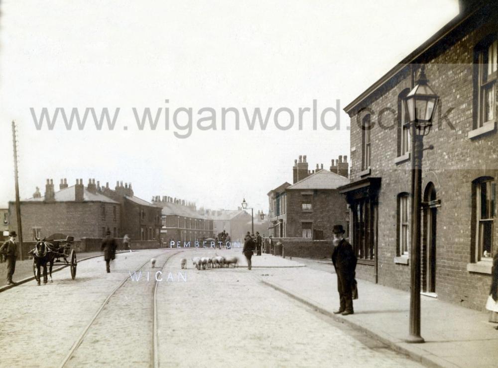
Photo: Ron Hunt
Item #: 34518
NOTICE THE GUY HERDING A FLOCK OF SHEEP<G>
I THINK IT MUST HAVE BEEN TAKEN USING A GLASS PLATES CAMERA
That's a great image, the man stood on the kerb at the right looks to have a bushy goatee beard, unless it's a blur on the photo, and those houses behind look to be solidly built so I can't see why they got to be demolished as I can't seem to remember them only with Frith Street and industries being there from the river bridge to the rail bridge, and yet the houses across the road was still there until the mid 1970s at least.
The man must have been given the freedom of Wigan town and that gives him the right to walk his sheep over the river Douglas bridge
Looking at the image again. I think they are pigs.
Yes Ron looking under a magnifier they are Pigs, either going to or coming from the market, or maybe bought from or going to another farmer.
Would Trickett's cattle market have been off Prescott Street in the early 1900s, or would the area which would become to be the cattle market still have been a goods yard then?
Is this anywhere near the Saddle?
The men look very smart and quite well off. Only one flat cap to be seen, near the cantilevered gas lamp.
Philip Cunliffe, this picture would have been taken from near the railway bridge looking towards The Saddle.
i remember there was an area called union bridge further up the road than this just before the library but did not know what it meant as i cant recall a bridge after the douglas
Union Bridge carried the mineral line from Norley pits over Ormskirk Road, there's a row of shops and a fuel garage across the road where the bridge abutments once were. Photo on the Album showing it here: https://www.wiganworld.co.uk/album/photo.php?opt=4&id=19238&gallery=ormskirk+road&page=1
There's a much better photo of Union Bridge here R.T. https://www.wiganworld.co.uk/album/photo.php?opt=5&id=1569&gallery=Newtown&page=1
The residents of the houses on the right may well have upped sticks and left because the area kept flooding, looking at the flooded area on photos the flood water in the downstairs rooms would have been around two to three feet deep at times, and have caused a lot of damage to electrics, wall plaster and wood fittings. So maybe the properties became uninhabitable and then demolished. The houses across the road was still there in the 1970s, this photo from late 1960s: https://www.wiganworld.co.uk/album/photo.php?opt=5&id=30130&gallery=Newtown&page=1
So maybe they was not affected the same when the floods came?
Photo of a typical flood in that area: https://www.wiganworld.co.uk/album/photo.php?opt=5&id=21296&gallery=Wallgate&page=4
Maybe the wall at the side of the river was built tall, as seen in the photo, in an effort to prevent flooding.
In reply to Cyril. I can remember some old houses near to Union Bridge. Probably 2 .This was probably 1990s. They were demolished before I took a photo.
Philip, I've had a look on Google maps and street view, and those houses may have been where Manor Street and Mitchel Street now have a wide junction with Ormskirk Road. It doesn't look as I remember it, and I'm sure I am remembering that neither Manor Street or Mitchel Street had a junction like they have now onto Ormskirk Road, there may have been an alley or suchlike leading to either of the streets, but nothing like it is now.
R.T. the petrol garage is now a car wash and the row of shops do not look as new as they once did, it was at one time Plessey who had a works there, and up the side street there was a path that led to Worsley Hall, which we would go along to the prefabs on Laithwaite field where we once lived, I've been told that along there are now workshops and a funeral directors repose.
The house I lived in until I was 17 is on this photo. It was built in 1873. On the left the three houses that jut out its the end one before the turning into Trentham Street. It was a pub at this time but later turned into a house.