Wigan Album
Springs Branch
15 Comments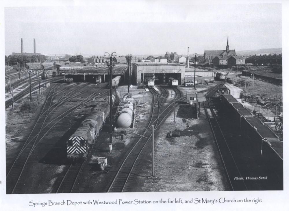
Photo: RON HUNT
Item #: 28539
Westwood Power Station, St. Mary's Church and a view of the Springs Branch Sheds.
This is great, Tom. I can see St Mary's Church and Westwood Power station that was demolished in 1988.
What year would this be.
Thanks Ron for uploading.
Remember on some Sundays in the 1960s a cousin, some mates and myself would go into that yard trainspotting, no one ever said anything or stopped us even though engines were shunted around and being maintained, we never thought about any dangers.
Are the two rows of houses you can make out under the Westwood Power Station chimneys, what were known as the KAYS HOUSES?
No, Ron - it's clearer on the original Tom sent me when I made this Calendar up for St Mary's, but what you can see in front of the trees is the bridge on Cemetery Road, with that for the Wigan Loop Line beyond that. Kays Houses are hidden behind the trees.
The houses on the top right is Warrington road I lived in one of the houses in the picture from 1949-68 great times.
Owd viewer - the terraced houses on Warrington Road are not visible in this shot. The Old Hall is in view, as is the railway cottage opposite St Mary's - but there is then a cleared area from where Shed Street had been southwards - because of which you can see the church's lower sections. The houses you can see end-on are on Henry Street, with the houses you can see the backs of being on Arthur Street, leading down to Spring Street. The next shot round in the series Tom took from his vantage point on the lighting tower show the corn mill halfway along Arthur Street, then the semis between Spring Street and Cecil Street, and the backs of the Cecil Street terrace. Houses still standing on Warrington Road between Spring Street and Cecil Street then are visible.
Perhaps Tom might be prevailed upon to put the rest of the series up...?
David you are mistaken about the street being Arthur St. I lived back to back with these sheds & that wall was call the black wall. We're we kids would sit and watch trains. If you look at the angle of the wall Arthur St is to the right of the wall.If you look in The Wigan Sheds,Vol 1 Springs Branch by Chris Coates page 6 & 11 map & photo.
Sorry, Owd viewer - I have the advantage of having the whole set of pics round, so can see the houses backing onto the sheds from Taylors Lane to Cemetery Road. The only stretch of Warrington Road houses backing onto the railway were between the backs of Shed Street and Henry Street - they'd either gone by the time this shot was taken, or are hidden behind those in view from Henry Street. Arthur Street backed onto the sheds wall from Henry Street to Spring Street. I've a 1930s map which confirms it....
David I've double checked and the terrace houses are between Norman St and Henry St just check where the wall branches off on Henry St. after Arthur St.I lived at 302.
Rev Long is spot on.
Garry did you live in spring view in 50-60s maybe I know you.
Not Spring view but Westwood Lower Ince. Owd viewer.
Now I'm really sorry, Owd viewer... you're right, not me. Looking at the 1925 Ince Directory (it's in 'Stuff' on this site), and at the photos again, the end-on houses are the 4 in Norman Street, and the houses coming off to their right are from 292 Warrington Road (the shop I sent a pic of to 'Spring View' in 2010) upwards - so your house, 302 is in view.
Sorry again....
Yes Owd viewer is right!
It seems like Garry doesn't intend to be wrong, he's backing both horses in the race.