Wigan Album
Winstanley
11 Comments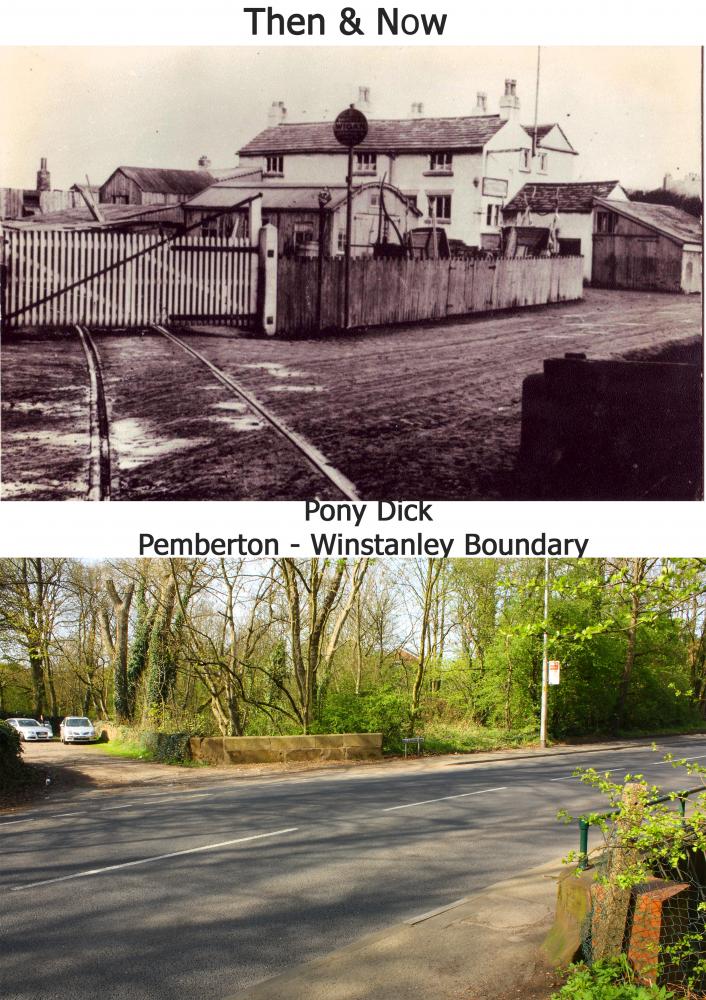
Photo: Ian Spencer
Item #: 17517
Brilliant set of pics, Ian. Thank you for that.
Is Pony Dick's grave still in the grounds of Winstanley Hall? Anyone got a picture, please? What, if anything, is happening with the Hall now?
Facinating picture. Is that the same wall that now has the rail on it?
Yes I think it is the same bridge, it has a name on the bridge 'Rylance Mill Bridge' I think the mill was through Blundell's wood somewhere and maybe used to be Ryland's Mill ? maybe someone can enlighten me and tell me the exact location ? There is so much history around this area and we just drive past as if nothing ever happened around here.
The mill which was a water mill was on the left hand side of the drive up to the hall, just out of the pic to the left. Gordon Cayzer and his mother used to live in the cottage by the side of where the mill was situated. You should find some reference to it in the notes by Ray Winstanley which are on "stuff". The road from Pony Dick to Enfield Street was known as Rylands Mill Lane, on the old ordnance survey maps of 1865
Thanks for the info Fred, will look it up.
please see comments on previous photo - these are not photos of the same place. The first photo is of the next bend towards Wigan and is now a housing estate. The second bend is in the dip and was the entrance to the Pony Dick drift mine I believe. The photos are approx half a mile apart.
please see comments on previous photo - these are not photos of the same place. The first photo is of the next bend towards Wigan and is now a housing estate. The second bend is in the dip and was the entrance to the Pony Dick drift mine I believe. The photos are approx half a mile apart.
There is a photo of Pony Dick's grave in "Founded on Coal".
The railway track on the old photo ran across the road from where the new photo was taken and went just to the left of the bus stop, between that and the road sign to the right of the bridge on the opposite side of the road.
I am not referring to any photographs - I spent my formative years in this exact spot. I believe the railway lines at the top belonged to the Venture pit whilst the ones you refer to did indeed belong to the Pony Dick colliery. There were lots of pits in this area with lots of railway lines, in fact Pemberton Colliery had 15 miles worth all to itself! I am not after brownie points but the photos are not the same and are not even looking in the same direction. Forget the reference books - go and have a look. The row of houses are the reference points to use as they still exist and are definately not the same being on opposite sides of the road.
I went up there yesterday to prove that I was right and everyone else was wrong ................... I ended up with egg on my face. I remember Winstanley (or thought I did ) from way before all the estates were built. I regularly visited all the farms in that area and Tan Pit Cottages when they were in the middle of nowhere. I thought I knew every inch but just shows how the memory can play tricks. Apologies to all.
Rylands Mill on Winstanley Estate used to be the boundary of the old UpHolland (St Thomas)parish about 100 years ago.