Wigan Album
Ince
25 Comments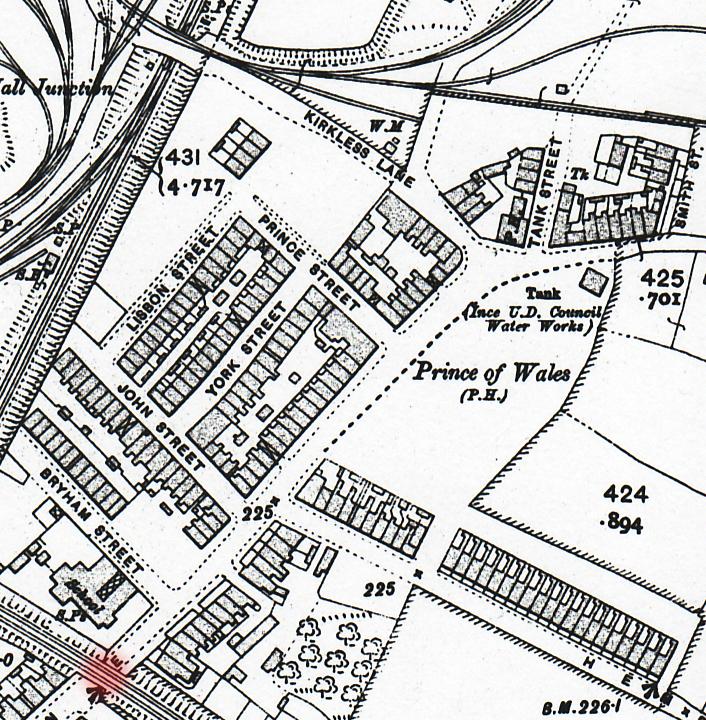
Photo: Gerry
Item #: 15362
Marlene I found a map with Smith St on.
Josie note Francis St is called John St on this map, you can also make out the outside pettys behind your houses too..
thanks gerry, thats the first time s ince leaving york st that i have seen anything like this and i thought the same about frances st dont get that? and although i didnt remember smith st i remembered mr and mrs cain living on that small row , on the map in york st the parts marked with an x were large entrys leading to all other streets and backs,on the right hand side of york st you will see a very small gap between the houses, this was a little narrow entry that lead to the backs of york st and bell green lane, we lived on the other side of york st backing on to lisbon st, its amazing to see this as i would love to see some photos of york st.
gerry ime here again,can you get a bigger area of top of lane map?there are some amazing things i have noticed that dont match with my childhood 1950, i know this map is about 30 years before and a lot can happen in 30 yrs but prince of wales is on other side of bell green lane, and the houses that joe mawdsley lived in arent there, also the bell vue pub is visible but not named on corner of tank st,also if you see the bit with the clump of trees was where we all played as kids it was known as the orchard apple trees and all ,let me know gerry about this map as i would love a copy x
the Belle View is not named but it is marked PH meaning Public House (this is map speak) The prince of wales was named on the other side of the road coz there was room to write it
Where do you get these old maps from, they are pretty well drawn.
we demolished the old bridge abutments in the 80's and adjacent was a section of iron railings which are now fixed to the wall of the Orwell at Wigan Pier useless information but maybe interesting to those from the area
Gerry - thanks for clearing up where the Prince of Wales pub was - when I first looked at the map - I assumed they had got it wrong, it was on the left.
Also just as you go to the top of B.G. Lane, and in particular the house on the left corner (shaped), my older brother George lived with his wife and 3 sons.
George use to pal around with Tommy Young.
Brings back memories - thanks for the pic -
Very interesting this map of the past, it's very well drawn. I remember the wood yard at the back of Lisbon Street, everyday you could hear saws cutting wood from the old Belle Green school. I can just about remember a little shop at the corner of York street.
Thanks Gerry.
When I were little Colin that shop were run by Minnie Johnson, opposite the shop was a Garage, they were always tikering with cars and had a fire going in a big oil drum. I beleive that garage used to be the Sally Army headquarters
can anyone remember the name of the small row of 4 houses on the corner of lisbon st and prince st,was it a continuation of lisbon st,i remember walking past the back of them they were on a brew going towards the white rd that led to canal.
Colin... copy and paste these links into your browser...
http://www.ecadfael.fu8.com/old_os_maps/wigan_1929_05.jpg
http://www.ecadfael.fu8.com/old_os_maps/kirkless_hall_&_hindley_hall_1907_01.jpg
They both cover the area of Belle Green Lane.
colin,i lived at number 9 york st and the shop was minnies,her husband was reg johnston, i remember women shopping there with babies in shawls with their little red (strap)books pay on friday ime not sure if it was barons saw mill that smell was delicious some folk in lisbon st had a pen that they had a shed and stuff including minnie and reg, i have a photo of my sister sandra in their pen with her best friend vivien johnson i will put it on here later,your school was a stones throw away from our house and i knew loads of kids from there but we were sent to st williams and walked it every day i remember always thinking how good it would be to go to bell green so close never thought it was all about religion? colin do you live in ince and do you have a sister called jean ?
... or a brother called Gordon?
Josie and Dennis, thanks for your comments. Yes I do have a sister Jean, and a brother Gordon, I was born a bred in Ince and lived there until I got married 1976.
Josie... can't remember the name of the houses, but the twins Robert and John Connelly lived in one of them with their parents, I think they had a sister as well. The twins later became professional Rugby League referees.
Thanks for the map Gerry i do remember York st. now, I was only about three when we moved from Smiths st. to Pennington Lane but one of my older brothers and my sister lived in Frances st when they wed and my oldest sister lived at the top of Belle Green Lane next to the school. I remember going to Minnies shop for penney tray on visits to my sisters, lovely memories.
Colin I worked with the Connolly Twins at Hawker Siddeleys As you say they were Refs and I think BOB still is, but John Packed it in, John used to live at Marus Bridge but now lives down at Stevenage with his second wife and twins Bob is still around Wigan area
marlean ime confused now? if you were only 2 when you left smith st you must be about 49 ish am i wrong but i remember a girl i thought was marlean who would be older than me i know its the same family but what were your brothers and sisters names?
Hi Josie your not far of i,m fifty one this time and my brothers and sisters names were Ethel, Teresa, James, Edward, Jack, Barry, Billy,and then me in that order hope this helps.
hi marlene, i left york st about 1962 when the houses were demolisned i was about 11/12 i dont think you would remember us i remember teresa and billy think hese my age 59 , thanks for info marlene.
Josie, billy Cain is aged around 53, he was in my class at the old Belle Green School. If you click onto schools then the 1962 photo with 11 comments, billy is on the 2nd row down, 3rd from the right. I can only remember Billy living at Pennington lane. Hi Marlene, how is Billy these days...not see him and others from the old school for years.
Hi Josie and Colin our Billy is fifty three he works at Wigan Infirmary and he,s fine and believe it or not moved back to Pennington Lane some years ago different house though.
Baron's saw mill was at the end of Hemfield Road. I lived in 27 Hemfield Road with my Grandma. I remember playing with Harold Baron and some of the other kids from around Hemfield Road.
Great to see this old map. My mum (who is still going strong) was born at 7 York Street in 1926. The family later moved to 6 Hemfield Road. The only picture of York Street I've seen on here is of the Salvation Army Mission (that my mum remembers, my grandma used to make potato pie for them). If anyone has any other photos I'd love to see them.