Wigan Album
Douglas Terrace
8 Comments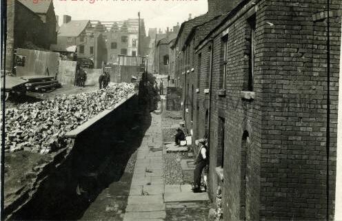
Photo: Veronica B
Item #: 35769
What is there now, Veronica, where the terraced row stood, please? I can't get my bearings on this one.
I think it’s mostly trees and tall flats Irene but I’m probably wrong.
The pathway in front of the houses more or less is what was the entry which ran between the back of the RIitz and came out at the side of M&S. The back of these houses was on Crompton Street. The River Douglas ran more or less where the photographer is stood It was diverted when they built the CENTRAL STATION. If you look at the side of the Spiritualist Church on Crompton St. You can see the wall of the original River Douglas bridge. There was a similar wall on the opposite side of Crompton Street. Which was demolished to make way for the Galleries. I'm sure there are photographs of the bridge brickwork on here somewhere?
Which direction would Standishgate be in relation to this photo?
This is where the
‘ topographers’ come in Irene. You know who they are…
I remember the passage way at the side of the Ritz where it came out near Marks. I was way out! I didn’t realise the houses on the photo were that far up. Do you know the date of the photo Ron?
Ron, I think you are spot on with your location and description and I do remember that remnant of the stone walled Douglas Bridge very well.
Perhaps the back of those tall buildings in the distance which look to be in the process of being demolished are to make way for a new Pendlebury’s Department Store which itself was gutted by fire in the early 1950’s.
You could still walk up that path from Watkin Street / Crompton Street to Standishgate right up to when the Ritz was demolished and come out at the side of Debenhams.
The Standishgate entrance is still there but blocked off with a locked door. I often look at that door and think of the many times I have walked up and down that path.
Rich, the 3 story properties would be on Standishgate where Pendleburys store was.