Wigan Album
Chapel Lane, Wigan
8 Comments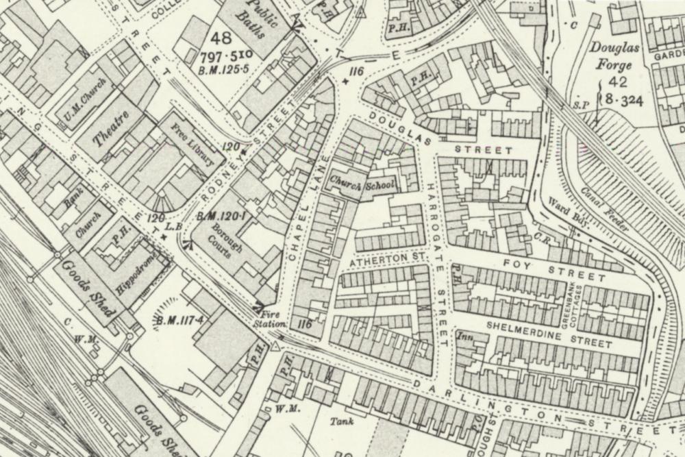
Photo: Rev David Long
Item #: 33378
The school at the back of the church is where my maternal grandmother attended. She lived on Darlington St at number 4. The school became Wigan Agencies my mother bought clothes from there and that's how I know she went to the school. I remember going inside in the fifties. I remember wood and glass partitions, the church was a grey stone colour. I was always familiar with that area. School friend lived in Shelmerdine St. Interesting.
comparing the buildings on the map and the date of 1876 the chapel in the photo Ron put on and the date of 1877 when this chapel was built I the older chapel couldn't have been the same location, unless the newer one was built around the older, which they often did.
In the late 1960s when I worked at the Co-op the garage was on Foy Street and we'd often call for fuel and a brew, I recall a shop being across the road where I'd go for Kit Kats, I don't know how old the lady who had the shop was but she looked ancient and would come shuffling in from the back as you walked in and the bell rang, I can remember with the décor etc. it was like stepping back in time except for the modern sweet jars and chocolate wrappers.
Never knew the road from Foy St to Shelmerdine St was Greenbank Cottage, though in the late 1960s a lot of the properties around had been or were in the process of being demolished, I've found this photo on the Album and taken from Foy Street, I was looking for the name of the pub that was at the top which I couldn't remember, it was The Adelphi. https://www.wiganworld.co.uk/album/photo.php?opt=4&id=6257&gallery=Harrogate+Street&page=3
Wasn’t the goods shed in the centre a banana warehouse at one time? Also a number of wagon turntables visible. Very interesting map.
Stanley, Yes, the goods shed on the left was until the early 1960s,
a ripening room for Ffyffes Bananas. I believe that in its very early
days it was a goods shed for receiving goods from all over the UK
and delivering them locally. Also, local goods could be sent there
and sent on throughout the country. From about 1964/1965, it was
a road transport depot for Robert Baillie & Co Ltd from Portsmouth.
It was my place of work as an HGV driver for 3 years from early 1970.
Have a look on here at the Robert Baillie section to view the building.
Cheers, Ray.
Does anyone have knowledge of any other church, of being of the same religious persuasion as the church being commented upon, in any part of Chapel Lane?. The only other large building that I can recollect, was the. R.A.F.A. Club, I believe it was on the corner of Queen Street.
I see Rodney St on the map. I remember my Bradshaw family mentioning Rodney St Chapel being the main chapel of the one they attended, it was off Billinge Rd, Pemberton.... near Alexandra Park which was demolished a few years ago.
Does anyone have knowledge of any other church, of being of the same religious persuasion as the church being commented upon, in any part of Chapel Lane?. The only other large building that I can recollect, was the. R.A.F.A. Club, I believe it was on the corner of Queen Street.