Login   |   Register   |   
Photos of Wigan
Photos of Wigan


Wigan Album

Wigan Map circa 1850

13 Comments
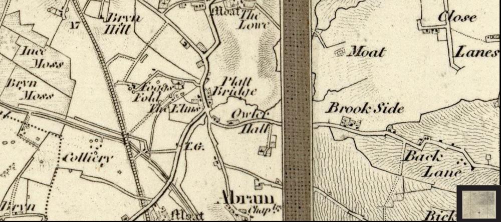
Wigan Map showing Platt Bridge circa 1850's.
Photo: Ken
Views: 2,907
Item #: 23655
Wigwann's request - Platt Bridge and environs, circa 1850's, from same source as previous Wigan map.

Comment by: irene roberts on 1st July 2013 at 13:09

What do the initials TG stand for, shown a little below The Elms? Anyone know?

Comment by: Phil Taylor on 1st July 2013 at 15:14

I think TG stands for Toll Gate.

Comment by: J K on 1st July 2013 at 15:25

Toll Gate ?

Comment by: wanner on 1st July 2013 at 16:03

I think its Toll Gate Irene

Comment by: Eddie p on 1st July 2013 at 16:05

TG toll gate I would think

Comment by: Jimmy on 1st July 2013 at 16:09

TG means Toll Gate Irene

Comment by: irene roberts on 1st July 2013 at 16:26

Thanks everyone.

Comment by: Albert. on 2nd July 2013 at 10:42

Irene. I think ,without a doubt, we can now safely say, it means toll gate. I didn't know what it referred to.

Comment by: Jimmy on 2nd July 2013 at 13:34

You can see the ordnance survey abbreviations on this site.
http://www.ordnancesurvey.co.uk/oswebsite/aboutus/reports/misc/abbreviations.html

Comment by: Wigwann on 2nd July 2013 at 20:38

Many thanks Ken, you can always rely on WW readers for help.

Comment by: Joe on 2nd July 2013 at 23:25

There is a TOLL STREET in PLATT BRIDGE off LILLY LANE just after HOLY FAMILY PARISH HALL.

Comment by: irene roberts on 3rd July 2013 at 10:35

You're right, Joe. I know Toll Street well.....I just never connected it with a Toll Gate.

Comment by: Owdjem on 3rd July 2013 at 11:58

If you zoom in on the map you can see a line drawn across the road at the toll gate point.

Leave a comment?

* Enter the 5 digit code to the right of the input box. Don't worry if you make a mistake, you will get another chance. Your comments won't be lost.