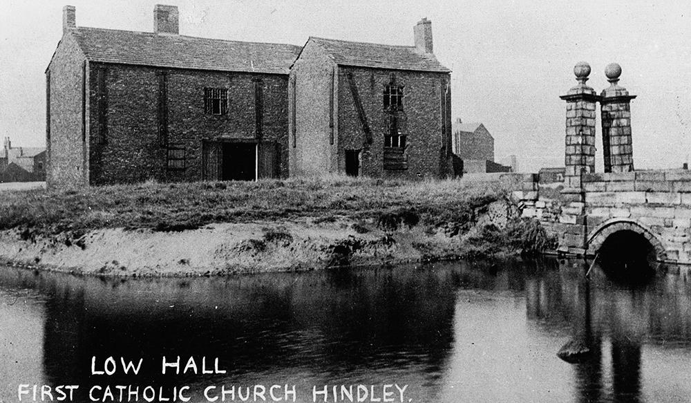
Wigan Album
Platt Bridge
16 Comments
Photo: Dennis Miller
Item #: 22007
One again I have to thank Pam for this photograph.
great historical photo - thanks for publishing.
Dennis you understand the photos much better than I do and you can make them look better than I could. Is this the Low Hall that Steve mentions at the back of my grandmas house behind Liverpool road?
It is Pam, some maps have it as Low Hall, some as Lowe Hall.
Amazing picture Dennis,when I was a kid in Mrs.Ashtons class in St.Nats this moat was at the bottom of her garden.Where the new estate now stands,she asked me, Ernie Brooks,and Dennis Redford to go fishing there after school to see iff there were any fish in the moat,we fished for about three hours,never got a bite,I remember it also never stopped raining this would be in the mid fifties,Mrs. Ashton lived on Liverpool Rd.
John you may not have caught any fish in the moat, but when we where kids we caught loads of great crested newts in there! Happy days!
Dennis A Roman Catholic mission was established at Lowe Hall in 1727.It moved to Strangeways Hall in 1773.In 1789 a chapel, the first St Benedicts was built in what is now Market St until 1869 when the present church was opened
Could the building to the right of the hall be the low hall inn that was in Lymn st.?
Steve... thanks for the info. So it would seem the caption is saying it WAS the first RC Church at one time, rather than the time of the photograph... which brings me to...
Wanner, it is more likely the roof of the Low Hall Infants school. The other photograph is dated 1872, but this photograph is a lot later... the windows are boarded up and it looks derelict, it is possible the infant school was in existence at when the photo was taken, the school was behind the methodist chapel across from Lymn Street
I think you may be right Wanner,it certainly looks like it,the building on the left is on Liverpool Rd.I would say,if Dennis could post the map from 1893 on it would show the exact location and the surrounding building,when I was a kid in the fifties the ruins were still there,we also thouught it was haunted,but then again we also believed in the murder bridge just across from the old barn,I think every district had a murder bridge back in the day.
I lived next door to the the low hall inn for over 20 yrs so that gable end became very familiar. But not knowing the direction of were the hall was facing I have to take Dennis word if he has info that says different.
Dennis where would I get hold of these maps?
Great photo BTW
Be warned these maps are massive, they are all single sheets showing practically all the Hindley and Abram area over 9 sheets... each one will take a while to display in your browser, but you can then download them. They are all from 1893. Just click on the filenames in the list to open them.
I have to thank the gentleman who sent them to me, he knows who he is.
Senior moment... forgot to post the link!
http://www.ecadfael.fu8.com/os_maps/1893/
Just a bit more imformation on this amazing photo,the house to the right of the main building is No 539 Liverpool Rd.in the distance is what I believe to be the Low Hall public house,as mooted by Wanner,regarding the building to the left,I am of the opinion that it is the bottom end of Barton St.For anyone interested in the history of Platt Bridge this really is an amazing photo.
Thanks so much for posting this, cross referencing the photo with a map of 1893 also posted on WW, this photo is taken from the very spot where my house stands! We had an extension a few years ago and the builder said that the house was built on floating foundations - it make sense now as most of the house is built in what was a moat!
love pics and comments on lowe hall, heard there was a large tapestry sent to worsley old hall, is there any truth in this and if so where is it now?