Wigan Album
Lower Ince
17 Comments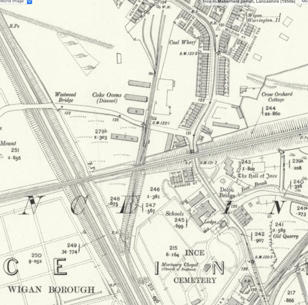
Photo: Rev David Long
Item #: 33011
I can't remember the name of the monumental masons shop that became Varty's, though on the map at the back of where is situated is an old quarry, I'm wondering if it was from there the original stone masons got the stone for the cemetery headstones and memorials that was made and sold there, and according to Wiki the stone that was quarried from Ince was also used to build the railway bridges around there, I also never knew that Ince came from the Welsh name for dry land ynys.
Interesting too about the old van hire garage with the mine shaft in the yard with houses now built on the land, makes one wonder how they got mortgages on the houses, because a potential buyer was refused a mortgage on a house about half a mile away because there was a mine shaft within 60 metres of the property, it was in the front garden of the house next door but one and was deemed too much a risk by the building society. I thought this a bit strange as the old adage that says you are never more than 6 feet from a rat could be rearranged to describe the land around Wigan and District; by replacing rats for pits.
Can remember a black and white foot bridge there when I was a kid (70s).. think it was just kind of on the ground... No sure if it got moved down poolstock area some where, could be wrong... cheers
I suppose it depends how the old pit shafts are dealt with. The other shaft for that pit - which isn't marked on the map at all - is a few yards away on a plot of land on the corner of Banner Street and Deakin Street - and is marked by a concrete cone.
The coal authority came to examine subsidence on the opposite side of the line from the garage - they drilled to discover if an unmarked pit was there, but found nothing. Their map of known pits in the area showed it was pock-marked with them - but many will have been shallow and no problem now.
Flats are soon to be built on Almond Brook Road, which will be put on the site of a pair of Council houses which I had been told had to be demolished because of mining subsidence. But they've done test drills... so I suppose it's safe.
How can there be a 'wharf' where there is no water?
Wasn’t it Cowarps grocery shop that was just around the corner from Westwood Lane, on Warrington Road?.
Dr Duffy’s, Ince surgery was at the bottom of Burgess Street. He used to park his Jowett Javelin car outside, when he was at the surgery. I was only a school lad.
I don’t know if the St. Mary’s Vicarage is still on the other side of Westwood bridge, but it was in the sixties.
St Mary's Vicarage has been in a number of buildings over the life of the Parish - but is now next door to the present church, on the site of the original Hall of Ince School.
I'll submit a map of the upper end of Westwood Lane, with further information.
I've heard about those houses on Almond Brook Road and also another two on Greenwood Road Standish that also collapsed due to a mining. I've also heard that some of the new build houses on the sites of Cat I'th' Window and Robin Hill Farm fields are now having problems with mining subsidence and having to be underpinned, Some years ago part of a field on Robin Hill farm collapsed into an old mine tunnel, and Bob the farmer had luckily just finished ploughing that field too. It's strange that these big building firms hadn't known about the history of past mining around there before building, unless like at Almond Brook the test drills here had also been okay when the fields were surveyed.
St Mary's vicarage was still on Westwood Lane in the 1970s Albert, as I had to call there to pay wedding fees, I'm sure it was the same house that was for sale recently. https://www.onthemarket.com/details/9005872/
Reverend Long will know Cyril, about the previous vicarage.
Coal Wharf is possibly from Old English word 'Wharft' which had evolved into meaning 'Yard'.
So Coal Wharf would be Coal Yard.
I remember seeing the embedded tracks as described a good few years ago, I’ve been trying to rediscover them during lockdown wanderings, a total fools errand it transpires! Ditto the old turntable near Britannia Bridge. All traces seem to have been obliterated, unless of course someone knows different.......?
What type of turntable are you referring to?. The Latte Lad.
The only one that I can remember was at the Spring’s Branch railway sheds.
Come to think of it The Latte Lad. I do believe there was a turntable within the L.N.E.R. Railway Sheds. Situated just beyond Winifred Street, and Carter Street.
An aerial photo of that part of Lower Ince on the Album under Darlington Street, shows a turntable on the said railway at the rear of Westwood Motors middle far right on the photo, don't know if this is the turntable in question. Link below.
https://www.wiganworld.co.uk/album/photo.php?opt=4&id=29669&gallery=Darlington+Street&page=1
That’s the one Cyril! Interestingly the outline of Westwood Motors on the photo more or less mirrors the present day site of Beesley & Fildes. I’ve had a good poke round but It’s difficult to get the exact track alignment on the ground, looking from the canal towards the bridge and heading to Lwr Ince station . I think the turntable would be to the left of the track bed looking towards Ince?
There are photographs of that line in 1950 on timepix.co.uk