Wigan Album
Camel's Hump and Coppull Lane
24 Comments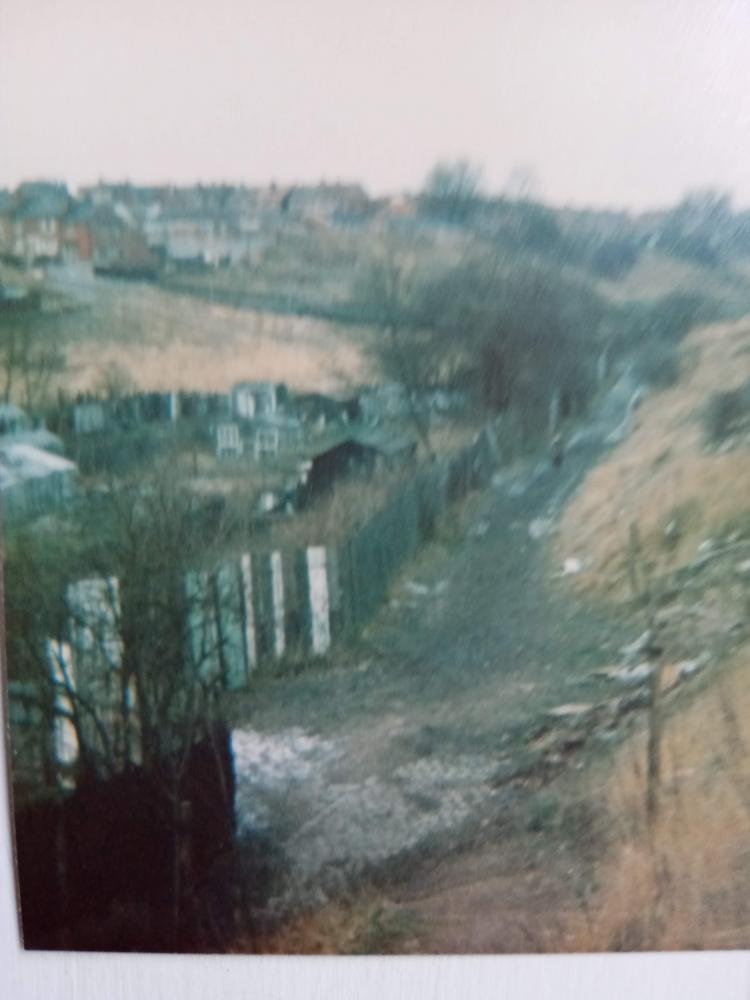
Photo: Halliday E
Item #: 32969
I must say I don't remember the area with the wooden planks around. It looks like a 'garden' has been made it an allotment?
Guess what!! Thats me on the path, in the 60s.This is now were you would walk to Tesco at Central Park.Thank you Veronica xx
It is blurry Edna, but I can make out the whereabouts, it'll be twenty odd years that I was last along there walking dogs, and it was quite overgrown with Brambles and Gorse along the sides of the hill and not clear like then.
On a map of 1907 it looks as though a few allotments were behind St George's school.
It is a lot blurry but nevertheless a great photo of a long gone scene. I can just make out the side of the old Swinley Labour Club at the rear of the last house on Coppull Lane. Ted Lloyd and his family lived in that house. Ted also had an allottment at the side of the River Douglas roundabout where this allotment in the photo is. .
Yes Veronica and Cyril.They were allotments, its were my dad took me every Sunday, for cabbage carrots and flowers, in the early 50s.
I remember the Lloyd family living there.
I remember those allotments, is that the bottom of the camel's Hump on the right?
Probably not the same family Ian, but in the 1990s the family at the last house on Coppull Lane had a young Collie who was a character, he would hide behind the gate post when he saw anyone coming down the hill and when they'd reached the gateway would leap out and gently nip the ankle of the person going past, he wasn't being nasty just playful and always gave the recipient a bit of a scare, a lot of folks took it in good spirit, but someone complained and his fun was stopped with him being kept in, shame really as he did enjoy himself and would have grown out of doing it in time.
I learned to call allotments 'pens' when I went to Lower Ince. Is that not the universal Wigan term for them?
This place looks a lot less attractive than the idyll folk claimed was lost by the construction of the dam....
The fifties and early sixties were the heyday of that area. The Camel's Hump was a grassy area, just made for roly- polling, as was the flat land before Coppull Lane. It looks like Winter has turned the land to scrub. I don't remember the allotment at all. Looks as if someone had 'claimed' that land.
The idyllic area was on the other side of Coppull Lane and beyond the dam and which now floods during heavy rain, the area was also decimated in the 1980s when the council brought in Scrapers to level the land, this destroyed the natural wild meadow plants that thrived around there, nature did grow back but was mostly grass and scrub.
I'd always assumed that the term Pen was the place where the occupiers kept hens alongside their growing of fruit and vegetables, and allotment was just growing fruit and vegetables. Maybe the term Pen just carried on being used, someone may know different. You also still need permission to keep hens on Wigan council allotments. https://issuu.com/wlct/docs/wlct_allotments-guide
This view is from the top of the 'Woodyard steps'.
The pens also had some pigeon fanciers.
This was one of the routes home to Bottling from Wigan although the favoured route was up the Woodyard steps along the footpath to the bottom of Pike Street.
The slope on the right levelled off just out of picture and St Georges football pitch extended to
the bottom of camels hump.
This pitch must have been the worst ever because water drained across it from the hump to the footpath in the picture and the water flow cut small ditches across the playing area also when the ball went in touch it finished down there on the footpath.
T
You have explained that very well Graham. I have found my bearings now. It was the other side were you walked to the woods at the side of the river. As you say the Camel's Hump was quite a bit further on. The Woodyard (Calderbanks) was nearer to Greenough St if I'm correct. Thanks.
If you walk to the right of the photo Veronica, you will come to the steps, that are still there, which brings you to the bottom of Great Acre.Houses are now built on the camel's hump.Its called Fellside, and Rowan Hill.
Ah! I never went that way Edna, we went by Greenough St at the side of the smelly urinals, that's why I don't recognise it. We always walked down the side of the 'Duggie' near the stone wall, there were some stone steps also, then past St George's and carried on by the flat land where the lads used to play football. A bit further on was The Camel's Hump it was grassy and just right for rolly - pollying.
The collie dog that you mention Cyril would most likely have been Benjy. Long gone now of course, but I remember him well. I have no recollection of him nipping anyone, but as you say, he was a proper character.
In his later years, he was often allowed to roam freely and could frequently be seen rooting about on the field at the bottom of Coppull lane.
It's good to learn that he hasn't been forgotten.
Ozy, I remember the collie dog.It always seemed well behaved to me.
The son murdered his mother in the bottom house on Coppull Lane. Not sure of the date, 50s/60s
The wood yard belonged to Ashcrofts
I stand corrected, I don't know where 'Calderbank' came from! (My brother worked there for a very short time when he left school).
Calderbanks was the scrap yard just off Greenhough St. Veronica.
Thank you Ken... I was wondering where I had got the name from! Names do stick in the memory even when they can't be placed. I do remember Ashcrofts though.
The reason you remember Calderbanks Veebs may possibly be that this could well have been the place where thi yed geet fast i't railings, eh? What do you reckon?
No that's not it Ozy, the place my head got stuck was where Water Heyes was, on a Sunday walk I was only 5. I won't forget that in a hurry...