Wigan Album
Ince
21 Comments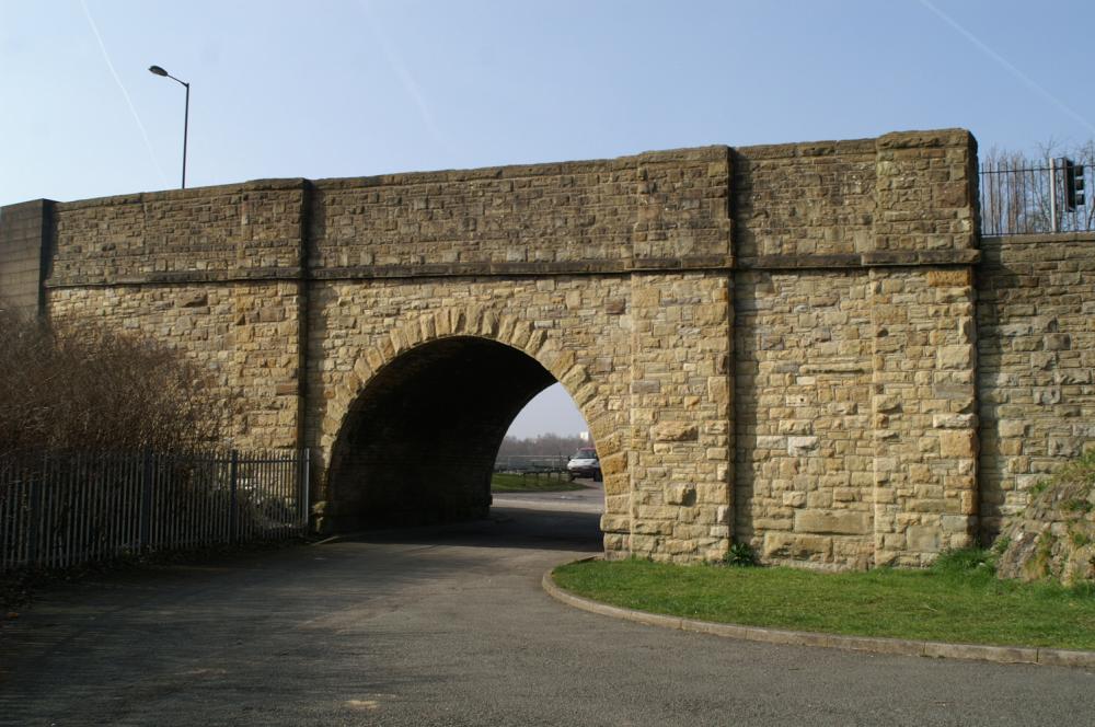
Photo: Rev David Long
Item #: 27149
It also when under the now filled in railway bridge. Behind you Rev Long. You can still see the railway bridge safety barriers.
Interesting. I was aware that there was an arm of the canal that went off in that direction, but I never realised that it extended beyond Ince Green lane and it never occurred to me to question the reason for the arch.
Looking towards the Long arm,as it was called from the short arm!
The branch of the canal that came over to this side of the church bridge was known locally as "th'owd arm".
Ive rode my bike under this bridge and always thought it was a railway bridge with the railway line being so close.
Next time Im down there I will have a better look at it.
An easier way to get from one side of the road to the other, without climbing all the steps, and then down the steps on the other side.Especially if you were going to the Conquering Hero pub.
I remember that road being muddy, now it's been tar-macked.
Does it serve a purpose today?
when was this canal filled in.
I'm not sure that it was 'filled in' as a deliberate one-off action. It fell into disuse, and gradually silted up - the track from just beyond the vehicles in the pic can still be traced by the trees which have grown in the canal bed. It's been said that there used to be a dirt track through the bridge - so I suspect it gradually got filled in with tipping. Then perhaps the creation of the playing fields between the canal and the railway led to this section being flattened out. I suspect the area on the other side of the railway, where the Viaducts had been, was filled in when the Council houses were built - perhaps with the remains of the houses which once stood beside the canal.
My 1930s map shows it in water from the canal up to the bridge, but dry beyond - which fits with my suppositions.
I had a ride down there this afternoon and although I hadn't noticed it previously, now that the foliage has died back it is plain to see that there is quite a long section running alongside the back fences of the council properties. Also with the recent heavy rainfall, it actually resembles a canal. Not the Canal du Midi exactly, but obviously not a natural phenomenon either. As it approaches the main canal it makes a turn to the west under the metal footbridge, which I had previously thought crossed a natural stream, to emerge just below the bye wash of the lock. As I stated previously. Interesting.
The Rev David is right ,the long arm silted up and disappeared when William Foster playing fields were created! I remember the shells of old barges rotting away at the Canal end!
Irene is probably right about owd arm but people put different names to all sorts of things,but I remember the fire brigade pumping out the little arm looking for stolen goods,as if people from round the viaducts would do anything like that.
I think that stretch of water was about 10 yards wide and 40 yards in length and was filled in when the little viaducts were demolished.
I will ask Eric Lowe about it when I next see him,he lived there.
great picture and comments.
What we need is for Mick to go down there on his futuristic bike and take a picture for Photo-a-day.
Yes the canal used to run past the front of the Houses in the Viadocks.
with regards the canal going under the bridge if you look at the road coming down from whittaker old shop now for sale mar thelens as we called it you can still see a slight depression where the road has sunk a little where the canal flowed originally i lived in farmer st incidentally next to betty and jack foster
Went to ride my bike on canal tow path could not , too many walkers who has right of way on canal tow path it's not a cycle lane
My wife lived in Canal Street as a little girl. This street was actually houses built along the old tow path of the canal. See my own photos etc here. https://www.wiganworld.co.uk/streets/street.php?az=c&street=624
By the way if you look at the old map in my post you can see there was once a footbridge over the canal leading to an inn called the Railway Inn. If you look at the photo showing the canal bridge there is a wooden stump in front of the red car. This stump is more than likely a remnant of the old foot bridge as it is exactly where the footbridge was located on the bank of the canal.
See my recent posting and photos of this area here. https://www.wiganworld.co.uk/album/photo.php?opt=5&id=27149
My wife lived in Canal Street which once stood at the other side of the canal bridge. if you look at the old map at the link above, you will see there was once a footbridge over the canal too leading to an inn (Railway Inn). The wooden stump in front of the red car in my photo of the canal bridge is exactly where the footbridge was located, so likely to be a remnant of it.
Have a look at the following side by side interactive map and satellite image at the link below that show exactly where now gone features in the area once were.
https://maps.nls.uk/geo/explore/side-by-side/swipe/#zoom=19.4&lat=53.5392&lon=-2.6107&layers=117746211&right=ESRIWorld
Most of the canal system is Listed - but, although this bridge is about 200 years old, and carries the rope marks from its days as a working branch of the Leeds & Liverpool, my understanding is that it is not Listed... and will probably be swept away when the adjacent railway bridge is replaced as part of the electrification scheme.
Another interesting feature of Canal Street was that originally there were only 5 houses and they all had even numbers 2 to 10 as can be seen from the 1891 Census transcript available online. Sometime between 1891 and 1901 another house was added which was number 12 where my wife and her family lived from 1966/67 until the houses were demolished in the early 1980's due to the land beneath them becoming unstable. This interactive side by side map link shows the original 5 houses. https://maps.nls.uk/geo/explore/side-by-side/#zoom=18.6&lat=53.53942&lon=-2.61144&layers=117746211&right=ESRIWorld
This post 1900 interactive map is interesting. It shows that where the houses now stand on The Grove, once stood a football ground next to the Ince Hall canal branch.
https://maps.nls.uk/geo/explore/side-by-side/#zoom=18.2&lat=53.54004&lon=-2.61155&layers=168&right=ESRIWorld
On Easter Sunday, I walked through the entrance gates to Foster's playing fields and along the path behind the houses on The Grove. I was delighted to see that there is still water in many parts of the old Ince Hall branch if you look through the bushes on your right hand side.