Wigan Album
Ince
27 Comments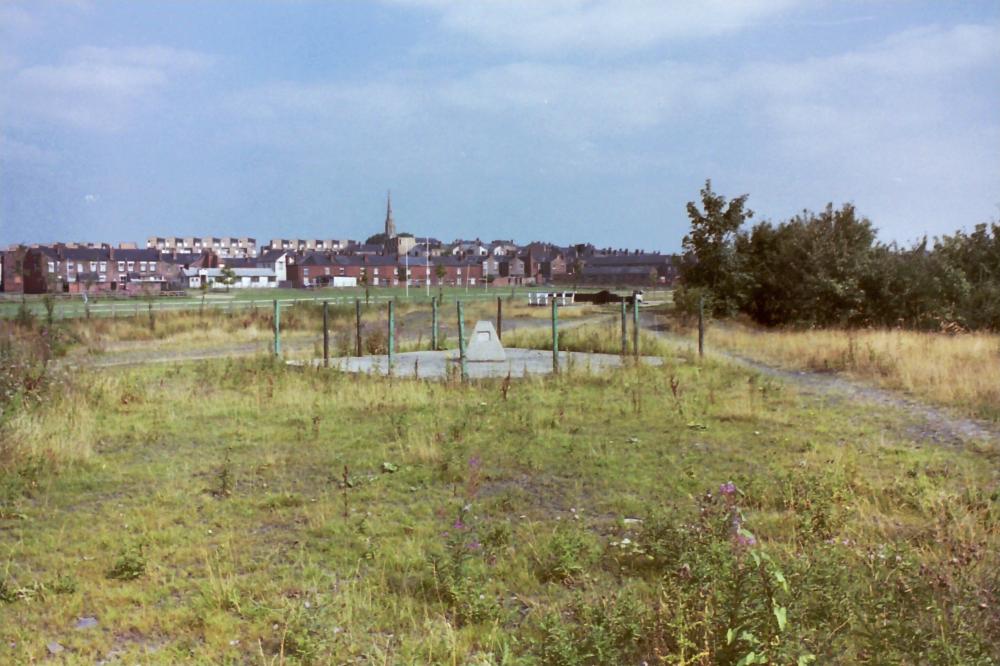
Photo: terry almond
Item #: 24784
When was this taken Terry? St Catherine's spire looks out of vertical unless it is an optical illusion because of the rugby posts on St Pat's pitch. Is that a capped pit shaft in the foreground?
Sorry Terry can now see 1983, silly me.
photo taken from William foster play fields over canal from st pats
This looks to be the same pit shaft cap as seen in the earlier one we'd thought of as being on Ince Moss - it's quite plainly alongside the canal, with St Pat's rugby field across the canal from the lock. So the earlier pic we'd been discussing looks as if it were taken from around the same area, looking west.
This pit appears to belong to what was the 'Lower Coal Works'
and is adjacent to Whaley's Basin. The canal lock in the distance should be no. 17 or 18. So it isn't an Ince Moss pit after all.
Hadn’t a clue until the postings pointed me in the right direction. Here for what it’s worth is how I now read the lie of the land from left to right, Ascroft Street, then the old canteen now the re-built headquarters of the famous St Patrick’s Rugby Club, then Harper Street, and finally what should have been Clarington Grove leading down to the canal, now removed and what looks like a factory of some kind possibly a Mill that existed between what was Clarington Grove and Chatham Street and Henry Park Street. At the bottom of Clarington Grove, next to the canal on the opposite side there were no houses but there was a pub,(shown on 1907 Wigan ordnance survey maps) I wonder if anyone knows what it was called, I have never seen any photos of it.
This shaft was one of three and was the Ince Hall Collieries
In the forties they were open with walls around the top and as lads we used to lob bricks over the walls and count until we heard the " Bedosh" as they hit the water at the bottom of the shaft. There is some sketches of Ince Hall Collieries about, with St Catherines and St Pats in the background As in this photo.
There was also a "Birkett" Colliery (no doubt named after the nearby Birkett Bank) sometime in the 19th century, owned by one of the big mine owners John Lancaster - it was located somewhere very close to Chatham Street and Henry Park Street.
You can see the "Upside down houses" to the left of St Catherine's
Is the capped-off shaft still visible today and if so, how would you get to it?
Behind the goal posts is Harper St. Look carefully and you'll see a different shade of bricks. I think this is due to bomb damage from a Zeppelin raid ?
We'll spotted Ged - the first change in brick colour is no.27 Harper Street, the house my grandmother to be, Annie Gorrie aged 18, was living with her family when the house had its windows blown out, the family pet killed and two next door neighbours killed by the Zeppelin bombing of 1918.
Irene, you could walk down The Grove and access William Foster playing fields and head towards the canal bearing left and you would come to the capped off shaft. This area was a wood dump during the 2nd world war. I lived in Kingsway and we used to go across and "liberate" some timber to make rafts to sail on the Long Arm as it was known which was behind the houses on The Grove. On VE night several of the men raided the dump for timber to make a massive bonfire on the land behind Kingsway. What memories.
Alan H, many thanks. I asked on behalf of a friend of mine. We have been over that area a couple of times but never come across the capped-off shaft. I just wondered if it was still visible today as the photo was taken thirty years ago and I thought it may now be grown over. My friend and I have looked in vain over that area for capped-off shafts. We will try again if you can confirm it is still visible today.
Was this area known as The Kemmick, or Chemick? If so,as a lad, I crossed this field, from Ince Green Lane, many times, in the forties, and early fifties. When I reached the canal I jumped across the by-wash, that ran by the side of the locks. My uncle lived in Harper Street.
The Kimmeck was adjacent to the next lock and on the other side of the Long Arm ( Whalleys Basin) it was a black piece of ground on which nothing grew,On the old Wigan maps it is shown as " Site of Chemicl Works." They still built on it and I believe various problems were later repoted
Irene, sorry, I can't confirm if the capped off shaft is still visible. I have lived in Standish for 50 years so I don't know what is left of the area. A few years ago the council had to dig some gardens up in Kingsway where I used to live and remove about 3 feet of soil because it was found to be contaminated. The house I was born in, number 5 and the house next door ,number 3 , were demolished about 10 years ago due to subsidence.
Thanks Alan H. I thought you lived in Ince. I worked in Standish over 40 years ago in Richardson's Chemists when it first opened.
Alan.H. When you lived in King's Way, did you know a family named Glaze? I do believe they lived in that road.
Albert, forgive me for nosing, but I remember Mr. and Mrs. Glaze. They knew my Mam and Dad.
Thank you Irene. Mr Glaze was,Sam, Mrs Glaze was, Rosie. I mated with their eldest son, Alan, we were friends since St Mary's Infants' School. He is on one of the school photographs that I have just put on. Norman still lives in Higher Ince. (Ince Bar).Sam is still around, but I don't know where he lives. Sylvia lives somewhere in Horwich. Sadly Alan passed away about twelve months ago.
Albert, there was a family called Glaze who lived in the new part of Greenfield Avenue. My memory is a bit hazy but I seem to remember they had a son and daughter.That would be about 1950 Did you know PC Alan Cotton?
Sorry ,Albert , I now see that you answered my query re Alan Cotton on another page. Thanks.
albert.the area you know as the chemic was originally called the chemical fields, shortened to the chemic, years ago there was a chemical works on that land, as a b pointed outproblems arose years later, the council had to replace all the soilfrom all the gardens in the grove and surrounding areas because traces of the chemicals had been found.
Harper St straight across.Was born in No 29 1940.Graandma lived there until about 1967
Went to try and find this shaft today. Think everything has been covered over now
keith the street at the left of houses was hartley ave i was born in harper st ashcroft st was off little canbridge st not on map