Wigan Album
Ince
15 Comments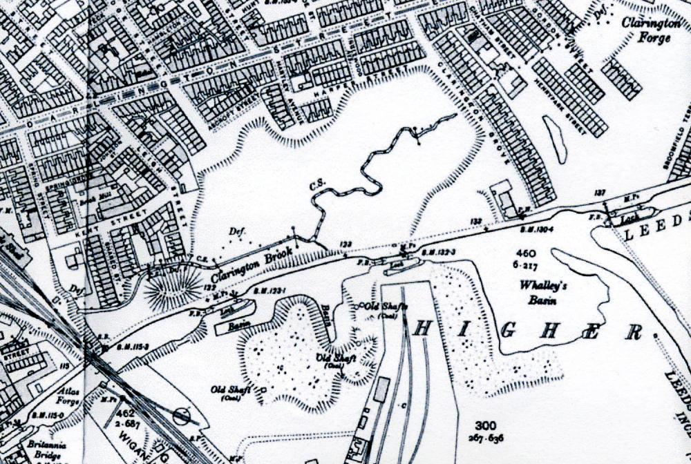
Photo: j greene
Item #: 16527
where did/does Clarrington Brook start & finish?
& what was the purpose of Whalleys basin?
you can see Whalleys Houses on the 1908 map on this site
http://www.old-maps.co.uk/maps.html
In Mike Clark's excellent History & guide to the Leeds & Liverpool Canal is printed (page 199) a section of the 1840s OS map showing this area. It shows the area before Darlington Street and the streets off it were built, when Hardybutts and Birkett Bank was the route out towards Manchester. There was no Clarington Grove - and no pub by the canal. Whalley's Basin is shown as a more structured offshoot of the main line of the canal, with a dock, rather than the open expanse of water seen here - which may be the result of subsidence. At the southern end of the spur is marked an engine, and there are also some houses marked. No name is given for any of the pits, but it states 'Ince Hall Coal & Cannel Company Colliery'. If anyone wants a scan of the section, just email.
My mother (b.1919) and grandmother (b.1898) lived in Clarington Grove (the Ince end, nearer the canal) and I don't remember hearing about any pub in the Grove, and yet I too am intrigued by this map and the fact there was a pub there. Unfortunately neither are around to ask. I'd also like to know the exact location of Birkett Bank Colliery which was somewhere on this map, perhaps nearer to Chatham Street.
Birkett Bank Colliery is marked on the 1840s map I mentioned above. It was beside the Clarington Brook, just south of where Gordon Street meets Darlington Street East.
Thanks for that David.
The Leeds and Liverpool Canal was'nt intended to go through Wigan at all,the original route was miles away,I don't know why the route was changed though,if I can find it I have a map of the proposed route.
Mike Clark's book cover the subject in full. Briefly, the final line was driven by commercial decisions - the most direct route, by-passing Wigan to the North, brought little traffic to the canal, whereas going via Wigan allowed it to carry its coal west to Liverpool, and east into Lancashire.
Thanks for the info David,you learn a little every day,trouble is you soon forget it.I found the map,so I will put it on here.
Thanks for your comments. I have looked at old-maps.co.uk and think that Whalleys Old Colliery Cottages may have been nearer to Brittania Bridge. On 1881 census they are listed after Brookside (which may have been the previous name of Boundary Street, off Warrington Lane) and "Patricroft Inn" which may have been one of the cluster of pubs around the Brittania Bridge.
Under "ince" in this Album you'll fimnd a pic taken in Brookside, Ince. Someone asked where it was in the Comments, but no reply was given... but it doesn't look like Boundary Street, off Warrington Lane. I've always thought the Brook it related to was the Ince Brook at Manchester Road... but someone will know better.
The pubs at Britannia Bridge on the 1840s map were the Britannia and the Navigation. The Shepherds Arms obviously came later, but it's not listed in Worralls 1881 Directory. What was the name of the grandfather you're after?
Rev Long, if you look on www.old-maps.co.uk at 1890 Town Plan of Wigan, then just down from Brittania Bridge, first street off on R going toward Wigan is Brookside. My great-grandfather was Thomas McSorley. His own great-grandfather James McSorley was married in All Saints Wigan in 1794. Thomas's father took his family to Bolton where unfortunately Thomas's baby brother and sister died, followed by his parents. His aunt, Ellen Baxendon took him and his sister back to live with her in Wigan at Whalley's cottages.
My grandad lived at no 2 brookside, which ran parallel to Manchester road between the old Star pub and Island row where I was born, The old white cottages on the left when you go to morrisons at Ince are Island Row
Thanks for extending my knowledge of my Parish, JJ - I never knew Boundary Street had had a name change. It had obviously happened by January 1903, because we have the Baptism of Annie Kemp, 26 Boundary Street in our Registers (which are now appearing online: http://www.lan-opc.org.uk/Wigan/Ince/stmary/index.html
You'll find the McSorleys appear therein from early on, including a Thomas and a James.
Whilst looking up a name in the online Registers For St Mary's, I saw the Marriage of Sarah Miller, of Brook Side, Lower Ince, to William Gregory, on December 8th, 1888.