Pit shafts Foster's Field Ince
Terry Almond's pics on Album of a capped shaft on Foster's Field leads me to ask if anyone knows if there are any such sites still visible there because I can't find them. HELP!
Started: 14th Feb 2014 at 15:01
The fosters field ones are covered over with spoil and trees now. I have had a good look over there and there is nothing. Interestingly though at the western edge of the fields you can still trace the canal arm that ran towards Ince Hall Collieries.
Replied: 14th Feb 2014 at 19:18

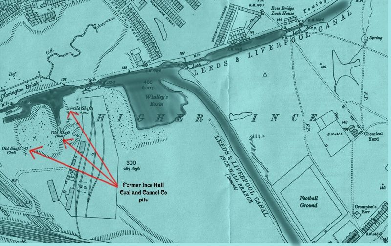
Do you mean these shafts, Flaggy?
The railway lines near the shafts came off the Wigan Central line.
Replied: 14th Feb 2014 at 19:20
Thanks detritus and winder.I think the lines actually come off the L and Y line winder. If you look the Central goes under and the tap off is off the other line.On second thoughts you may be right but the original lines must have been off the L and Y as the Arley pits predated the Great Central.
Replied: 15th Feb 2014 at 08:48
Last edited by flaggy delf: 15th Feb 2014 at 08:51:13
Winder,I'm just glancing through posts at the moment,so without checking in my books and stuff,am I right in saying that these shafts were the ones which the canal broke into and inundated the workings. I think some men were drowned.
Replied: 16th Feb 2014 at 17:30
Hello Chris, hows things?
There was some kind of accident involving water, but I think it might have been the River Douglas somewhere around Scholes area?
The Ince Hall coll near the canal had a couple of serious explosions [gas] around 1850.
I'll see what I can find about the Duggie one.
Replied: 16th Feb 2014 at 18:43
The inquest report on one of the two explosions of the mid 1850s makes interesting reading.
Google Arley Pits Explosion and go to the cmhrc website.
See also The old Mersey Times and go to the mining section for various Wigan pit disasters.
Replied: 17th Feb 2014 at 10:59
Last edited by flaggy delf: 17th Feb 2014 at 11:06:46
Winder makes you realise the awful loss of life in the industry. Have you ever seen the memorial in the graveyard in Silkstone near Barnsley?....it is mentioned in the WC&I big book with the loco on the front. I went to see it and is a long list of little children, brothers and sisters in many instances. Breaks your heart.
Replied: 17th Feb 2014 at 15:26
I am just trying to find my bearings with regard to winder's map:- does it show Clarington Brook passing over what later became the St Pat's rugby ground (also referred to as "The Kimmick")? What is the date of this map?
Replied: 17th Feb 2014 at 19:12
I have read about that disaster, flaggy.
It was at the Huskar Pit at Silkstone, Barnsley.
26 young children drowned in the mine, one was just 7 years old.
John. Your right St Pats ground is the opposite side of canal from the shafts. Britannia Bridge and Shephards Arms is just off the map to the left.
Map dated 1907
Replied: 17th Feb 2014 at 19:40
That's the one I was thinking of,Winder,Lower Patricroft pits,although somehow I'd got in me head that it was the canal which broke into the workings.
Replied: 17th Feb 2014 at 20:42
winder,
thank you for your response. Something that I find odd about the map is its depiction of Manchester Road, which I assume is the dotted track shown to be crossing the canal at "Rose Bridge Lock House". I have always assumed that this is the main route into and out of Wigan in the direction of Manchester but, on the map, it appears to be little more than a track/footpath. Also, it appears to come to an end after a short distance on the Wigan side of "Rose Bridge lock House". It could be simply the way it has been drawn, but I would have expected it to have had greater prominence in 1907. Or perhaps Manchester Road is off the map and isn't actually shown.
Replied: 18th Feb 2014 at 13:01
Last edited by john gormally: 18th Feb 2014 at 13:14:54
John Gormally, Manchester road is not on this map, it is further up the canal, past the Empress mill, which is also out of shot, the little dotted track you are on about is just a footpath leading across the canal to Broomfield Terrace.
Replied: 18th Feb 2014 at 13:36
Thank you, dodger. That explains it.
Replied: 18th Feb 2014 at 13:58

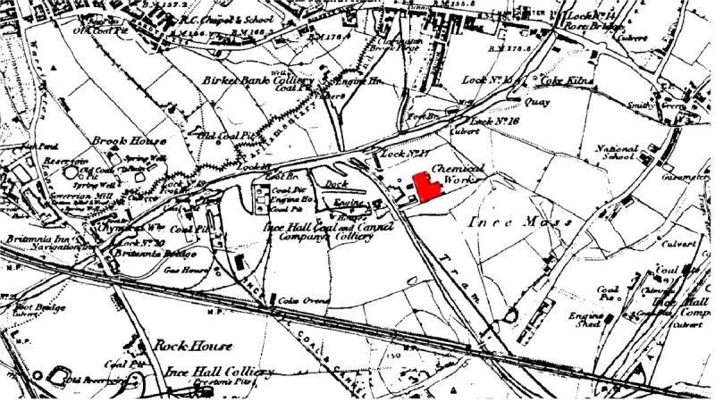
A few years ago the whole of the estate to the right of the picture was excavated and the soil and all growing elements removed and replaced due to the discovery of poisons in most of the gardens, at the time there were various reasons as to why including denials as to how the poisons got in the ground, but clearly marked on the map is a sign saying chemical yard smack bang where the Grove is now, ![]() I also saw a map showing chemical works further down the canal towards Brittania Bridge
I also saw a map showing chemical works further down the canal towards Brittania Bridge ![]()
Replied: 18th Feb 2014 at 14:59
Your right, aitch there was a chemical works on that site. The map is 1849 before Darlington St was built.
Replied: 18th Feb 2014 at 19:07
Thanks winder, thats just behind where I live, they found lead, arsenic and magnesium in mine as well as a small quantity of mercury ![]()
Replied: 18th Feb 2014 at 19:43
Thanks winder, thats just behind where I live, they found lead, arsenic and magnesium in mine as well as a small quantity of mercury ![]()
Replied: 18th Feb 2014 at 19:54
According to old maps, the chemical yard was still there in 1929.
Replied: 18th Feb 2014 at 19:59
The existence of a chemical works in this area is apparently why the St Pat's rugby pitch was referred to as the "Kimmick". I have heard that it was originally a sort of dump for the chemical works. (I don't think there is any accepted spelling of "Kimmick", but that is how it is pronounced.)
Replied: 19th Feb 2014 at 10:11

I was born at 11 harper st 1943 and was allways told kimmick was across canal on William fosters as it was an ammunition dump when I was growing up when they dredged the lake they brought out boxes of bullet shells then they used it as landfill and filled in long arm section on winders picture chemical works is across canal marked in red
Replied: 1st Mar 2014 at 19:29
Last edited by watchalot: 13th Mar 2014 at 18:03:43
bORN IN ASHTON STREET. Scholes.1937.i REMEMBER THE AREA QUITE WELL,I ALSO REMEMBER THE LAKE AND THE HOUSE. jOE n.z
Replied: 2nd Jul 2017 at 05:14
It was the kimmick when i played there as a kid at St Pats in the late 1959s it was on the St pats side of the canal , not a balde of grass in sight in those days
Replied: 5th Jul 2017 at 08:59

 Imbecile !
Replied: 5th Jul 2017 at 14:28
Last edited by tonker: 5th Jul 2017 at 14:29:45