Mine Shaft Puzzle?
Can anyone tell me which Colliery this would have been?
The description relates to the 1950s – Before the M6 was built, and changed the area.
From Soughers Lane (Bryn), along Drummers Lane. Right at the (then),junction, heading away from Downall Green Road. Few hundred yards, on Left, via a Stile, traverse the left margin of field, then turn right, and traverse far margin of same field. Turn Left, and cross the next Field. Emerging from field, turn Right, and follow a long hedgerow on Right-hand side, for about a mile.
Enter Woodland facing you. This was introduced to me as ' Bluebell Wood '. I could never locate it on map. It was profuse with Bluebells, and was Willow, Alder, Birch etc. I think that the trees would be no older than 30-40 years. The A49, to the South, was not visible. Houses on a Road, a little under a mile to the North, were visible.
The Mine Shaft was located in the centre of this wood.. It was poorly protected, having simply been covered by a pair of wooden industrial doors, of the type you would see on a vehicle depot. They were pale grey-blue coloured.
It was a deep shaft, people threw bats down, (I had been bid not to) to hear the 'boing-boing' sound, which lasted for about 4 Sec, before you heard 'Sploosh'. ie the sound of bat bouncing off the shaft walls. The rim of the shaft was quite eroded, so it appeared much had been chucked down, over a period.
Brick-work remains of demolished buildings, not of any great height, were obscured by woodland and Ivy growth.
A vigorous flowing brook, nearby, disappeared underground, through a heap of demolition debris.
Started: 19th Jun 2011 at 14:24
Wots a bat ![]()
Cricket bat ?
Birdy type bat ?
Replied: 19th Jun 2011 at 14:30
Reet then ![]()
Replied: 19th Jun 2011 at 14:42
Ta Dave, over the years, both suggestions from others, and my own pouring over maps, suggest more than half a dozen possibilities, so I am rather hoping that someone will recognise the location, and put me out of my puzzlement.
Replied: 19th Jun 2011 at 15:01
tonker, I bet you never knew there was also a Wood Pit in Wigan.
Replied: 19th Jun 2011 at 15:10
Can you use Google Maps, locate it, then send the image:
Example
A local mine shaft.
Replied: 19th Jun 2011 at 15:11
Taa dave:
I have tried, but the construction of the M6, and the now built-up nature of areas around does not allow me to locate with any precision. And the more than half dozen options are all round, which will only prompt false steers, should my approximate guess be out.
Replied: 19th Jun 2011 at 15:21
ps I cannot even follow my described route on modern maps. the layout of Drummers Lane has changed, at its bridging of the M6, the footpaths gone, and the hedgerows disappeared. I think even the present arable land is in larger parcels than the pasture fields which were crossed by 'my route'.
Replied: 19th Jun 2011 at 16:01
Don't know the name but remember the shaft very well their was no trees near the shaft in the 40s/50s the houses you would see would be Highbrook,we played in that wood as lads
PS- you had to cross the brook over two railway sleepers to get in the wood
Replied: 19th Jun 2011 at 16:15
Last edited by dougie: 19th Jun 2011 at 16:18:08
I have a map of south lancashire coalfields 1907.Your description points to Tan Pit Colliery as a probability.There was a Tan Pit Wood and Tan Pit Slip .Your brook may have joined to Hawkley Brook.Two disused shafts in the vicinity.Meling's farm is not far off ,which I am sure has been mentioned on ww before.
Replied: 19th Jun 2011 at 16:27
Dougie, wasn't there a 'High Brook Colliery' up there somewhere?
Replied: 19th Jun 2011 at 16:35
Winstanley, either no. 3, 4 or 5.
Replied: 19th Jun 2011 at 16:41
Yes their was but that was part of Landgate it was just across from the houses that was a driftmine if its the same one don't know the name
Replied: 19th Jun 2011 at 16:42
I'll go for Tan pit as you could walk through the wood and come out on Tan pit Lane,their was a few cottages there as you came out
Replied: 19th Jun 2011 at 16:47
There is a 'High Brooks' shaft, described in the book 'The Unfortunate Colliery' but whether or not this?????
Replied: 19th Jun 2011 at 16:48
If you click HERE, your computer will explode!
Go on, I dare you! ![]()
Replied: 19th Jun 2011 at 16:51
Last edited by tonker: 19th Jun 2011 at 16:52:19
dougie: Would you not be able to see the A49 from the Tan Pit location?
Replied: 19th Jun 2011 at 16:51
That's a good contender, tonker, there are just so many shafts in the area, I wonder if dougie can confirm it as the one described?
Replied: 19th Jun 2011 at 16:58
ps tonker, loved the spelling of 'Pemberton Roud' ohn map. I Had not seen that one before.
Replied: 19th Jun 2011 at 17:33
Priscus
Thw general area was part of my play area as a young boy.
If you stood at the northern end of Tan Pit wood and looked directly east you would see the railway embankment in front of Glass House farm{Total Fitness}.
At the southern end you would see Derbyshire House farm and the two rows of cottages abutting the Ashton/Wigan boundary.
The orientation of the wood was north easterly from the southern end.
Replied: 19th Jun 2011 at 17:54
Thanks gaffer. Do you recognise my description of the site? Is it consistent with it being Winstanley No. 3?
Replied: 19th Jun 2011 at 18:03
Yes you could see the A49 from the shaft that I am talking about,
Gaffer do you remember the shaft at the end of the Tan pit slip
![]() if you could put the map on again farther to the right down the Tan Pit Slip as the shaft would be down that way, the slip line was about 8 to 10 feet higher than the field and the wood,then Hocky's farm and Highbrook houses was across one small field at the other side of the wood going to the A49
if you could put the map on again farther to the right down the Tan Pit Slip as the shaft would be down that way, the slip line was about 8 to 10 feet higher than the field and the wood,then Hocky's farm and Highbrook houses was across one small field at the other side of the wood going to the A49
Replied: 19th Jun 2011 at 18:05
Priscus
Yes. I guess no 3 pit would be the closest of the three to the line of the M6.
Dougie
As far as i can remember there were shafts along the wood. One at the Ashton, a couple in the middle and a couple at the other end.
Bill Hockey's son, also Bill, went to Park Lane at the same time as myself.
Replied: 19th Jun 2011 at 18:54
His description of it just fits the one I've seen with no fence or trees round it in the 40/50s and it would be in the centre of the wood now after 60 years, see if Tonker put a map on
The Mine Shaft was located in the centre of this wood.. It was poorly protected, having simply been covered by a pair of wooden industrial doors, of the type you would see on a vehicle depot. They were pale grey-blue coloured.
Replied: 19th Jun 2011 at 19:09
Gaffer said, "At the southern end you would see Derbyshire House farm and the two rows of cottages abutting the Ashton/Wigan boundary".
But that's wrong! ![]()
Ashton is not, and never has been, adjacent to Wigan.
It's either 'the Ashton / Winstanley boundary', 'the Ashton / Pemberton boundary' or the 'Ashton in Makerfield Urban District Council / Wigan County Borough boundary'
Take your pick! ![]()
PS: If you wanted to bring it up to date, and continue to classify places by referring to relevant parliamentary / local government areas, you could say the pit was close to the Wigan MBC / St.Helens boundary.
PPS: And that's not forgetting the Greater Manchester / Merseyside boundary for good measure! ![]()
Replied: 19th Jun 2011 at 19:14
Last edited by tonker: 19th Jun 2011 at 19:21:34
I see what you mean now by "computer will explode"
HA
![]()
Replied: 19th Jun 2011 at 19:20
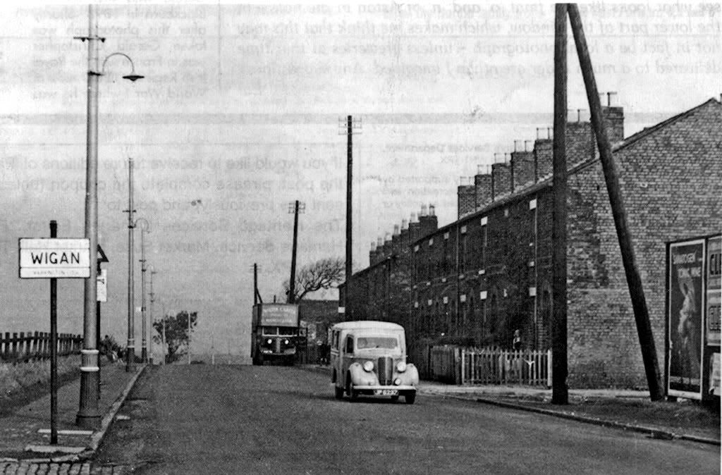
Replied: 19th Jun 2011 at 19:31
Don't believe a sign with half of it out of focus! It's clearly the County Borough of Wigan. Wigan only starts after the River Douglas.
You know that. I know that. So why continue to say otherwise? ![]()
Replied: 19th Jun 2011 at 19:50
It's a simple way of showing Priscus the location and period i referred to.
It doesn't need any unnecessary embellishment and it helps to continue the thread devoid of secondary discussion which is of no interest to the vast majority on here.
Replied: 19th Jun 2011 at 20:07
A little further information. Someone correct me if I have got it wrong.
1 High(er) Brooks 'Drift' is Park Lane 'middle place'
2 High(er) Brooks 'Shaft' is by Coroner's Nook.
3 Map, linked at 16-51 posting, is what you find if you Google 'Winstanley No3'. It is the only image in the Images Portfolio for this colliery. So cannot pan beyond the given view.
Replied: 19th Jun 2011 at 22:37
My hubby thinks it was Qauker House colliery
Replied: 19th Jun 2011 at 23:40
hello mystique how are you hope all is well![]()
Replied: 19th Jun 2011 at 23:50
The only information I have on Quaker House, refers to a 'Drift' mine. No doubt if there was a shaft, someone will come on and tell me.
Replied: 19th Jun 2011 at 23:56
Gaffer, it's always better to be correct. ![]()
Tuddy, sorry I missed you earlier with this post - "tonker, I bet you never knew there was also a Wood Pit in Wigan".
You're right. I do know there was a Wood Pit in Coppull, but I didn't know there was one in Wigan. Where was it?
Replied: 20th Jun 2011 at 00:06
Roobarb ![]()
Replied: 20th Jun 2011 at 06:51
No way could the shaft you have described be the Winstanley number 3, if your in contact with someone that knew the area in the 40/50s, ask them about going through the farmyard to get in the wood the two railway sleepers you crossed to get in the wood over the brook and the pipe we would get water from to drink ![]()
![]() is their a shaft on your map going to the right bottom corner
is their a shaft on your map going to the right bottom corner![]()
Replied: 20th Jun 2011 at 07:26
Priscus
Middle Place drift got it's name by being mid point between Landgate and High Brooks. The 'road' running by the side of the Cranberry development was known locally as Wagon Road. It followed the narrow gauge railway from Landgate to Middle Place and then onwards to Hockey's farm and High Brooks pit.High Brooks consisted of two pits very close together.
Coroner's Nook is close to the site of the pits.
The junior school cross country run followed that route as the easy part of the course.
Replied: 20th Jun 2011 at 09:46
Someone needs to get in touch with these people and try to sweet talk them into giving you the defenative answer for nothing ![]()
Replied: 20th Jun 2011 at 10:06
Last edited by sledge: 20th Jun 2011 at 10:07:06
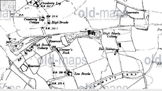
Replied: 20th Jun 2011 at 10:18
Wot's "defenative"?....Would you be meaning "Definitive"?
Or have you invented a new word?...Oh & don't come back with the dyslexic blurb..You normally post 'proper' rubbish (grammatically of course)![]()
![]()
Replied: 20th Jun 2011 at 10:39
Hayi/Hiay/Hiya/Yahi Art ![]()
Bit bored and in need of doing some stirring again? Oh well nothing changes, nowt as queer as folk is there? ![]()
Question???...I have noticed a bit of a Dame Judy around SLG lately, are they putting something on the fields or is it your new aftershave?
BTW....plagiarised any good pics lately??
Replied: 20th Jun 2011 at 10:51
Roobarb ![]()
Replied: 20th Jun 2011 at 12:13
I have only ever entered the location by the route described. It was my favourite walk in 1950s, ceasing abruptly in early 1960s, when M6 construction began.
I am not favouring any answer, but asking the question, and attempting to unravel competing answers. (for more than half a century!)
My route did not cross the 'Wagon Railway' which was still intact at the time. Although no-longer intact, The former route of the Pemberton and Norley Hall Branch of The Lancashire Union Line was discernible over much of its course and this also, as far as I can tell, the route did not cross.
On gaffer's map (posting 10-18) The point at which the route left Drummers Lane, is just off the foot of this map. Crossing two fields, then following hedgerow on right, could arrive at the 'High Brooks' shaft. (two, close to Left hand edge of map) I am not saying it is, but that High Brooks is back in contention.
Could I have reached Tan Pit, without crossing Railway?
The most salient feature of the site was the dangerousness of the shaft. From the direction I have described, you could tell it was a shaft. Someone approaching from the opposite direction, could easily have walked over the doors, without realising there was a mine shaft beneath, and had the wood been rotten; heaven forbid!
Replied: 20th Jun 2011 at 12:19
ps I have a copy of, 'The Unfortunate Colliery' Ian Winstanley's book about High Brooks. Nothing that specifically helps with location of my target shaft though.
Replied: 20th Jun 2011 at 12:37
Last edited by priscus: 20th Jun 2011 at 13:49:26
"nowt as queer as folk is there?"
Seems you're in the know...Naturally in your case..![]()
Let's see, the old cottage spot was not far from the "Cherries" (your haunt)...shame it closed, a convenience lost..![]()
![]()
Replied: 21st Jun 2011 at 00:52
colliery
Dougie, your sister says through the Bluebell wood
was the Tan Pits.
Replied: 21st Jun 2011 at 06:52
Roobarb ![]()
Replied: 21st Jun 2011 at 07:04
Grow up Art.
Replied: 21st Jun 2011 at 07:54
Thanks Frank- Nice to see you both still looking in on WW, see your still having a rough time with the earthquakes it will be in the thousands you by now ![]() ,
,
I think we had some part of the family that lived in the Tan-Pit cottages but I was to young to remember them, don't think she would remember the old shaft that their talking about being a girl ![]() they would take me over to the wood with them in my pram in the 40s
they would take me over to the wood with them in my pram in the 40s ![]()
Replied: 21st Jun 2011 at 08:03
dougie: re your posting (20th, 07-26)
Can you give me any information that excludes Winstanley No3 from contention?
Replied: 21st Jun 2011 at 09:39
Sorry dougie, Apologies for asking a stupid question in post (20th @ 12-19) Looking on 'Godfrey's' 1907 map: of course I would not have had to cross railway.
I had always associated Tan Pit, with the track from (roughly) across from 'Ben Johnson', which I failed to remember crosses to West of railway to arrive at Tan Pit.
Dunce's cap for me there!
Replied: 21st Jun 2011 at 13:13
eeup tonker i worked down Wood Pit in Haydock![]()
![]()
Replied: 21st Jun 2011 at 13:30
I have been able to find out less about 'Tan Pit Colliery' than any other I have researched!
Googling it came up with just 2 finds:
1 Its presence in the list of Local Collieries.
2 This thread.
I'll put a request up as a new topic, and see if anyone local can supply any history of it.
Replied: 21st Jun 2011 at 14:27
Taken from information on Alan Godfrey map of MarusBridge 1907.
The Tanhouse and Tan pits were in production by the mid 19th century and appear to have been transferred to the Winstanley company through an exchange of leases. Served by a railway running westward to the Winstanley railway. The section west of Tanpit abandoned at an early stage probably when LU Pemberton branch was opened and a track from Tanpit ran alongside.Tan pit was basically a pumping shaft,closed in 1897.
Replied: 21st Jun 2011 at 16:43
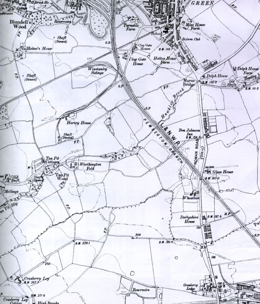
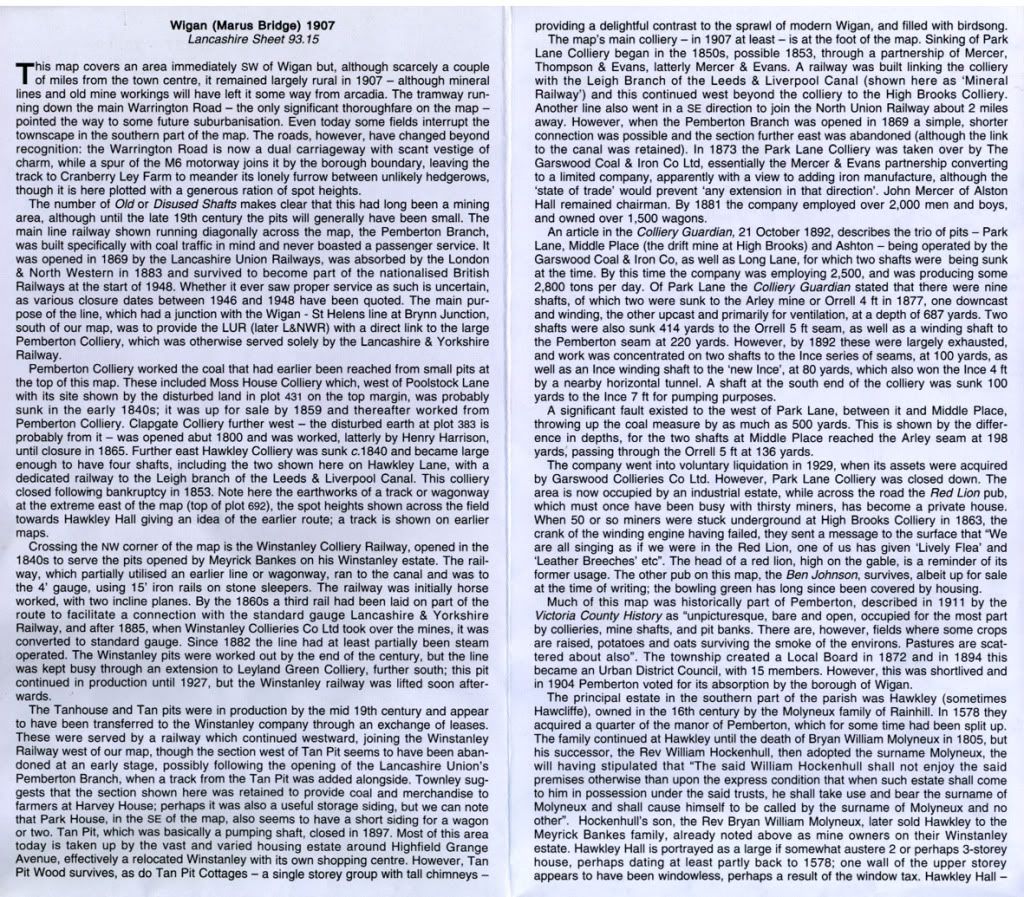
Replied: 21st Jun 2011 at 16:54
Gaffer- looking at this the shaft that I've been on about could have been the pumping shaft, but I can still see it as if it was yesterday
also the thing that looks like a railway line at the bottom right hand corner running to the middle pit, was only a 22" gage line for pit tubs that was lashed to an endless rope, it would take empty tubs to be filled with coal to bring back to Park Lane colliery for sorting
Replied: 21st Jun 2011 at 20:14
dougie: I wonder if you would have known the person who introduced me to the site. He was a Mr Brogan, of Bryn? I do not recall his first name, but he was the dad of the late Steven Brogan, who has been mentioned elsewhere on this site.
Replied: 21st Jun 2011 at 22:16
Hiya tonker, have a look on dave's post near the top of this page, it was Woods pit, apparently in Swinley. I did'nt know about it either.
Replied: 21st Jun 2011 at 22:54
Dougie
It was the railway line i referred to earlier. I used to stop and watch the wagons on my way to school.
Priscus
Was it Herbert Brogan? He died in the late 60's.
Replied: 21st Jun 2011 at 22:57
mygriffiths & gaffer:
Thanks for the info and maps. Odd that the much smaller scale Godfrey (O.S. The South Lancashire Coalfield) Same year ie 1907, actually has 'Tan Pit Colliery' indicated on it.![]()
Concerning Mr Brogan:
Could be gaffer, the name sounds familiar, but I cannot be sure. I left Bryn in the mid 60s, and would not be aware of his passing.
In those days, we were deferential to our elders, so he was usually Mr Brogan to me.
He lived on Wigan Road, close to Rose Hill, and roughly across from Cottams chippy. He had a Golden Retriever. In fact, I was dog-handling for him when he went shooting, which is what we were doing, being in the described location in the first place.
Replied: 21st Jun 2011 at 23:57
Can't bring him to mind but know is son's sad about Steven, David will be in the club on Sunday night,
think this would be the shaft that I was thinking of Art uploaded this map on another thread, I've tried to mark it as the best way to get to it but being as you was shooting you turned left instead of right along the hedgerow and worked your way round

Replied: 22nd Jun 2011 at 09:46
Last edited by dougie: 22nd Jun 2011 at 12:01:40
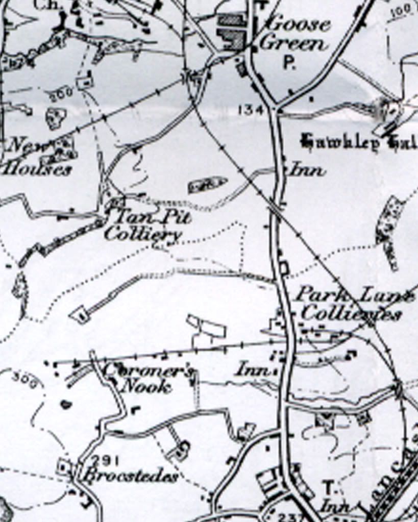
1907 coalfield map.
The narrow gauge railway line running between the Park lane pits is marked on the map.The line running from between the two rectangles to the narrow gauge railway is the path from the explosives store to the drift mine. The rectangles are lodges and the store.
Replied: 22nd Jun 2011 at 09:49
Last edited by gaffer: 22nd Jun 2011 at 09:53:50
Art, Dougie and Gaffer:
Thanks for all the information.
Condolences to David. (I don't think we knew each other,) although I did know Steven, who was in the same primary school class as my sister. Only knew him in childhood however. He would have been about eleven when I left the district.
ps dougie, Should you discover that his Dad was named Herbert, please let me know.
Replied: 22nd Jun 2011 at 19:43
Joe comes to mind as their was a Joe Brogon but will ask David Sunday night,as a matter a fact my auntie was a Brogon before she married and lived at Bryn will ask David about that to on Sunday,
did the map that I marked look anything like your walk
Replied: 22nd Jun 2011 at 21:43
Yeah, that sounds even more familiar, my gran,and my dad where both in business, so lot of local names,(and names I see on this site) are familiar to me, even though I never actually knew the person! so I am easily confused.
Yes, it was very helpful. Tan Pit may well be the shaft. Bluebells seemed to grow profusely in that first-colonisation woodland, which eventually established on despoiled ground. I suspect that many were colloquially named Bluebell Wood.
Glebe Wood, and High Brooks, also fit the walk, but unless someone tells me yeah or nay, I do not know if they fit the appearance.
I had to keep the dog on a very tight lead, in the vicinity of the shaft. The eroded lip, where people chucked stuff down, (under the door-coverings) would have made a tempting and fatal 'scrabble-through' attraction!
Replied: 22nd Jun 2011 at 23:25