Wigan Album
Lymm St./Boundary St. area.
28 Comments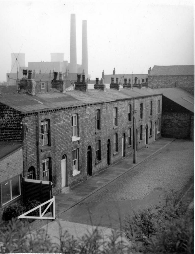
Photo: Allan Greenwood
Item #: 8748
Great photos Allan, what's on the site of the Lymm St./Boundary St area now? so I can try and work our where it was, cheers.
Pretty sure the Bell family lived in the first house?
Lymm St. doesn't exist any more, but traces of Boundary St still do.
Boundary St. is/was the last street on the left hand side of the road (going towards lower Ince) before the canal bridge. Opposite Orrel St.
Lymm St was the street before, that ran parallel to it.
The Bells, unless there was a family living in Boundary street that I didn't know about, lived in Lymm St. The children were named Kenny, Keith and Colin. If this is the family you are talking about I have a photograph of at least Kenny.
Cheers Allan and thanks again for the great photos.
Thanks for correcting me Allan. It is the family you mention, I went to Warrington Lane Junior School with Colin.
Any idea where they are now?
Thanks again
Sorry, I can't help you there. My cousin John Jackson went to the same school but was Keith's age I think. He used to live next door to Bert Hill's shop on Warrington Lane.
What was the name of the street which ran parallel with the railway embankment?. There were only about 4 or5 houses. I used to know a lad called Keith Morgan who I believe got killed in a tragic accident at Irlam Steel Works. I remember he had two sisters one was Angela.
The map and photo show that there was a short row of houses, as you say, runnning parallel with the railway - but the map gives no name for it, so presumably it was counted as Lymm Street.
Looks like the street has been picked out of a Lowry painting, great photo.
And not a piece of litter in sight, no McDonalds then haha
The street that ran parallel to the railway embankment was 'Silverwell Terrace'. They were 'railway' houses. i.e. they were for employees of the railway, and there were four of them.
Re Ron's comments. Keith's other sister was called Shirley she was the youngest.
A picture of Angela, as a child can be seen on the photo 'children of the area' she is on the front row extreme right.
Pictures of Keith, again as a child can be seen in the picture 'more bathers' he is on the extreme right.
'canal buddies' extreme left, and
'Cute aren't they' centre.
Hi Allen, do you know what happened to Angela? When I worked at Plessey Wallgete, on nights. When I was going home at about 8.a.m. I would sometimes see her waiting at the bus stop in Wallgate. She worked at Billinge Hospital, and I would give her a lift to work. I really fancied her, but she was already courting. :0(
Sorry Ron I have no idea. I haven't see or heard about Angela since I left Lymm St. in approx 1954. i don't blame you for fancying her though, she was lovely even then.
Looking at the 1911 census my G Grandparents lived at 18 Boundary St but counting those houses only gets to No 16?...
I think that you numbering the houses the wrong way round. The house furthest away in the picture was No.16. In Circa 1950 Mrs Yates lived in No.18.
Sorry to be numb, would the next to last be 18 then?
It certainly would, occupied from at least 1950 and probably much before that by Mrs Yates.
If you look under 'Stuff' on this site you'll find the Ince Directory for 1925 which lists (almost) all the houses in Ince - and you can see the names mentioned in various Comments related to this series of pics of Boundary Street, including Yates. Lymm Street, being in Wigan, is not mentioned. Incidentally, the illustration accompanying the Index page for the Directory is a section of the aerial pic I've mentioned elsewhere - so perhaps the full shot is elsewhere on the site.
David, the photo you refer to is here (warning, its a biggy):
http://www.wiganworld.co.uk/images3/lowerince.jpg
I can't remember where I got it from... somewhere off the web a long time ago so its not my pic.
Brian. Thank you very much for the reference to that great aerial image of the area, do you know what year it was taken? It shows the coal tippler (Ince Pier) that the rev. David Long referred to concerning an earlier photograph. Things concerning the railway sidings had certainly changed by the time that I lived in the area. My uncles had lived in Boundary St. since approx. 1919 and I never heard them make reference to the coal tippler for instance. I also believe that the goods yard shown off Darlington St. east used to be a station. Did the line terminate there, or has it always terminated in cenral Wigan (in station Rd.) since it was built?
Thanks again for the great photo.
Hi Allan, sorry I'm no expert on the railway line, perhaps someone else can help. I also don't know when the photo was taken as I found it a long time ago and as it was a superb photo I saved a copy - I'm glad I did. Thank you too for uploading some very interesting and unique photos.
Allan, thanks for some great photos. Boundary St is opposite to where Twiss Bakery once stood before it burnt down. When I worked for BT we used to park in Boundary St and go for our breakfast in Jim Twiss's cafe. It was always packed with the all the Utility employees (BT, Gasboard, Electric, the Council yard next door), even Graeam West used to bring the Wigan rugby players for a big fry up.
The pic is taken from the Central line embankment near the goods shed and looking towards Warrington Lane. On the 1907 map Boundary St has 8 houses on one side and four on the other. The street was dog legged and it looks there might be a couple more houses beyond the lean to building on the right of the pic.
Your right, Silverwell Terrace was owned by British Rail and consisted of 4 houses. My grandad, who was a signalman lived at No. 1. It was off Lymm St and behind the goods shed.
Westwood Cars (you can see their name written on two roofs of their premises over the lines from the turntable on the far right, centre) existed from 1919 to, at the latest, 1926, so that gives an idea of the earliest it could be - but the writing may not have been painted out immediately, so it could be later. At any rate, it's about the same time as the Ince Directory of 1925, so the houses of most of the people named in the area of the pic can be pinpointed.
Lovely picture - though think it could be slightly earlier than the 70's due to the number of X 405 lines aerials! I could be wrong though!
It's certainly pre-1974. The pic on Flickr showing this row has more 625 aerials, including on the nearest house, and the roof of the third house along had been covered in felt, similar to the first two here.
Hi Rev. You keep mentioning photos on Flickr. Can you attach the URL of the photo. in the postings?
This is his series of Ince pics: http://www.flickr.com/photos/fray_bentos/tags/inceinmakerfield/