Wigan Album
OLD MAPS
11 Comments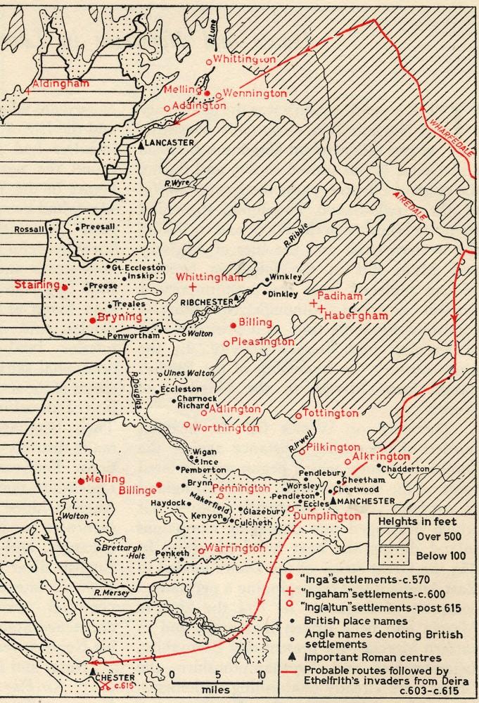
Photo: RON HUNT
Item #: 24476
The theory is that the name "Billinge" is derived from a word meaning "sword" or "edge" hence a prominent hill.
"Bryn" means "hill" in Celtic languages.
So we have two settlements within a couple of miles of each other called "Hill".
But they are MODERN maps, we only know how old these places are, if the person placing them on the map, was correct in doing so. We have no information about how this information has been derived.
AP what a boring git you are... By the way the earth's round and we did land on the moon
AP believe it or not...the information, was no doubt obtained from old maps. Where do you think it came from someones imagination???
Percy
There are NO maps from these periods showing these features.
AP - the legend for the map is pointing to the answer to your question. The places on the map are given their present names - which, the legend explains, can be dated by the form those names take. Different waves of incomers/ invaders used their own language to name their new settlements, and those names have stuck with them up to the present day (though they will have had different written forms, and may have been shortened by those who lived in those places later).
Some places may have had other names previously (e.g. Wigan / Coccium), but it seems that, mostly, incomers used existing place names for what was there when they arrived, and gave new names to any new settlements they formed in other places.
Some places may have been occupied sporadically - that was probably the case with Kirkby, which its name dates it as being settled from about 870AD, but where Bronze Age remains have been found. Kirkby presumably had an earlier name, but if there was no one living there when the Danes came, they would have given it a name in their own language.
Archaeologists uncovering the remains of early settlements in isolated, unnamed places, can only put the place on the map, but they cannot tell you the name it once had, because no maps exist from the time which would give such information.
Hope that helps.
I'd loved to have lived near the River Ribble and given my address as Dinkley Winkley
Gerry, your comment certainly gave me a belly laugh - well spotted.
No Rev. I have not asked any question.
A lot of this material is a matter of dispute and debate among those who study the original source material.
That someone has placed them on a modern map, I merely point out, does not make a case for old maps showing anything.
Sorry, AP, you inferred a question by your statement that we only know how old these places were if the person placing them on the map was correct in doing so.
As I said, the places on the map are where they are now - known by the names we know them as. The date they became known by their present-day names may be divined by the language/ tribe/ invading army which named them.
I don't understand your problem. If Wigan, or Kirkby, or any other place named on these maps was elsewhere than where it is now, you'll have to provide the evidence.
I am sorry Rev,
I have quit using this site, but will make an exception to extend the courtesy of furnishing you a reply.
Take for example, indicating Coccium on the other map.
I am sure you are aware of disputed nature of this. It may be likely, but is an unproven assertion.
How long before someone claims they know its location from seeing it on this old map? We already, on this site, have someone making a similar claim, based upon a well known error in 1st Edition Ordinance Survey Maps.
Similar scholarly debate, though attracting less attention is found concerning the 'provenance' of the name Brynn!
I have a very large collection of Historical Atlases. Very rarely do the maps from one to another completely correspond, because the person producing an illustrative map had to decide what to include or leave out.
Putting what you believe to be historical detail (it is always flawed, by the nature of our understanding)on to a map, does not constitute an old map.
You cannot (logically) create evidence in this way.
The only evidence for historical fact comes from :
1 Primary Source material (incl archaeology)
2 Reliable accounts of these (incl material no longer extant) Though even this is debated.(eg Suetonius)
3 Logic of inference, employing cogent argument based upon valid premises.