Wigan Album
Abram
17 Comments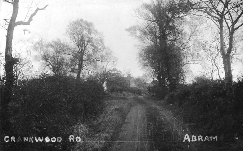
Photo: Mary Sayers
Item #: 8783
Can any body explain why the farm on the photograph is called Lee Lane farm when it is in Crankwood Road
Hello Philip the farm on this picture is not Lee Lane Farm it could be Chadwicks farm before it was rebuilt
It was known as leigh lan e before crankwood was built cos it led to leigh then changed to crankwood road
In Abram there was Lee Lane (near Abram Park, I think this was originally Leechy Lane) and Leigh Lane (now Crankwood Road). if you look on the old census records it seems that the two spellings were often confused, perhaps this is why this was renamed Crankwood Road .... perhaps it was upgraded to a "Road" rather than a "Lane" as it was used more as an access route.
Crankwood Rd was at the bottom of Abram (dover lock end). I used to do a paper round in the 60's from Farrimonds, I think that the first farm along was Hibberts who did milk, I can't remember the name of the next farm but it was later bought by Roberts DIY of Platt Bridge. It was still then an unmade road and I'm not sure if the first part up to Hibberts was privatly owned as there was offset gates at the farm.
Crankwood Road
The following information was provided by a friend from church Mr.Harold Barrow during February 19th 2013. With thanks to Phil Taylor of Abram for proof reading and providing some additional information to the original notes of Harold's.
Originally the road came across from Warrington Road, Abram but only as far as the vicinity of Scotson’s farm where it headed off in a north easterly direction towards New Brick farm. It was then a dirt track and not metalled. The road continued from New Brick farm as a footpath and re-joined Crankwood road as it is now, where the lane to Crankwood farm/bungalow joins it. It thus followed the shape of a dog-leg going first north easterly behind the houses on Crankwood road, before turning in a south easterly direction back towards Crankwood road.
In about 1910 or 1912, the road was straightened out between these two locations so as to give a straight run through as it is today. This was probably done as part of the preparatory works for the houses that were to be built along the “new road” which were built around 1920.
The road was maintained by Abram UDC and a member of their staff, a Mr. Parry, who resided on Crankwood road at the Abram end. Mr. Parry being a general labourer would be released each Friday to fill in the potholes that had formed along its length. By arrangement with the colliery at Plank Lane, spoil was provided by them and brought by lorry as and when required to site and tipped. Mr. Parry had his tools including a wheelbarrow at home and would transport the daily amount required to the section of Crankwood road that required mending. At this time the road was of a width suitable for, and intended to accommodate, the local dust-cart, emergency vehicles and so forth.
The situation seems to have worsened after the nationalisation of the coal industry in 1947. It seems that as well as using flats to transport the coal to Westwood power station, the NBC also utilised a local haulier, Harts of Wigan, to transport a certain amount by road as well to the power station. They considered that Crankwood road provided a suitable short cut and alternative route rather than going either via Golborne or Hindley to Westwood. The dirt road was not intended for HGV’s either in width or surface condition. A local farmer – Mr. Hibbert – who farmed at what is now Lee Lane farm kept his herd of cows in a shippon on the opposite side of the road to his farm. He protested to Abram council about the use by these lorries from the pit, being concerned that the cows he had were being affected by the disturbance and pollution. The herd was “TT tested” meaning that the quality of the milk produced was tested and this quality affected the price that the farmer received. The volume and weight of the lorry traffic was also having a detrimental effect on the road surface.
Farmer Hibbert requested the council to place a formal restriction on the use of the road by placing official notices at either end of the metalled road surface restricting its use to that of normal vehicles, but larger vehicles, ie HGV’s would be prohibited. Apparently, for whatever reason the council did little or nothing to resolve this. cont o/leaf
Therefore, in due course farmer Hibbert frustrated by this protested to Westwood estates who owned both the land on which the farm stood and on which the roadway was laid. The surveyors from Westwood estates came down and restricted the road width back to its “original width” and marked this by installing redundant railway sleepers along both boundary’s and strung old colliery winding rope along between them on each side so as to clearly demark the “official loading gauge”, and prevent any vehicles above a specific width from using it. This restricted width equated to the size of a large saloon car or tractor. Thus the haulier’s lorries were unable to use it any longer.
The remains of this boundary marker may still be seen today in places between Lee Lane farm and Chadwicks farm on the left hand side of the lane as one looks towards the Plank Lane direction. The road was street lit and surviving concrete lamp-standards may still be seen in various places still numbered consecutively from the Plank Lane end.
At some point after this, and towards the time when Abram UDC ceased to exist in 1974, farmer Hibbert frustrated by Abram UDC’s unwillingness to provide the weight restriction notices he wished, decided to take the case to court. Various local opinion was mobilised to object to this and fight it in the courts if necessary. Meanwhile, a barrister advised Abram UDC that they had a good case for keeping the road open with the weight and size restriction on it. A hearing was duly arranged before the court in Liverpool but unfortunately although being advised that they had a good case to retain the road in public ownership, the council declined to fight the case and therefore the farmer was allowed to restrict the road use to its current status, as a footpath only.
Is the building there Crankwood Farm? It used to be owned by my family. Crankwood Farm, Abram was given as the address for William Roberts who died in 1897. I'd love to hear from anyone who might know more.
I have read John Taylor's excellent comment of 23 Mar 13. I well remember Harold Barrow, and the Hibbert family. (Still there?) The sons had a name as first rate ploughmen, if I have it right they won quite a few prizes at County Show level etc. Mary's postcard shows the farm house that in my time in Crankwood was farmed by John and Annie MILLS. The Mills' were very well known for their horse drawn milk round which served Abram, and all the way up to Victoria Street, Platt Bridge. Mrs Mills used to hand carry two churns around her customers in Crankwood for years. That was some effort. John later bought a Ford van which obviously made life a lot easier for them. I believe the farm was called Chadwicks Farm(?) Crankwood Farm I believe was behind the houses in Crankwood Road, adjacent to the actual wood, and was farmed by the Partington family. The lane shown in Mary's picture was the only access the Crankwood houses, and was extensively used by the miners from the Abram area who were employed at Bickershaw Colliery, Plank Lane, and the Plank Lane Brick Works. This is probably the reason why John makes reference to the slag for filling the pot holes that plagued the surface of the lane, and was responsible for ruining many a car spring. The lane was used as a shortcut for hevy lorries going through to Bickershaw Colliery. The Explosives Wagon, and ambulances taking injured miners to RAE Infirmary, Wigan, was a common sight on that lane. If there was ever a problem on the Wigan to Manchester Railway which cancelled train operations, then hoards of miners would walk through Crankwood and down that lane to catch the Wigan Corporation buses which terminated and waited at the junction with Warrington Road. Refering back to Mary's photo - on the right hand side of the lane there are trees immediately on the edge of the road. That is the point at which a rail line from Maypole Colliery ran down to the coal wharf on the Leeds - Liverpool canal. The wagons were then tipped into canal barges for onward movement. There were buildings just below the canal embankment, presumable used by the wharf men. Gates swung across the road at that point when engine and wagons were using the line. The lane was the only way for the kids from Crankwood to get to St John's School. I started at that school before I was five years old. The kids used to meet up and walk that lane in a bunch to the bus terminus. Local car owners then took on the job of ferryng the kids down the lane. I remember that this was taken on by John Mannion, and Henry Williams of Crankwood. The run was later contracted out to a private taxi firm, which from memory was Liptrott of Platt Bridge. When the youngsters reached the age of 10, then they were back on their feet, there was a need to make room for the younger ones coming up behind them. Mr Hibbert allowed bikes to be left at his farm, and that was great. Hope this adds a little for Pam, and again an excellent comment from John.
I have noticed John Taylors very useful and clear observations on the above. I am myself trying to find some information on Abram Park (formally Lee Lane Park). When it was constructed, why it was constructed and whether the paths were laid within the park by the council. If anyone has any knowledge on the construction of the park and dates I would be so pleased.
Does anybody know about the abandoned farm formally owned by the man that killed his wife? I don’t think it had an actual road but it was near Crankwood Road in Abram on the opposite side of the canal
I remember as a kid Hibberts Farm to the Left, Roberts to have a farm further up on the right but somewhere on the right my Uncle Billy had a farm house. After he died it was pulled down, i cant remember fully where it was. Im sure it was between Hibberts and Roberts
Walking along the canal toward plank lane recently i did notice an old abandonded farm house to the right of the canal next to a bridge as someone previously mentioned. I dont know the story behind it.
Sorry All.
I was speaking to my Aunty and my uncle did not live up Crankwood it was up Lee Lane on a farm there. And my Aunty was born in Crab Tree Cottage there they used to be 3 made into 2.
My grandfather farmed Lee Lane Farm until his death in 1943.
we lived at Scotsons Farm from 1982 to 2001
we would be interested to find any history about the farm
I used to live at Scotsons Farm 1960 to 1982 and indeed find this thread interesting. Looking back over my time there I now know what the sleepers with cable on were for which is new to me.
Mr & Mrs Mills did live at Chadwicks Farm until around 1980 ish when after Mrs Mills death Mr Mills moved into a house on Warrington Road Abram.
We moved in 1982 to Widnes and I have been back a few times to see how the place has changed.
Recollections of the place include being able to hear the tannoy at the pit when the wind was in the right direction; watching ghostly figures slowly making progress along the canal behind a big pile of coal, up to 1971. I can also remember going from the station half-way down Crankwood Road to somewhere. Apparently the station was called Bedford Station - can anyone explain that one? The steps and slope up to the station were still there last time I was there.
My relatives, John and Mary Ann Hewitt lived at Crankwood Farm, End of Lee Lane, Road leads off Plank Lane, Abram, Lancashire, England from 1881 with their children. If anyone has any photos or further information I would be really grateful.