Wigan Album
Parish Church, Wigan
4 Comments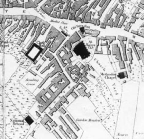
Photo: Rev David Long
Item #: 34236
There was a discussion arising from my P-a-D of Feb 1st about the extent of the churchyard at the Parish Church. In a Comment I made I mentioned this map - and my opinion that King Street West was cut through from Wallgate to the first station (1848) on the Liverpool-Bolton line, which was on the corner of King Street West and Dorning Street. I surmise that it started at the gap to the side of the W, top right, and cut straight through the site of the Methodist Chapel, which closed in 1845 - and then through the bottom end of the churchyard.
David, interesting to think that the burial ground extended so far but understandable when you think of the size of the town. By the way, the first Wallgate station (1848) was to the east of Wallgate itself. The station you are referring to, remnants of which are still visible, was the second station (c 1855), to be superseded by the present station, opened in 1896. Then in 1978 its Victorian station buildings were demolished to be replaced by what we have today (i.e. no licensed buffet, no newspaper stall) but that's another story.
For the Rev David Long...
David I have been emailed some old photos by a relative, some are of soldiers of the 1st WW.
You are an expert on badges etc, is there anyway I could forward the pics to you to see if you can identify the uniform badges, as to what regiment they are?
My email address is here - if you want to send copies to me. But if they're of local interest you could tap a wider range of knowledge by posting them here.
Thanks for clarifying the dates of the stations, John.
On this map you can clearly see that Hallgate travelled all the way up to Market Place before Market Street was built.
I think that little ally way on the left must be Jaxons Court which is still there leading to the bus station.