Wigan Album
Atherton
5 Comments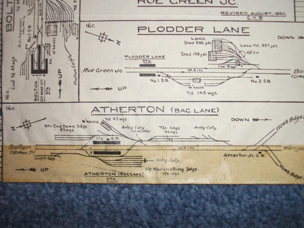
Photo: Chris Heaven
Item #: 31725
My first job on leaving school was at Stotherts in Bag Lane, bus from Norley Hall to Wigan, Wigan to Hindley, Hindley to Atherton and walk up Bag Lane! This was 1964 I can honestly not remember any railway stations, or remains, but after that journey you wouldn't be surprised!
That looks more complicated than a Northern Rail Timetable!
Ed Fort, according to the history books, Atherton Bag Lane closed to passenger trains in 1954, but the line through there lingered on for goods until January 1969 - at the end just between Howe Bridge and Hulton's Steelworks.
I went past the site of Bag Lane station one summer evening as a youngster on one of my first excursions around the local area on my new bike. My parents had specified a certain radius from home where I was allowed to venture - which I promptly disregarded & exceeded by at least 50%.
Anyhow, this particular trip was through Westhoughton, up the hill towards Chequerbent, then down North Road and Bag Lane to Atherton.
I knew from my (out of date) street map there was a railway and a station there, but by this time, 1970 or 1971, British Rail had done a very thorough job of demolition. All that remained at Bag Lane were acres of flattened, derelict wasteland. There were still a few subtle clues of what was one here - the concrete facings to the platforms, brick wall bridge abutments without any bridge over the top, a street named Railway Street and a pub called the Railway Hotel.
I was interested to see this diagram because all those former sidings and marshalling yard explains why there was such a large area of derelict land left behind.
I see from Google Street View that the Railway Hotel has now closed down, but there is still a Railway Street thereabouts.
English Electric,an excellent description of how the land was left after demolition.After this for a few years thousands of lupins used to grow but not any more.The land is still a mess but no doubt some builders will have their eye on it.
The oldest public railway in the Northwest. (There are older colliery railways) it opened before the Liverpool Manchester line. However did not carry passengers on a regular basis until 1831. Was Bolton-Leigh, as they only succeeded in getting the act allowing the development passed through Parliament by inserting a clause assuring that it would not cross the Leigh branch of the Leeds & Liverpool Canal. It fell to the 2.5 mile Kenyon and Leigh Junction Railway, a couple of years on to complete the line through to the L&M.