Wigan Album
Ince
35 Comments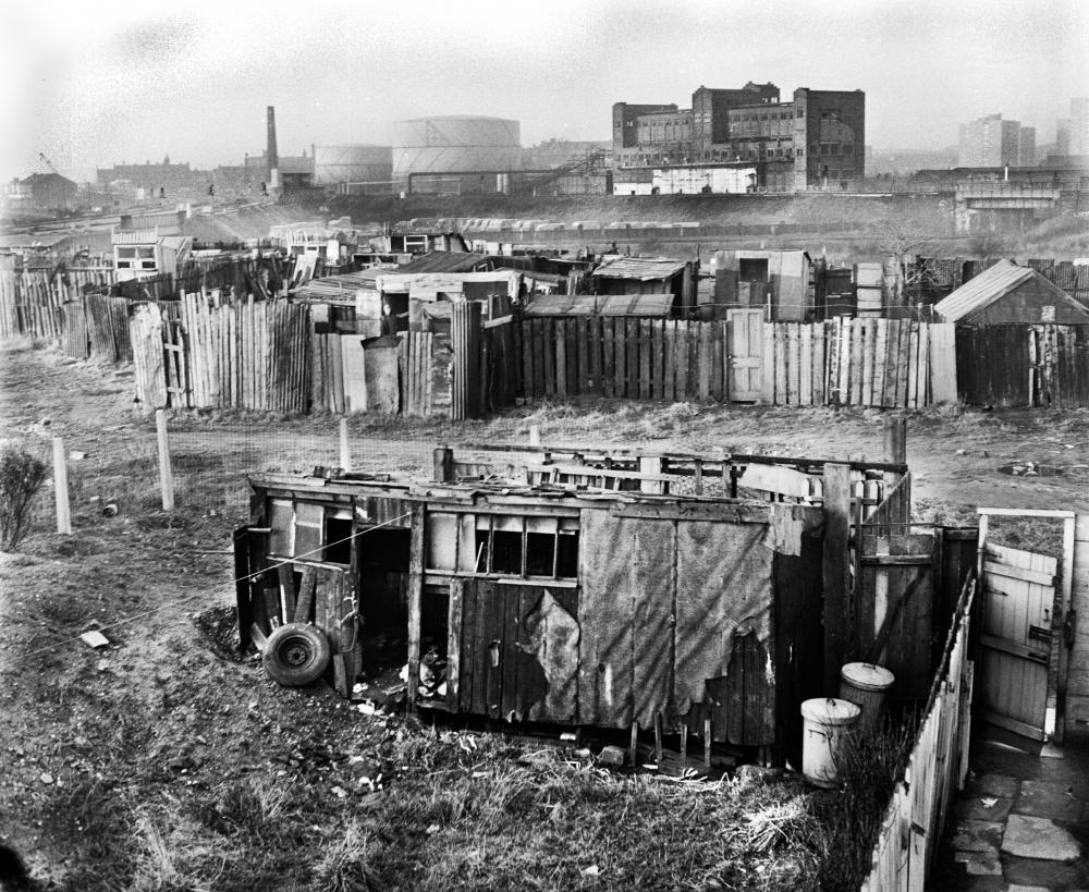
Photo: Frank Orrell
Item #: 29664
Children weren't wrapped in cotton wool as children today are. Me, I used to eat raw sausages, and it never did me any harm. (Cooked ones today though).
Wigan's own ALTON TOWERS.
That site would have been a haven for kids.
When I was a kid, if I'd had the choice of playing on there, or in a playground, the playground wouldn't have got a look in.
What was the large building next to the Gas Holders? I can't remember it?
Ron. Wasn't it the old railway warehouse.
Not sure Ron? i think it was called the retort house.
The thing that strikes me about those day's back then we were happy,also by playing in such surrounding's we never or rarely caught any of the illness's that is associated with today's " Oh keep it clean ,dropped child's dummy oh rinse under tap " back then it was pop into your own mouth and that was that!
I am struggling to locate this building in relation to the Gas Holders??? It must have been a substantial building but I can't remember ever seeing it on any other photos of Wigan?
As someone who has lived in Wigan all my life I can't recall this substantial building at all, yet it must have been there into the sixties since the Scholes multi- storey flats are in shot to the right of it.
Was that building not the old gas works?
Just looked on an old map and it shows the building with railway lines running to it so I suppose it was connected to the Gas Works but I can't remember it! It was at the bottom of Wilton street which was off Sovereign Road
The building is definitely the old gas works. Queued up there a few times for coke when coal was rationed during the war.
The building was part of the gas works . It used to convert coal into coke extracting the gas from the coal
went round it once on aschool trip .it was known locally as the coke works
the big building next to gas holders was the retort house i worked there for a while early sixties
Was it the Coking Plant? i.e. the Retort Plant
The old gas works building has featured in discussions here in the past. It's in the background of a couple of railway pics taken from North Western.
Pens like these used to be all over Wigan - there were still some between Warrington Road and Marlborough Avenue when I came to Ince in 1996, but were finally vacated because kids vandalised them and killed livestock, as I remember. New houses now cover the site. Beyond the pens you can see the line of the L&L Canal - with the bridge under the Wigan-Manchester line to the far right, and the one under the main line on the far left. It's interesting to see a large fleet of vans in the triangle between the two lines. As there are gasometers on both sides of the railways, I suppose there must have been a roadway across that triangle to link them, so a park for vehicles seems a good use for the space - but are they gas board vans, or railway maintenance vans?
Was it the Coking Plant? i.e. the Retort Plant
Does the brook, that was referred to as the Little River, still flow?. It flowed along Donkey Lane, and by the side of the Trenchie pond, and towards Ince Park. Whether it flowed under St Mary's School, I know not.
Albert, the brook runs under Warrington Road at Delph Bridge, between St Mary's Vicarage and the Ince Cemetery Lodge. Immediately below the bridge, in the corner nearest the Vicarage there is a heavy steel grill, through which you can see the water flowing into the brick culvert which takes it under the Cemetery to a siphon which takes it under the WCML, into another culvert under Wigan Cemetery. It eventually flows into Pearsons Flash.
Periodically, a crew come from United Utilities to carry out a survey of the culvert. Wearing breathing apparatus they place a video camera into the culvert and send it through - with images being relayed to a monitor in the van. I once viewed the results - their concern was the presence of tree roots which had grown through the mortar in the brickwork. The offending trees were subsequently uprooted. Presumably they occasionally have to carry out repair work on the culvert, but I was never around if they did so in my time.
Very interesting Reverend. When you are a schoolboy, you are only interested in things that are visible to you. I do not know in what direction the stream flowed in, presumably from east to west, i.e. from Donkey Lane, then under the culvert.
The brook in question according to the Ordnance Survey is, unsurprising, named Ince Brook.
John. D. Ince Brook, as you name it, I remember, about 500 yards passed the Trenchie pond, where wagons were shunted, the brook swung sharply to the left, and flowed along the bottom of the embankment, below the goods railway line, toward Manchester Road. I don't know where its source was.
Ron the large building you refer to is indeed the Retort House, this particular one was built around 1948 according to some rather poor quality copies I managed to find in the History shop a few years ago . It replace d the original Retort that was about 1/3 as high and possible half as long as this particular one. The old being located between the one shown here and the Main running lines.
I have to say that using only a very small amount of modellers licence the area with the ' rat infested sheds.....' is looking rather like it will feature on my layout. Although I am not sure if it would have looked better or worse in 1948 compared to I assume around 1971 when the other photo's of the James Street kids were taken, of course I would be looking at it from the other side as well. But it's crying out to be modelled in all it's glory
Kevan
A place like this today would be raided by the authorities/police or health and safety over the usual excuses like being a death trap, used as a drugs den or used for anti social behaviour.
It's no wonder a lot of kids today have behavioural problems, it's because they are bored as they've no freedom to spend time outdoors unless under supervision.
Alb.
If you look very closely, you will see that the area is fenced of.
This is someone's back garden.
I have that on very good authority.
can anyone please tell me which railway is in the back ground and what bridge is it ? Thanks
Karen,it is Britannia Bridge over the L&L canal ...& carries the L&Y line that runs between Wigan & Ince
Thanks Tom for your reply much appreciated . To the left of the picture there is also another embankment ,could this be the Pemberton Loop Line or a disused colliery line ?.t.i.a Karen
Karen the line on the left is the main Glasgow to London line stopping at Wigan north western
The large building is most likely the retort house which was built around 1880 and lasted till around the 1950s / 1960s.
The big building is indeed the retort house. My father worked on the building of it, inside. He was what was Called a retort setter, I have a photo somewhere. The other side of the building (the front) overlooked part of the gasworks yard, the shops on that side of Darlington street and towered over Darlington street itself.