Wigan Album
Goose Green
14 Comments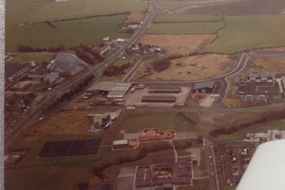
Photo: Eddie.
Item #: 27157
Another reminder. Was the garage at the end of the white cottages on the A49 Unsworths ?? Ted Slevin drove a wagon for them , and a coach of theirs ferried the Wigan R F C team about for years
Is Phythian's farm one of the white buildings further up than Reeds ?
Yes it was AB, I forgot to mention Unsworth's. Cliff Unsworth sold up a few years ago but he's still driving wagons and coaches. I believe his wife also does a bit of coach driving. I've got a few photos of some of his old vehicles which I intend putting on here at some point. I think his former premises is now the site of a car showroom or something of that nature.
annastasia, if you can see the area of cleared land just above Reed's office block, that was the former site of Glass House farm, which belonged to George Phythian. It is now the car park for Total Fitness. Moving further up the picture and past the row of houses we arrive at Unsworth's yard and the Shell garage. Moving up again, the last group of buildings on that side of the road was Derbyshire House farm, owned by the Wadsworth's. Across the road from the Shell garage is Wheatlea farm, the site of H.L.Tractors ,in which business George Halsall was a partner and I believe, owner of the property. Apparently, most of the land in this picture was at one time owned by Squire Bankes. Also, although I don't remember it personally, back in the 40's / 50's, there used to be a bridge across the A49 in this vicinity carrying a mineral line that was used by Squire Bankes to transport coal from his mine at Windy Arbour down to the canal. That could possibly be the site of the bridge, in between Phythian's farm and the row of white houses, where the narrow patch of rough ground can be seen. But that's purely a guess on my part. It would require someone more knowledgeable than me and with a knowledge of mining in this area to put that one to bed.
I'd like to make an amendment to my previous comment regarding the bridge over the A49 at Goose Green. Having studied the 1981 selected revision ordnance survey map of the area. ( Something which I may have been well advised to do earlier ), I have arrived at the following conclusions. Firstly, my guess at the location of the bridge appears to be correct. Secondly, my statement about it being a mineral line from Windy Arbour to the canal would appear to be erroneous, as the line is clearly heading in the wrong direction, towards Pemberton and not Windy Arbour. Also, at it's eastern end, it appears to connect with the Wigan to Liverpool line and not the canal. Now that I think about it, I seem to recall reading about a mineral line that went under the A49 in the vicinity of Moor lane chapel and Landgate colliery. This may have led from Windy Arbour. I'm not stating this as a fact you understand, I'm merely stating that on my map, it certainly seems to be heading in the right direction, and I know for a fact that there is the roadbed of an old tramway that leads directly down to the canal from this area. History is such a tiresome subject. Give me art or woodwork anytime
The photo of the bridge is on this site under Warrington Rd Goose Green Ron Hunt 10175
There is a photo of the railway crossing the A49 on the Ben Jonson bridge. Posted by ayrefield on Wigan world 10th January 2010. I put Marus Bridge into the Google search at the top of the page because I remembered seeing it. It would be roughly near where Taybarns is now.
The bridge was a branch of the Lancashire Union Railway (The Pemberton Branch) There are photographs of it on this site.
The branch joined the line which today runs from Wigan North Western to Liverpool, and ran to make a junction with the Lancashire and Yorkshire Railway, close to Pemberton Station, and it continued on from there to Norley Hall Colliery.
Thanks for the info gents. I've just had a look at Ron's photo. I've never seen that bridge, not that I can remember anyway. I wonder what year it would have been taken down? Anyone know? You can certainly learn a lot of stuff on here and no danger.
Thanks for that, Eddie and for an interesting set of Photos.
Brenda Phythian taught me and my brother at Junior School.
I do not know exact date, but would circa 1950 that bridge was removed. Thereafter, the piers remained in situ for some time: the westernmost remained until the road was made dual carriageway in the 1960's, and the easternmost remained even longer.
The tramway to the canal, to which you refer, is probably that from Park Lane Colliery. The narrow gage mineral line, in the vicinity ran down from High(er) Brooks Colliery to Park Lane.
The famous line from Winstanley/ Billinge Colliery to Wigan Pier crossed the A49 further North, in the Worsley Mesnes area.
I worked on the row of houses between Reeds Unsworths garage had a bit of accident falling from roof to the chamber joust below was only an apprentice lad who was with me told me to get back on the roof he said someone famous would die on that day they did it was Donald Campbell think it was 1967
That seems a bit of an odd comment for your mate to have made Dave. "Bugger gooint casualty, thee get back up yonder, somebody famous is gooin't dee today". Can't get my head round that one.