Wigan Album
Warrington Lane
22 Comments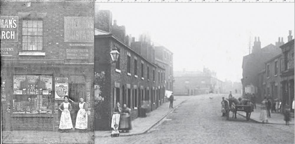
Photo: Ben
Item #: 25111
Its definately warrington lane just before the canal bridge at Brittania bridge, the large building to the left before the bridge is the old Navigation pub.
Its definately warrington lane just before the canal bridge at Brittania bridge, the large building to the left before the bridge is the old Navigation pub.
Warrington Lane (in Wigan Borough) "finished" at Boundary Street (hence the name), and Warrington Road began which was in Ince. The shop, on the left, was the first building in Warrington Lane, as evidenced by the street name and was in Wigan Borough.
does look to me like two pics posted over one and another
are you saying that's the sheppards arms in the distance.
I agree with you baker boy, they are two photos side by side.It's more noticeable at the bottom where you can see the join. However, they are lovely photos Ben. On the right hand side where the building goes in I think is where there used to be a barber's shop with its traditional sign and later, there was a transport café.
Sorry, I should have read the description before I posted my comments, it's meant to be two photos side by side!
Yes thats the Shepherds Arms just over the bridge, I had a tipple or 2 in both but the Navigation is long gone whereas the Shep is still there
Well spotted Margaret, better late than never Bakerboy.
margreti made the same mistake .but cant see the connection between the two pics.
The shop on the left was on this side of Boundary street, the first building in Warrington Lane in Wigan Borough. You can see the continuation of the houses on the other side of Boundary Street as they continue along Warrington Road which was in Ince. Does that help baker?
Whilst it is a fair supposition that Catherine Hilton's shop stood where you've placed it, Ben, there are other possibilities. I think there was a pub on the corner of School Lane/ Warrington Lane at Scholes Crossing, so I think we can rule out that the shop was at that end of Warrington Lane. The street name would also be placed at intermediate main junctions - such as where Darlington Street East and Hardybutts meet Warrington Lane - to enable you to check your bearings. Knowing the street number of the shop would resolve the matter.
With regard to Reverend Long asking about provision shop address.In the 1911 census Catherine Hilton is a shopkeeper aged 49 at 100 Warrington Lane which was on the corner of Boundary Street.
I think that settles the matter then, Terence. Strange to think that this would have been the corner shop for the half-dozen casualties of WW1 who lived around this area and who are commemorated on St Mary's Memorial. These ladies will probably have known them, and shared the grief of their families.
I'm presently trying to complete my effort to put a name and story to all 124 on the Memorial, and have spent a bit of time lately going through the newspaper cuttings files in the Museum, so have been reminded of how many around there felt the tragedy of war directly.
Since I last looked at the subject the 1911 Census has become available - which might make it possible to trace the last few I can't pin down. If anyone with access to the Census is willing to give me some time for this, I'd be grateful. You can see how far I'd got by 2007 here: http://www.wiganworld.co.uk/ww1booklet.pdf
Reverent. There was a pub, on the corner of Darlington Street(west), and Warrington Lane "The Foundry Inn" I suppose it was so named, because the Pepper Mill brass foundry was behind it.
An excellent web site Reverent. You are to be congratulated on your commitment, and dedication. Looking at entry No 316. Eli Edwards. I was wondering if he was related to Eli Edwards,who died, as a prisoner of war, in Japanese captivity. World war 2. His parents' lived in Shed Street, Spring View. His name is on the memorial plaque, on the wall of, Ince Parish Church.
Relative to my last entry. If I put 316,sorry, I should have put 36.
Yes, Albert - WW1 Eli was uncle to WW2 Eli. There were a lot of Edwards' in Spring View (and three still go to St Mary's - nephew and nieces to WW1 Eli, cousins to WW2 Eli) - and they moved about a bit - and seemed to have swapped houses in Ainscow and Margaret Streets, and Warrington Road over the generations. When WW2 Eli was born in 1919, and named after his uncle, his family lived at 28 Ainscow Street.
You could draw up a family chart of WW1 casualties related to the Edwards' one way or another - I found a cousin to Eli I hadn't known about when I was researching the newspaper cuttings last week.
Humph! The WW2 tablet on Christ Church! When it was replaced in 2002 it was supposed to have rectified omissions made post-war. (It was erected too soon, before all qualifying casualties were known.) Eric McPherson's excellent 'Roll of Honour' listed all known Wigan Borough casualties in 2001 - from which they could have drawn up a comprehensive list of Ince casualties, adding about 50 names to the original list. I think the new memorial added about four names. I don't know why that Memorial was put there in the first place (except that it went with the bell-tower which was erected as a War Memorial) - most towns and villages found a way of adding WW2 casualties to their existing WW1 Memorials. As a result, Ince doesn't have a comprehensive War Memorial for both World Wars.
The lady on the left below the FRY'S sign is Esther Armstrong, in 1909 she married Edwin Davies and moved to Hindley. The lady on the right in the doorway is Catherine Hilton, the shop owner. This pic can be dated before 1909. Once again, thanks Ben for bringing things to life !.
My pleasure entirely Walter, I really enjoyed the "detective" work from all the clues you provided.
My uncle, John Jackson, and my aunty Betty lived at 98 Warrington lane. Next to 'Bert Hill's' shop.
this has baffled me, if that warrington rd leading to the canal bridge, the houses on the right are raised up with steps leading up to them.