Wigan Album
Wigan
9 Comments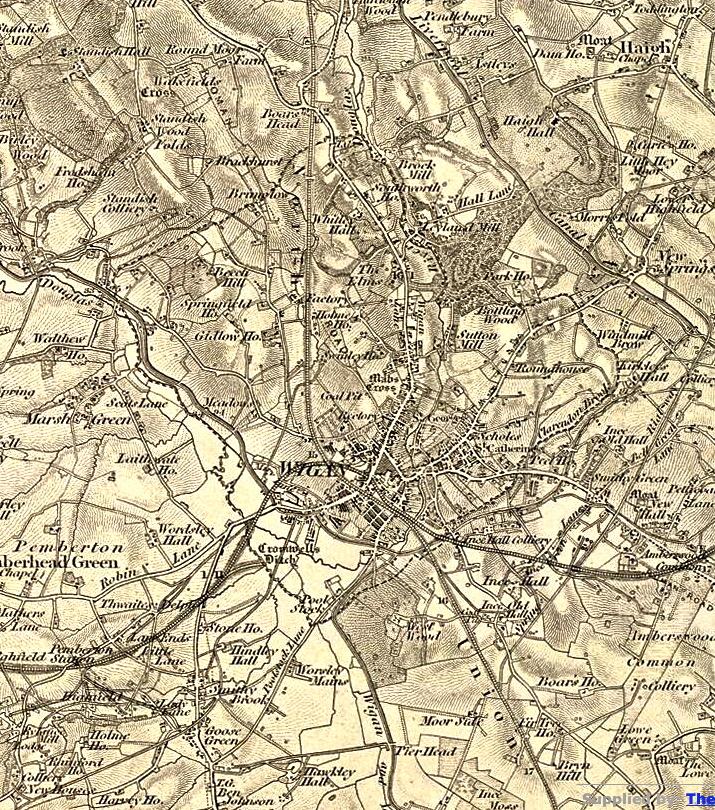
Photo: Keith
Item #: 22489
I notice a couple of things, Clarington Brook looks as if it was Clarendon Brook back then and St Catharines has "lost" the a, i.e. St Catherines, also Cromwell's Ditch is clearly marked.
The population of Wigan, was around 25,000.
Hi Keith. Glad to see Hawkley Hall marked on the map. Also I notice that my area, Worsley Mesnes is marked as Worsley Mains. A bit surprising on an O.S. map. I'm looking for info on Gladstone House which was were Worsley Mesnes Club is now. Anything doing?
Interesting Keith, I note a Robin Lane to Lamberhead Green. This answers an often asked question as to why Newtown is known as " ROBIN".
Hi Jim, can't see what you're after but if you can access the email address I gave you can study the whole of the area. The Ben Johnson is clearly marked and this is where 50 years earlier in 1794 the first miner's trade union in Lancashire was formed. It was called the "Brotherly Union Society", as unions were illegal, it operated in the guise of a friendly society.
Can anyone tell me anything about the track or road that runs across frog lane and across gidlow lane then up to swinley is??
Liam, it's probably a tramway running from a mine to the canal.
Looks like there may have been a Toll Gate (T.G.) next to the Ben Johnson.
Surprised to find a misprint - 'Rail-way' is spelt "Rial-way' along the side of the Springs Branch track, between Ince Old Hall and Kirkless Hall.
I like the idea of there having been a 'Pier Head' on the Leigh Branch of the canal, at the end of the tramway from Goose Green via Hawkley Hall.
where marus ave /cranfield ave is now their was a colliery which looks like the coal was taken out by rail/tramway to moss bridge /pierhead.their is /was a second shaft that backs onto the otherside of poolstock lane at ruskin ave.
Liam think the track running under frog lane gidlow Lane and on to Whitley was actually barley Brook running from Whitley down to the Douglas a lot of it was culverted under barnsley Street and hodges Street