Wigan Album
Wigan Map 1832
4 Comments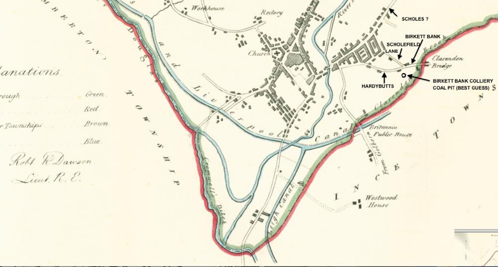
Photo: Keith
Item #: 22080
An interesting old map. Thanks for uploading. What's the key for the different colours? red green etc I think it is to the left of the map and not on the scan? Also what was (or is) Cromwells Ditch that is on the left shown with a thick green line - it sounds interesting.
What a great old map. Strange to think of Wigan being so small. These days its hardly more than a big village really.
Information on Cromwell's Ditch, so called, can be found in issue 48 of 'Past Forward' (Apr-July, 2008) page 9.
It suggests it may be a natural feature which had been wrongly categorised, which has happened frequently on older OS maps.
link:
https://docs.google.com/viewer?a=v&q=cache:y8nuPvm4kVcJ:www.wlct.org/heritage-services/pf48.pdf+&hl=en&gl=uk&pid=bl&srcid=ADGEESg7JT9AIDl5EtrBFMUUYKkbGT3UUIryuKe4xIuRzD8E97mlxHEvNBOd002VTmBNJjajKBRLKNx7JtoeNchlaL-l51-s1m4xRCgxZbV7vae4PPB9HLA87W0GoMuKAZxtTlQT1Q6q&sig=AHIEtbSiZe3mkfwxqmB9k4nXluM2xHupnw
The dip in the bottom of the map underwent some revision in subsequent years, as the Douglas was diverted to follow a line more parallel with the Leeds & Liverpool Canal's route towards Liverpool - and as subsidence put much of the land adjacent to the Leigh Branch under water - and altered the watershed so that water from there flowed south to feed the Glaze / Mersey rather than the Douglas.
This changed the WiganBC/ Ince UDC boundary - which was also the St Mary's / St James' boundary. That has now been changed to follow the line of the canal.
The map makes it easier to understand how Poolstock got its name - as far as I can discover - it looks as if it is so named because there was a bridge, originally comprising a single tree trunk, across the tributary leading into the bottom end of that U-shaped dip in the Douglas, which provided a short cut into Wigan from the west.
Of course, someone may know better....