Wigan Album
Newtown
12 Comments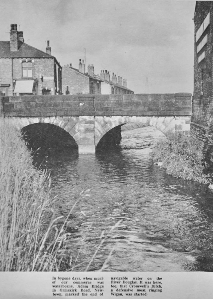
Photo: Rev David Long
Item #: 34178
I hadn't realised that navigation on the Douglas stopped so far short of the centre of the town.
Rev maybe it stopped next to ASDA car park because 200 yards further up is a waterfall.
I am assuming the photographer is standing on the bank at the side of the River Douglas where Screw Fix is in 2023.
The terraced houses with the veranda outside is still there today, although I don't remember the row overlooking the river that are just visible beyond the bridge.
Where these houses demolished to make way for the development of the original Asda store on Soho Street, which would have been built in the late 60s/early 70s?
CJ
When the Wigan Observer changed to web offset printing in late January 1966 and moved to the new works on Woods Street they had all the latest technology in newspaper production at their hands. Once the great Observer team mastered the intricacies of all the equipment they experimented with new ideas. So every week, the Observer printed large crystal clear pictures of places all over Wigan and district and readers loved it. It proved to be a success because it was so different from all other newspapers at the time. Many more new ideas were introduced in the paper and colour pictures were to follow on the front and centre pages. Later that year, the paper won the National Newspaper Design Awards Competition held in London for it's quality and genuine printing excellence.
They were indeed great times.
It looks to me like its looking north towards where Asda is now?
Looking north_west towards Asda, Rich.
I can remember the row of house They always got flooded when the river level rose.
The row of houses were Douglas Terrace, the shop on the end known by local schoolchildren as Dirty Dick's was demolished when the bridge was replaced and widened when the road works began, which, they said at the time would sort out the traffic problems. And as Tonker would say - "well, yer affert laff".
There's a photo on the Album and taken looking the other way: https://www.wiganworld.co.uk/album/photo.php?opt=8&id=7642&gallery=*UNKNOWN*+-+Can+You+Help%253F&offset=40
It's looking north-ish but not towards Newtown.
I went to St Edwards church for a few years. a tiny church up Ormskirk Rd on the left.
Above Douglas Terrace is possibly the chimney of the Jam Works that was located there at one time, also above the bridge wall can be seen an electricity pylon, I do remember these pylons that carried power cables from Westwood power station up towards the Standish area, though I can't remember seeing any pylons along Swan Meadow, the land beyond where the photographer is stood, and looking at this photo by Frank Orrell those cables must have ran underground from the pylon in the distance on this photo or thereabouts and then to Westwood power station, and I'd never realised that before. Does anyone remember the cables running underground in Newtown to Westwood? https://www.wiganworld.co.uk/album/photo.php?opt=5&id=30130&gallery=Newtown&offset=0
I can remember St Edwards church being there Peter, who would have thought at the time when the church moved up to the new one on Scot Lane; that it too would be demolished some 50 or so years later.
This view has changed so much, not being from the Newtown area of Wigan, i was an apprentice plater at Newtown boilers in Gower Street late 1980s and used to cycle around 14 meadows lane and down the back of the bus depot to this bridge, so I've had to look hard at the picture. In fact until i got a start at Newtown boilers from leaving school id never heard of Newtown or visited it!
During lockdown the Wigan Archaeological Society embarked on a project to study the location of Douglas Navigation terminus with reference to the Canal Basin as it is now. Our conclusion was that they are one and the same thing. Our research seems to show that the Navigation stopped well short of Adam Bridge, in fact on the other side of B&Q where the River and Canal come close together. Documents refer to a short section of canal constructed from here to the the Canal Basin (as it is now), with a double lock system connecting it to the River. You can read the full story on our website Newsletter here https://www.wiganarchsoc.co.uk/content/News_Letters/news241.htm