Wigan Album
Gathurst
13 Comments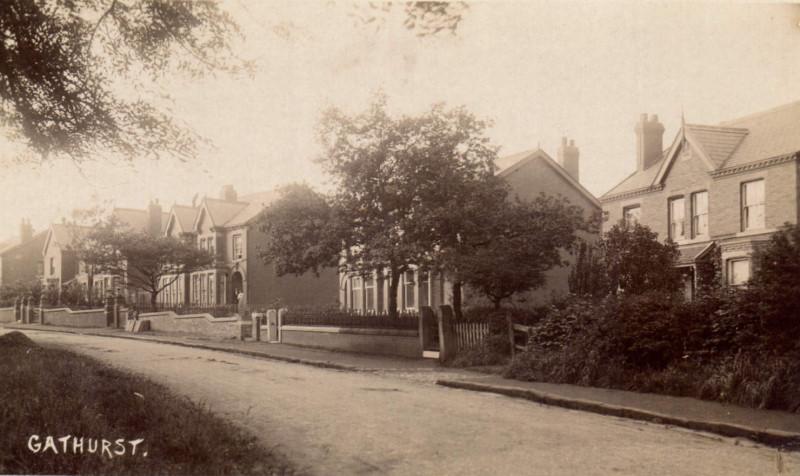
Photo: RON HUNT
Item #: 26467
Mick, is this towards Shevvy?
Yes this is looking up Gathurst lane towards Shevy.
Heinz used the valley in the woods where the cameraman is stood to dump rejected tin of soup and bottles ketchup in the 1960s
These houses are in Shevington!
Ernie NOT Shevington ,never Shevington in the memory of man , Its what it says Gathurst Lane , If you dont know dont guess,
Les Y; It is Gathurst Lane but look how long Gathurst Lane is on a map.
Ernest is correct, it is the lane LEADING to Gathurst, i have a friend living below where the photo was taken and he tells me he lives in Shevington. Gathurst is very small and consists of the canal bridge, what was The Navigation pub, now the Indian restaurant, the river Douglas bridge, the riding school, the railway station, plus the railway bridge and Gathurst brew, which are both on Gathurst Rd.
Jonno; The boundary between Shevington and Gathurst is the River Douglas.
The boundary of Shevington township and parish, is, as Ernest says, the River Douglas. This has always been the case, and various local government boundary commissions over the years have never seen fit to alter it.
Confirmation of this can be found by examination of estate and boundary maps at local record offices and archives.
Although I, like many others, think of the old Navigation pub as being in Gathurst, it is in fact, both geographically and administratively, in Shevington, as is everything else north of the Douglas at that point.
Thanks Mick. Where these the houses on the right hand side after the Navigation Bridge? Gathurst Lane as children we always called Gathurst Brew because of the steep decline . It was our ultimate challenge on bikes how fast our courage would allow us to go. Under the bridge at the bottom a problem as it turned slightly ( there was a sweet shop there)
Yes they are Jude, but quite a way up the lane after the canal, or Navigation bridge as you call it.
The house numbers are in the 120s and 130s even numbers, on the right, as you go up from Gathurst.
Thanks Roy / Mick, Don't know why I called it Navigation Bridge, goes alongside my dreadful grammar that I,ve just noticed . Mick, your detailed knowledge I find amazing. Do you study local history as a hobby or has it just come naturally over the years? Either way you,ve certainly improved my knowledge . And to all on WW
I have a very old map, I hope it helps! At the top of the steep hill is Gathurst fold farm, opposite which is Gathurst wood, at the bottom of the hill is Gathurst station, further along Gathurst Lane is Gathurst bridge over the canal next to the Navigation inn, further north on the left are the Gathurst bridge houses, further still on the left is Gathurst farm and the Gathurst golf club house ( before the m6 when they built Gathurst viaduct) some distance further past Princess road (now princes Park) and at the side of the sharp right hand bend, is Higher Gathurst farm ( later to become Gathurst service station. ) Don’t let the fact that this council has stuck a “welcome to Shevington” sign in the middle of our village fool you, we know where we live!