Wigan Album
Birkett Bank
14 Comments
Photo: Keith
Item #: 22394
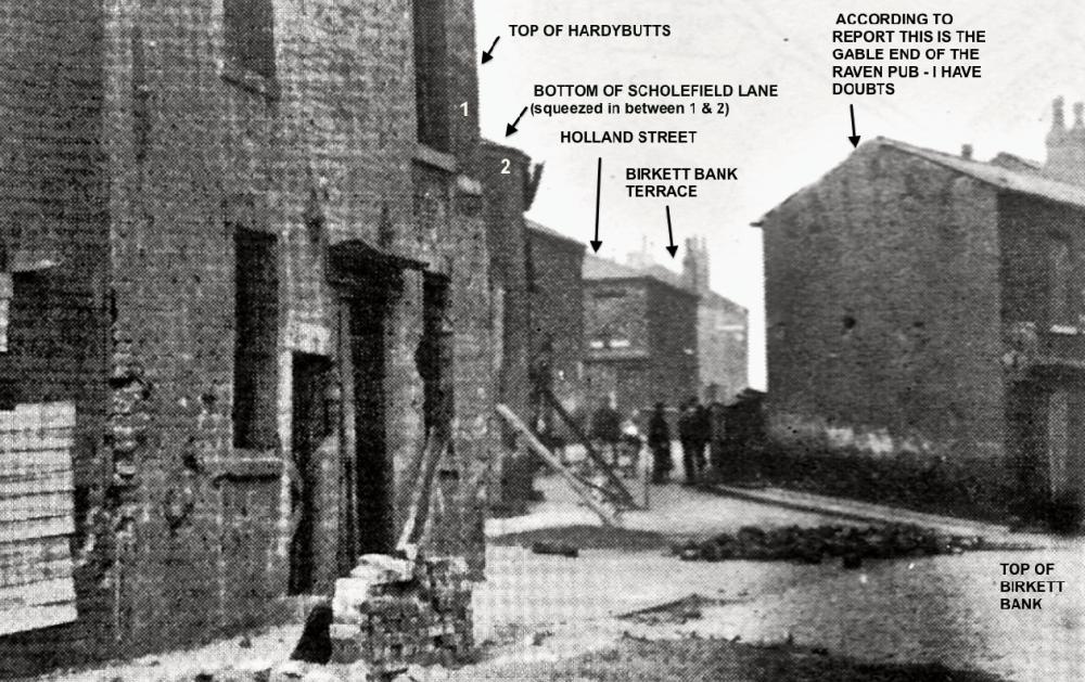
I've tried my best to put in the streets as I think they were but I stand to be corrected by others who may know better. However, although the author says the gable end is the Raven pub I have a 1906 Ordnance map which shows three pubs in Birkett Bank and the one halfway down as far as I know is likely to be the Raven pub, but again I can't be sure. The dark rubble in the street I assume comes from the remains of the large lamp post that was demolished by the German bomb, on April 12th 1918.
My grandmother and grandfather lived in Birkett Bank Terrace thier marriage certificate of 1905 shows No's 9 and 16.
The 1890 census shows her living in Holland St with her widowed mother Catherine Barrow, and 4 brothers and 2 sisters and another family the of 5, named Coupe living there as boarders. As far as I know, most of the houses in Holland St were 2 up and down.
I agree with Keith's identifications, although I can't offer anything on the whereabouts of the Raven. I presume that the large building in the distance and directly under Keith's label "Birkett Bank Terrace" is the old Lodging House. However, I don't understand why the cottages which used to be situated between the Lodging House and Catherine Terrace can't also be seen. Looking at the map which Keith has also uploaded, one would expect them to be visible.
Keith. Although, as you previously stated, the pub had been closed for quite a few years. Did the author of "Zeppelins over Lancashire", make any reference relating to any casualties in that location, as a result of the bomb?
Hi Keith My great grandfather owned the Raven pub James and Elizabeth Barnes i know they were there in 1991 and i do belive it was 29 Birkett bank just after ST Catherines school going towards Ince.They lived there quite a long time.James died there 1909 their son 1920 and his wife 1937,dont know when these propertys were pulled down does anyone know?So you are proberbly right about this NOT being the Raven in the pic but if anyone has a picture with the Raven on it near St Cath school it would be app.
Hi Joy, I know that the Crispin Arms was number 47 Birkett Bank and if you use the map and count down from the "Inn" allowing it to be number 29 it tallies exactly with the Crispin being number 47. Did the author get the name of the pub wrong, maybe it was the Black Bull as mentioned.
That was a shop in later years on the corner , ( 1940's ) we lived in Catherine Terrace.
I recall the gable end shown as being a shop in the 40's and Harry Pemberton living in the house next door as a boy,Ithink there were 2/3 steps to their front door.
I REMEMBER BELLA GREEN'S SHOP ON THE CORNER OF SCHOLEFIELD LANE IN THE 40'S
I was born in Birckett Bank Terrace and we were the last occupants before our house was pulled down in 1958. I also remember the house on the corner being a shop, There was a gap in the houses at the bottom to the steps at the bottom of Holland street leading to Birkett Bank - could this be the raven. The Black Bull was in Hardybutts and there was a pub called the Brown Cow I think after Bella Green's shop on the way up Schoffield Lane towards the school. The Lodging House is not on the photograph, it was after the 'cottages' of Birkett Bank Terrace.
Just looked at the photo again and I think you are right with the arrow pointing to Birkett Bank Terrace, I think it is the house that went round the corner with part in the terrace and part in Catherine Terrace. I also remember (not in 1918) that the men used to congregate where the men are now to pass illegal betting slips to the bookies runner in the late 40s so maybe they were doing it in 1918.
The shop at the gable end showing was Halliwells through the 40,s and 50,s as i recall....opposite was Curless,s papershop top of alleyway to "blind steps" and next to Birkett Bank Pub
Apologies Albert, I inadvertently overlooked your comment re:- author of "Zeppelins over Lancashire" with regard to casualties. Five people in all were killed and nine injured. They were man and wife, Mr and Mrs Tomlinson aged 49 and 58 respectively of Harper Street, 31 year old Walter Harris of Morson's Row, Whelley, and his 5 month old son, Mrs Margaret Ashurst aged 34, a mother of five, of Platt Bridge.
maggie k.i think the brown cow was actually called the spotted cow,wish it was still there.
Would anyone know when the house on Birkett Bank, number 3 to be exact, was demolished, I cant seem to find it on Google Street View. My Grandparents were married in 1919, and my Grandmas address when she married my Granddad was entered as 3 Birkett Bank. Her maiden name was Margaret Alice Delve, and the Wigan Singer Harry Pemberton was related to her, I think her nephew, and someone as stated that he lived in the same area. Thanks for any help.