Wigan Album
PUBS
5 Comments
Photo: Cyril
Item #: 34465
Good information and we'll found!
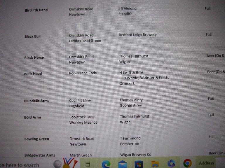
The census records show The Bulls Head was on the site from 1851 onwards. It was listed as being at Robin Lane Ends (Tickle and Swift Houses). Samuel & Ellen Lowe were the occupiers up to 1861. In 1871 and 1881 Richard Leach and his wife Grace had the pub. In 1891 it was Henry Rutter and then William & Catherine Wogan in 1901. By 1911 Richard and Elizabeth Gaskell lived there and the last record I can see was 1939 when John Brown was the licensee. I'm not sure when it was demolished - presumably when the Saddle junction was first redesigned or when Robin Park Road was built. From what others have said it was still there in living memory.
Dave & Paul, in the 1950s when we lived in the prefabs off Buchanan Road and when going with mother when she was shopping at Robin (Newtown) or the shops on Wallgate, I was vaguely aware of buildings around that particular area, though I can't recollect names of shops or the pub or when they were demolished, when coming back from Wallgate we would use a footpath behind those buildings to get up Albert Street to Scot Lane and I can recall seeing a black painted structure somewhere behind there, I've learned from the comments on wiganworld about Robin that it would have been St Edward's club. I can only presume the buildings began to be demolished sometime in the late 1950s, when as you said they began to make the Saddle junction workable without any police on point duty and also when a new Fire Station was being built, though it looks as though a shop and a house was still there in the early 1960s as can be seen on the photo by Frank Orrell and Johnston Press, which had been taken from the then newly built Fire Station, making that having been built during the 1950s. https://www.wiganworld.co.uk/album/photo.php?opt=5&id=30124&gallery=saddle+junction&offset=0
The houses from behind the Queen's Head upwards would have been demolished then too, the pub being left on an island with the bottom ends of Warrington Road and Ormskirk Road made One Way with traffic from Wigan going along Warrington Road then around the back of the island cum roundabout back onto Ormskirk Road, with the traffic from Ashton going around the island cum roundabout too, you can see the Keep Left signs just below the Queen's Head pub on the above photo, and on the photo below, again by Frank Orrell & Johnston Press, you can see the island cum roundabout behind the Queen's Head which had then taken shape, photo taken in the early 1970s.
https://www.wiganworld.co.uk/album/photo.php?opt=5&id=32754&gallery=saddle+junction&page=2
Cyril, what is interesting in the first Frank Orrell photo you referred to is just how narrow the road was in the 1960s. If you look at the present day line of Ormskirk Road from the Tasty House (which was the Black Horse pub until at least 1927) and the old Bird I'th Hand (Interior Warehouse) it seems the sites of both the Bulls Head and the Saddle are now beneath the road.
Also, it is amazing how so many pubs were within walking distance of each other in that part of Newtown. The others that we know about were The Bay Horse (now Aldi car park, which closed before 1911), the recently lost Bowling Green, the Mechanic's Arms which closed in the Seventies, the New Inn (close to the Saddle and which was still open in 1911), the Plough & Harrow (which was demolished in 2009), Prince of Wales, Queens Arms and Queens Head.
i remember the pub building it had been shut down years before ,it was known locally as Jack Browns when open after the wrestler who ran it